A Slight Chance for Showers Monday and Tuesday. Otherwise, Little Change Expected through Next Week
AUG. 8, 2025
The dog days of summer are upon us and no significant changes in the weather are expected over the next several days. However, a few scattered rain showers and thunderstorms will be possible across the entire region Monday and Tuesday.
Friday’s weather maps showed a large ridge of high pressure in the middle and upper atmosphere covering the Central and southwestern U.S. The ridge was causing typical hot, summer-like weather conditions across the majority of Texas. Forecasts call for the ridge to slowly weaken over weekend, then shift off to the west early next week. Meanwhile, a trough of low pressure in the upper atmosphere currently situated between the Yucatan and western Cuba is tracking to the northwest. This trough is forecast to push inland along the Texas coast Sunday, then move northwest west into Central Texas and the Hill Country Monday into Tuesday.
Friday through Sunday
For the Hill Country and Central Texas regions, expect mostly sunny and rain-free weather. High temperatures Friday are forecast to be near 98-100 degrees. Highs Saturday and Sunday are predicted to be in the mid to upper 90s.
For the middle Texas coast, there will be a less than 20 percent chance for spotty rain showers and isolated thunderstorms Friday afternoon. The chance for scattered afternoon showers and thunderstorms will increase to 30 percent Saturday, and 40 percent on Sunday. Daily rain amounts will generally average less than a quarter inch.
Monday and Tuesday
For the Hill Country and Central Texas regions, there will be a 20 percent chance for scattered afternoon rain showers and thunderstorms both days as tropical moisture spreads inland. Spotty totals to near a quarter inch will be possible on both days. High temperatures will be in the mid to upper 90s.
For the middle Texas coast, there will be a 40-50 percent chance for scattered afternoon rain showers and thunderstorms both days. Daily rain amounts will average around a quarter inch, with isolated totals to near 1 inch possible. High temperatures are forecast to be in the mid-90s.
Wednesday through Friday
Mostly sunny and dry weather will resume and remain in place across the region as the trough of low pressure exits to the west, and a new ridge of high pressure begins spreading over Texas from the eastern Gulf. Spotty afternoon sea-breeze-type rain showers are forecast each day across the coastal Plains region.
Daily high temperatures are forecast to be near 98-100 degrees across the Hill Country and Central Texas regions, and in the mid-90s across the coastal plains.
Next Weekend into the Following Week
Forecasts call for little to no change in the weather pattern as our region remains under the influence of a large dome of high pressure in the middle and upper atmosphere. Generally sunny and rain-free weather is forecast. Daily high temperatures are predicted to remain near 98-100 degrees, with middle 90s towards the coast.
Tropical Weather Outlook
Weather conditions are currently quiet across the Gulf and the Caribbean Sea and are expected to remain quiet through the middle of next week.
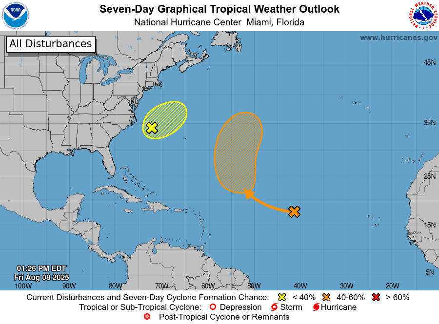
In the central tropical Atlantic, a tropical wave is producing minimal shower activity. According to the National Hurricane Center, development of this system appears unlikely during the next day or two due to surrounding dry air. However, environmental conditions are forecast to become more conducive for development in a few days. A tropical depression could form during the early or middle part of next week, while the system moves northwestward to northward across the central tropical and subtropical Atlantic. The system is not forecast to move west toward the Caribbean Sea. NHC forecasters are giving this system a 50 percent chance for tropic development over the next seven days.
NHC forecasters are also monitoring a weak area of low pressure located a couple of hundred miles off the coast of North Carolina that is producing a few disorganized showers and thunderstorms. Development of this system, if any, is expected to be slow to occur over the next day or two while it moves northeastward at 10 to 15 mph. The low is likely to merge with a front over the weekend, ending its chances for tropical or subtropical development. NHC is giving this system only a 10 percent chance for tropical development over the next couple of day.
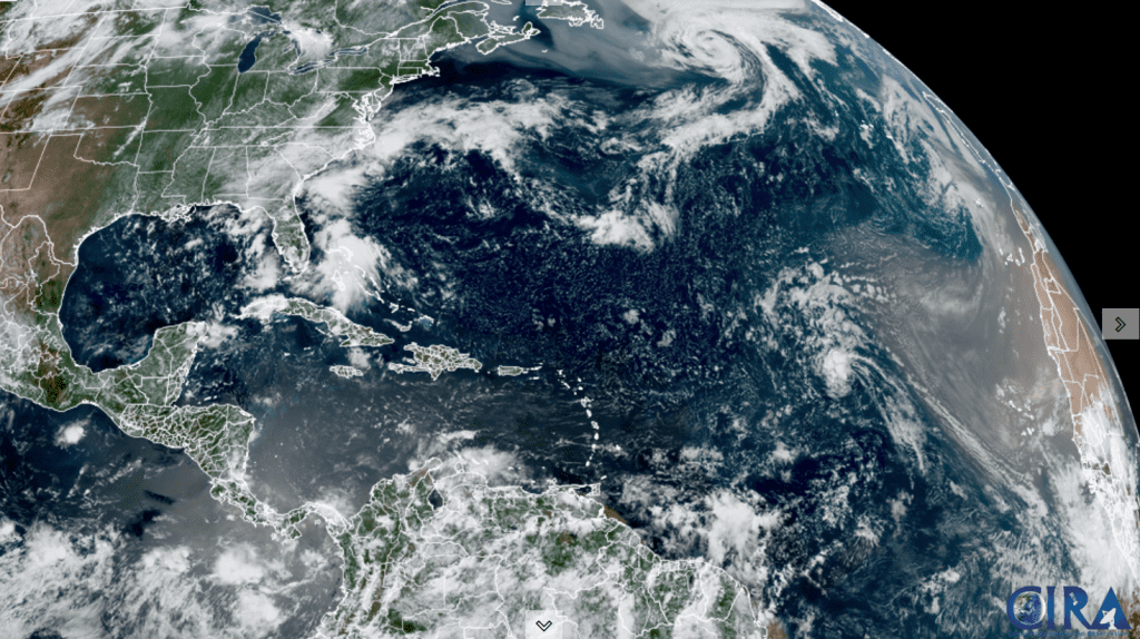
NOAA/Colorado State University/ RAMMB 08/08/2025 1:00 pm CDT
The Sturgeon Full Moon
The August full moon, named the Sturgeon Moon, will reach its peak illumination at 2:55 am CDT Saturday morning. You will be able to see the big full moon rising in the eastern sky on the evening of Friday, August 8, and again on Saturday, August 9.
The Sturgeon Full Moon is the name given to the full moon in August because giant sturgeon, a native freshwater fish of the Great Lakes and Lake Champlain, were abundant and easily caught by Native American tribes and early settlers during this time of year.
Have a great weekend!
Bob
This weather report was prepared Friday 08/08. For the most up to date weather information, visit websites from the National Weather Service.
Social Media