Showers and thunderstorms developed across West Texas Sunday afternoon, with much of the activity tracking to the east-southeast. The most concentrated area of rain and storms spread across the northern Hill Country, in the area between San Angelo, Brady and San Saba. The activity produced spotty totals in the range of a quarter and a half inch. However, some isolated totals of 1-2 inches occurred across parts of McCulloch and San Saba counties. An LCRA Hydromet gauge along the Colorado River near the community of Bend, between San Saba and Lampasas counties, recorded a storm total of 2.29 inches. Spotty rainfall extended south through parts of Llano, Travis and Bastrop counties.
Sunday’s rains took shape as the center of the high pressure ridge shifted from Texas to northwestern Mexico, allowing a small trough of low pressure to push southeast out of the southern Plains. As of Monday morning, this trough was exiting east to Louisiana. However, Monday’s analysis showed a second trough of low pressure was sinking southeast out of western Oklahoma and is forecast to move across North Texas Monday afternoon and evening. Ahead of the trough, atmospheric moisture has increased significantly across Central and Southeast Texas. As the trough moves into North Texas this afternoon and evening, conditions will become somewhat favorable for the development of scattered rain showers and thunderstorms across the Hill Country and Central Texas regions. The probability for rain at any given location will be near 20-30 percent. Rain amounts this afternoon through Tuesday morning are forecast to average between 0.25 and 0.5 inches, with isolated totals of 1-2 inches possible. Across the coastal plains region, this afternoon’s weather is shaping up to be dry. There will be a slight chance for a few scattered rain showers late this evening and after midnight. Monday’s temperature is forecast to generally reach the mid-90s, with low 90s expected towards the coast.
A similar setup is forecast across our region Tuesday into Tuesday night. Forecasts call for another trough of low pressure to push southeast out of Oklahoma, causing a 20-30 percent chance for scattered mainly afternoon and evening showers and thunderstorms across the entire region. Rain amounts are forecast to again average between 0.25 and 0.50 inches, with isolated higher totals. High temperatures will be mostly in the mid-90s.
The unsettled pattern will come to an abrupt end Wednesday as the center of the high pressure ridge begins moving east from northwestern Mexico, shutting off any additional waves of low pressure from the southern Plains. Mostly sunny, dry and hot weather will resume Wednesday and continue through the upcoming weekend.
Wednesday looks to be the start of a heat wave across much of Texas, with several days of triple-digit temperatures expected. Forecasts call for the high pressure ridge to strengthen late week, with the center of the ridge becoming established over eastern New Mexico and the Texas Panhandle. Sinking air around the high pressure ridge is expected to cause a very stable atmosphere and very hot temperatures. But in addition, forecasts call for surface winds to become southwesterly this weekend and early next week. Southwesterly breezes typically cause the development of very hot temperatures across Central Texas. Temperatures are forecast to reach their peak on Sunday.
- Wednesday: High temperatures mostly in the upper 90s, with mid-90s towards the coast.
- Thursday and Friday: High temperatures near 100 -101 degrees across the Hill Country and Central Texas. Mid and upper 90s expected towards the coast.
- Saturday: High temperatures near 101-103 degrees across the Hill Country and Central Texas. Readings reaching near 98-100 degrees towards the coast.
- Sunday: High temperatures near 102-106 degrees across the Hill Country and Central Texas. A high near 100 degrees across the coastal plains.
The outlook for next week calls for little change in the dry and very hot weather through the first half of the week as the high pressure ridge remains quite strong.
- High temperatures Monday through Wednesday are forecast to be near 101-104 degrees across the Hill Country and Central Texas. High temperatures across the coastal plains are forecast to be in the upper 90s.
A slight moderation in the temperature is forecast late next week into next weekend as the center of the high pressure ridge shifts a little further to the west. High temperatures are forecast to lower to the upper 90s by next weekend.
Looking out longer-term, the weather pattern looks to stay generally dry and quite hot through the third week of July.
Tropical Weather Outlook
A weak area of low pressure which took shape northwest of Bermuda over the weekend strengthen into Tropical Storm Edouard late Sunday night. As of late Monday morning, Edouard was located over the north Atlantic, about 435 miles south-southeast of Cape Race Newfoundland. Edouard is moving toward the northeast near 37 mph and this motion is expected to continue for the next couple of days. Maximum sustained winds are near 45 mph with higher gusts. No significant change in strength is forecast before Edouard transitions to a post-tropical cyclone later today.
National Hurricane Center forecasters are monitoring a tropical wave located several hundred miles east of the Windward Islands. This system is producing a large area of disorganized showers and thunderstorms. Some slight development of this system is possible today before environmental conditions become hostile for development on Tuesday. The wave is forecast to move through the Lesser Antilles on Tuesday and could produce locally heavy rainfall and gusty winds on some of those islands. NHC forecasters give this system just a 10 percent chance for development over the next 5 days.
NHC forecasters note a small low pressure system has moved inland over the Florida panhandle. The small low is forecast to evolve into a larger low pressure system and move northeastward, near the coast of the Carolinas. Since the low is currently over land, no development is expected today or tomorrow. However, some development will be possible if the system moves back over water on Wednesday or Thursday. This system could possibly pose a threat to the mid-Atlantic late this week. NHC forecasters give this system a 40 percent chance for development over the next 5 days.
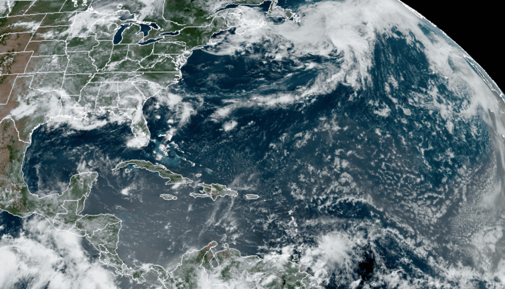
RAMMB-CIRA 07/06/20 12:20 pm CDT
Elsewhere, weather conditions are quiet.
Comet NEOWISE Update:
On July 3rd, Comet NEOWISE flew past the sun near the orbit of Mercury. Some astronomers feared the comet might dissolve. Instead, it held together and became bright enough to see in morning twilight (currently at magnitude +2). As July unfolds, Comet NEOWISE will move into progressively darker skies, further improving its visibility to the naked eye. It will remain a morning comet for the next week, then shift mid-month to the evening sky where casual star gazers can see it without waking at the crack of dawn. When the comet shifts to the evening sky, I will pass along more detailed information on how you can spot it. (Spaceweather.com)
Bob
Social Media