Waves of rain and thunderstorms spread across the region over the holiday weekend, producing significant totals of rain. Numerous locations saw 4-day totals between 3 and 5 inches from some of the heavier downpours. The heaviest and most widespread rain occurred across Matagorda County, where estimates show totals between 4 and 10 inches. For most areas however, the nature of the rain was somewhat spotty, with several locations only picking up a few hundredths of an inch.
Tuesday’s weather maps showed an elongated area of low pressure stretching from northern Mexico, to southern Texas, and east to the lower Mississippi Valley region. The summertime heat ridge we typically see across Texas at this point of summer is located across the western U.S. and also off the coast of the Mid-Atlantic. Forecasts call for the large area of low pressure over South Texas to remain essentially stationary through Wednesday, with the low pulling further west into Mexico Thursday and Friday and this weekend. With the low situated over the region, there will be a good chance for more afternoon and evening rain showers and thunderstorms today and Wednesday, with the chance for rain decreasing some Thursday and Friday.
For this afternoon and Wednesday, the most favorable area for significant rain and thunderstorms is predicted to occur across South Texas, mainly for areas south of U.S. Highway 290. Here, the probability for rain both days will be near 70 percent. Totals on both days are forecast to average between 0.5 and 1 inch, with isolated heavy downpours of totals of 2-3 inches possible. For areas north of Highway 290, the probability for rain both days will be near 40-50 percent, with daily rain totals averaging between 0.25 and 0.5 inches, with isolated totals of 1-2 inches possible. High temperatures will generally be in the mid and upper 80s.
For Thursday and Friday, expect a 40-50 percent chance for scattered rain showers and thunderstorms across the region. Daily rain amounts are predicted to average close to a quarter inch across the Hill Country and Central Texas regions and between a quarter and a half inch across the coastal plains. Isolated downpours of 1-2 inches will be possible. High temperatures both days will generally be near 88-90 degrees.
The outlook for the upcoming weekend calls for little change in the weather as Texas continues to reside between ridges of high pressure over the western and Southeastern U.S. Forecasts call for a trough of low pressure to track east across the southern Plains states, causing the atmosphere to become a bit more unstable across Central and South Texas. With abundant tropical moisture in place, expect 40-50 percent chance for mainly afternoon and evening showers and thunderstorms. Daily rain amounts are forecast to average around a quarter inch, with isolated heavier totals. Expect a mostly cloudy sky both days, with high temperatures near 88-90.
Looking ahead to next week, medium-range forecasts call for more scattered showers and thunderstorms continuing across the region through the first half of the week, followed by a slight chance of rain the second half. High temperatures are forecast to be around 90 degrees Monday through Wednesday, and in the low 90s next Thursday and Friday. No unusually hot temperatures are forecast over the next two week period.
Tropical Weather Outlook
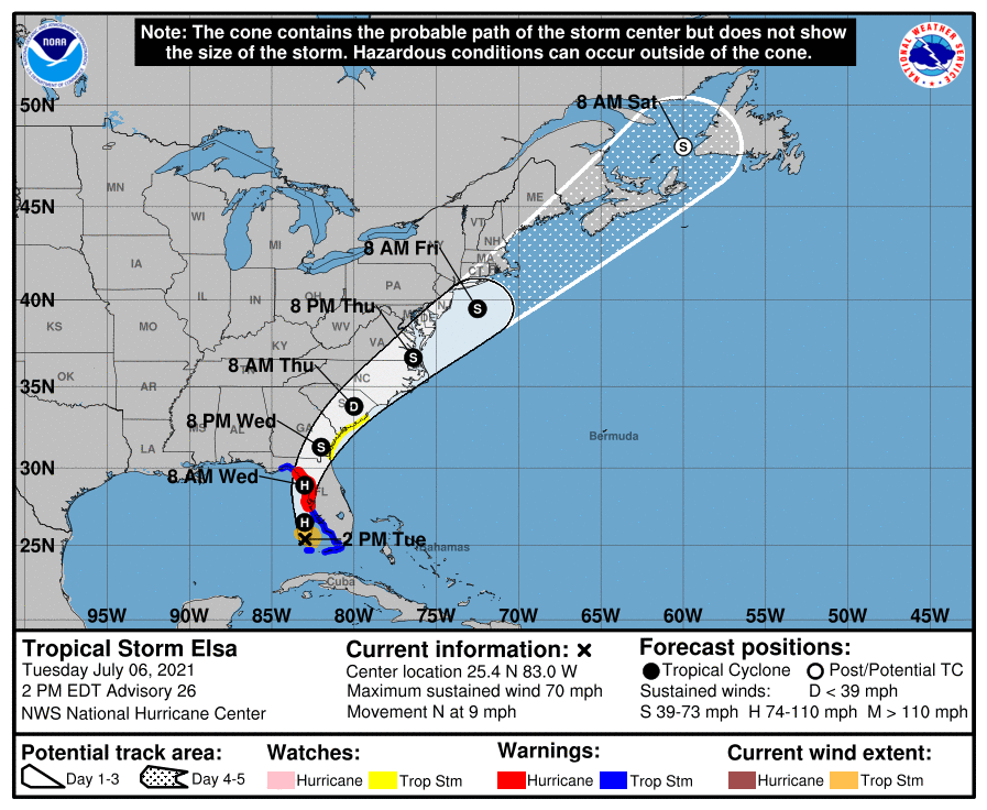
All eyes are currently focused on Tropical Storm Elsa, who is close to regaining hurricane strength as it moves toward the west coast of Florida. Across the rest of the tropical Atlantic, weather conditions are quiet and tropical storm formation is not expected for at least the next 5 days.
As of 1 pm CDT, the center of Tropical Storm Elsa was located about 180 miles south of Tampa, Florida. Elsa is moving toward the north near 9 mph and a generally northward motion is expected today and tonight. A turn toward the north-northeast is expected on Wednesday, followed by a faster northeastward motion by late Thursday. On the forecast track, Elsa will move near or over portions of the west coast of Florida later today through tonight. Elsa is forecast to make landfall along the north Florida Gulf coast on Wednesday and then move across the southeastern United States through Thursday.
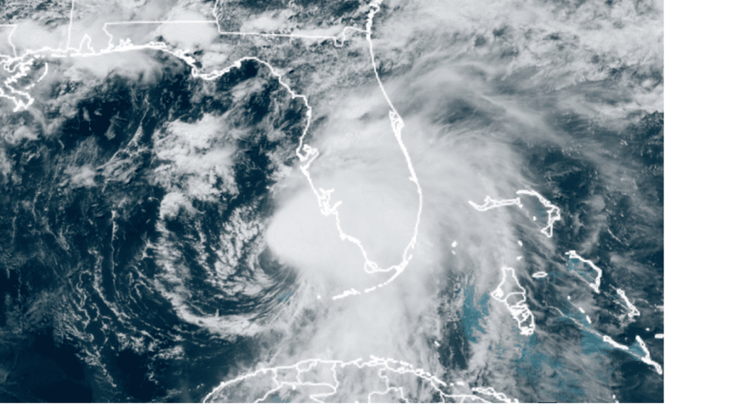
NOAA/Colorado State University/RAMMB 07/06/21 1:20 pm CDT
Maximum sustained winds have increased to near 70 mph with higher gusts, and Elsa is forecast to become a hurricane before making landfall. Weakening is forecast to begin after Elsa moves inland by late Wednesday.
Bob
Social Media