Another Round of Thunderstorms Possible Thursday Night
May 29, 2025
Weather conditions are forecast to remain quiet and dry across the region this afternoon. Expect a partly to mostly cloudy sky, with high temperatures in the upper 80s to low 90s.
Forecasters will be closely monitoring West and Northwest Texas this afternoon as a small trough of low pressure approaches from New Mexico. High resolution forecasts indicate scattered clusters of thunderstorms will develop across this general area along a southward moving cold front. The thunderstorms are forecast to eventually organize into a large complex of thunderstorms that is expected to track to the southeast overnight.
Forecasts call for the complex of storms to reach the area between San Angelo and Brownwood around midnight, spreading southeast across the Hill Country between about midnight and 3 am. The area of storms is predicted to reach the Austin/Interstate 35 corridor between about 3 am and 5 am. The storms are forecast to weaken and fall apart as they push east of I-35 and are not expected to move over the coastal plains.
There is a potential for some of the storms to be strong to severe due to the ongoing moist and unstable atmosphere. The Storm Prediction Center has placed much of West Texas and the northern Hill Country under a Slight Risk for severe thunderstorms through Thursday night. All of Central Texas, including the Austin metro, has been placed under a Marginal Risk for severe storms. Large to isolated very large hail (2-3+ inches in diameter) and severe gusts will likely be the main severe weather threats. There will also be a low potential for a couple of tornadoes.
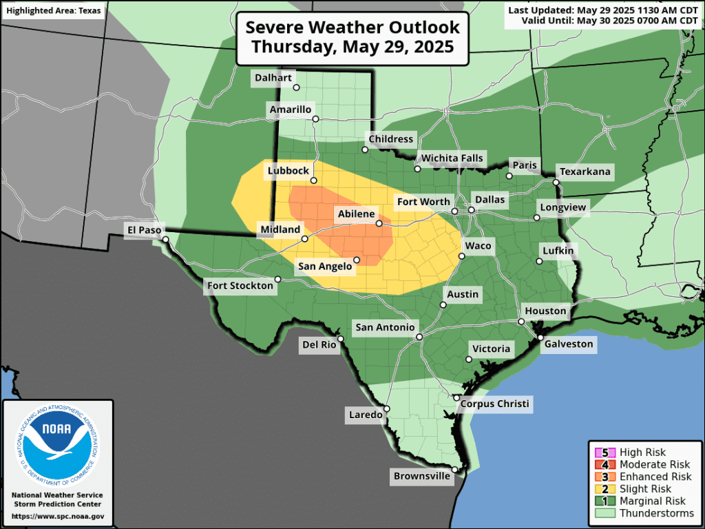
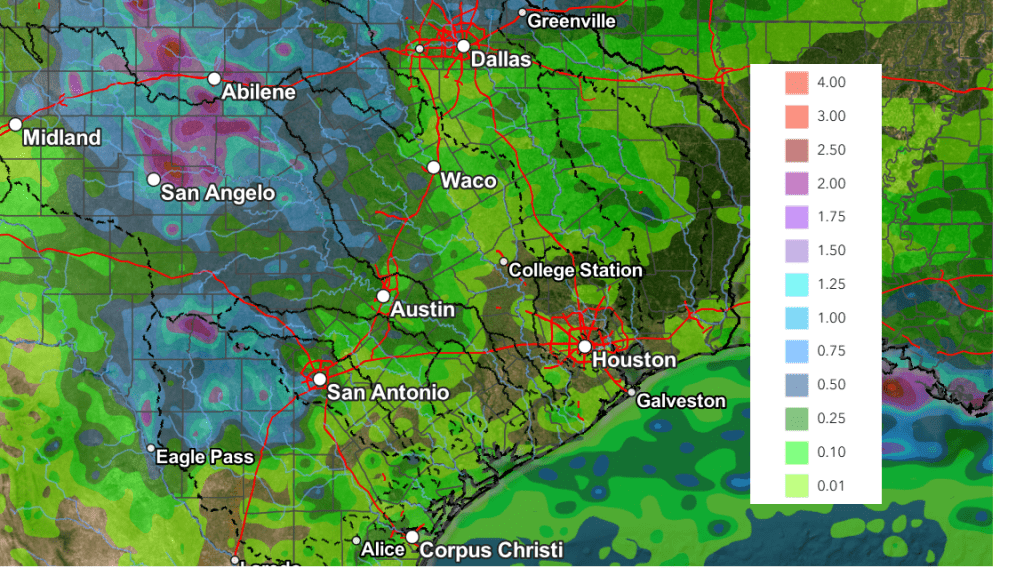
Rainfall from the overnight storms is forecast to generally average between 0.5 and 1 inch, for areas to the west of Interstate 35. However, isolated totals of 2-3 inches will be possible.
NWS Rainfall Forecast Valid through 7 am Friday:
There will be a slight chance for showers and thunderstorms Friday morning as the area of showers diminishes. Generally dry weather is forecast Friday afternoon through Saturday. A slight chance for rain will return to the forecast for Sunday afternoon.
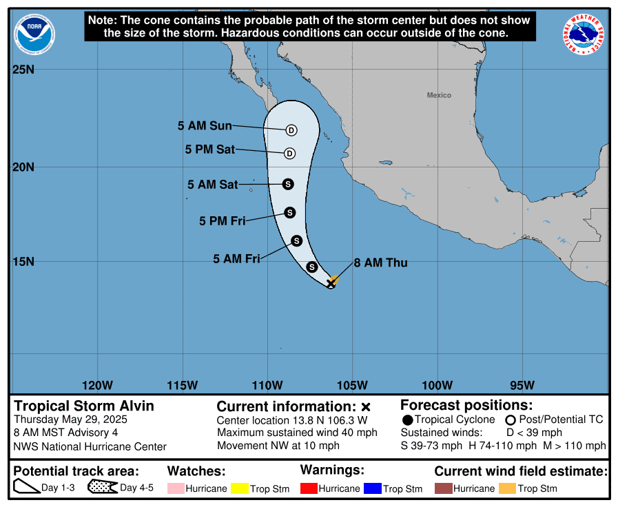
Tropical Storm Develops in the Eastern Tropical Pacific
The first tropical storm in the eastern Pacific of 2025, Tropical Storm Alvin, has developed several hundred miles south of southwestern Mexico. Satellite imagery shows thunderstorm activity has increased and become more organized around the center. Maximum sustained winds have increased to near 40 mph. Alvin should continue to strengthen today, within a favorable environment of warm sea surface temperatures and low wind shear for about the next 24 hours. Weakening is expected to begin tomorrow as the storm moves into progressively higher shear and a drier environment with cooler SSTs. There is high confidence that the system will weaken to a remnant low before it nears the Baja California Peninsula this weekend.
Alvin should have no direct impact on Texas weather.
NWS Survey Team’s Assessment of Wednesday’s Storm in Austin
A National Weather Service survey team concluded a long track microburst, associated with a supercell, occurred from central Austin, near the Hyde Park area, southeast to just east of the Austin Bergstrom International Airport. The length of the damage was approximately 10 miles long, with a path width ranging from one mile to a maximum of around 2.5 miles on the east side of Austin. Numerous trees and powerlines were damaged along the path.
Large tree branches were snapped and a few trees uprooted that had shallow root systems. Minor shingle damage was observed on some homes. Maximum sustained winds were estimated to be between 65 and 85 mph. The Austin Bergstrom International Airport recorded a peak wind gust of 77 mph. In addition, sporadic, non-continuous wind damage was observed into northwest Austin along the supercell’s track. This consisted mainly of small to medium sized tree branches. Part of a gas station canopy collapsed onto two vehicles. Winds through this area were estimated at 55-75 mph. Sporadic wind damage was also observed to the south, associated with the rear flank downdraft. This was mainly damage to small to medium tree branches. In addition, the rear flank downdraft also below out windows on the top of the rotunda at Texas Capitol building.
There was no damage observed that was consistent with a tornado. The survey team also observed damage to tree foliage along the track of the hail core.
NOTE: The information in this statement is preliminary and subject to change pending final review of the event and publication in NWS Storm Data.
Bob
Social Media