Chances for Rain Increase Memorial Day and Continue through Late Next Week
May 23, 2025
Two waves of thunderstorms moved across the Hill Country Thursday night, with each wave producing significant totals of rain across the eastern Hill Country. LCRA’s Hydromet and Doppler radar estimates show a large area of 2-3 inch totals stretching from north of Brownwood, to near San Saba, Llano, and Blanco. Within this area of heavy rain, there were also several pockets of 4-5 inch totals. LCRA’s highest gauged 24-hour total was 6.52 inches, at a gauge located 6 miles south of San Saba. The storms fell apart before moving past Interstate 35. In addition to the heavy rain, some of Thursday night’s storms also produced large hail and damaging winds.
NWS Estimate of rain falling between 7 am Thursday and 7 am Friday:
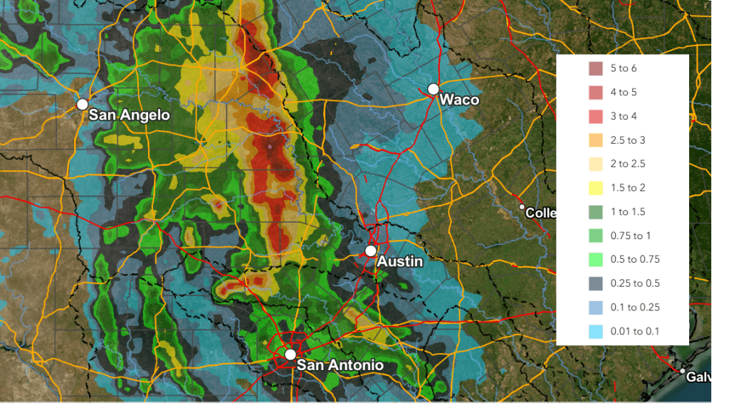
Most of Thursday’s night storms were the result of a complex of rain and storms which had developed earlier across the Texas South Plains and then moved to the southeast. Friday’s analysis shows a more stable atmosphere in now place across the region, and a repeat of Thursday night’s storms is not anticipated.
Sunny and very hot weather is forecast Friday afternoon through Sunday afternoon. No rain is predicted for Friday through Saturday.
- High temperatures through Sunday are forecast to be in the mid and upper 90s across the Hill Country and Central Texas regions, and in the low to mid-90s across the coastal plains
- Low temperatures Saturday and Sunday mornings will include the low and mid-70s across the Hill Country and Central Texas regions, with upper 70s towards the coast
Forecast solutions continue to point to the development of a wet and unsettled weather pattern across the region beginning late Sunday, continuing through most of next week. The ridge of high pressure currently over Texas is forecast to push off to the east this weekend as a trough of low pressure over the southwestern U.S. slowly spreads to the southern Plains. The trough will help draw moisture north from the Gulf, resulting in a moist and unstable atmosphere across much of the state next week. Weak disturbances moving over Texas and boundaries from previous day’s storms will contribute to keeping the chance for rain going through late week. The most favorable period for rain is expected to occur Monday afternoon through Wednesday night.
A slight chance (20%) chance) for scattered rain showers and thunderstorms is forecast across the Hill Country and Central Texas regions Sunday afternoon as the atmosphere begins to grow unstable. The chance for rain and scattered thunderstorms will to increase to 40 percent Sunday evening and Sunday night as a small wave of low pressure approaches from the west.
Memorial Day is shaping up to be partly to mostly cloudy. Attention will be focused on the northern half of the state where a cold front will be slowly sinking to the south. Forecasts call for showers and thunderstorms to develop along the front, with the storms tracking south over parts of the Hill Country and Central Texas Monday afternoon and Monday evening. The front is forecast to reach Central Texas Tuesday morning, then sink south and pull up stationary across the coastal plains Tuesday afternoon through next Thursday. While there is no strong severe weather signal for Memorial Day and next week, given the time of year, I would not be surprised if some isolated strong to severe storms occur next week.
The probability for rain Monday afternoon and Monday night will be near 50-60 percent across the Hill Country and Central Texas regions. Across the costal plains, the probability for rain will be near 30 percent Monday afternoon, then increase to 50 percent Monday night.
For Tuesday through Wednesday night, the probability for rain showers and thunderstorms is predicted to remain near 50 percent across the entire region as passing disturbances bring additional periods of rain showers and thunderstorms.
For Thursday and Friday, the probability for rain showers and thunderstorms is forecast to be near 30-40 percent.
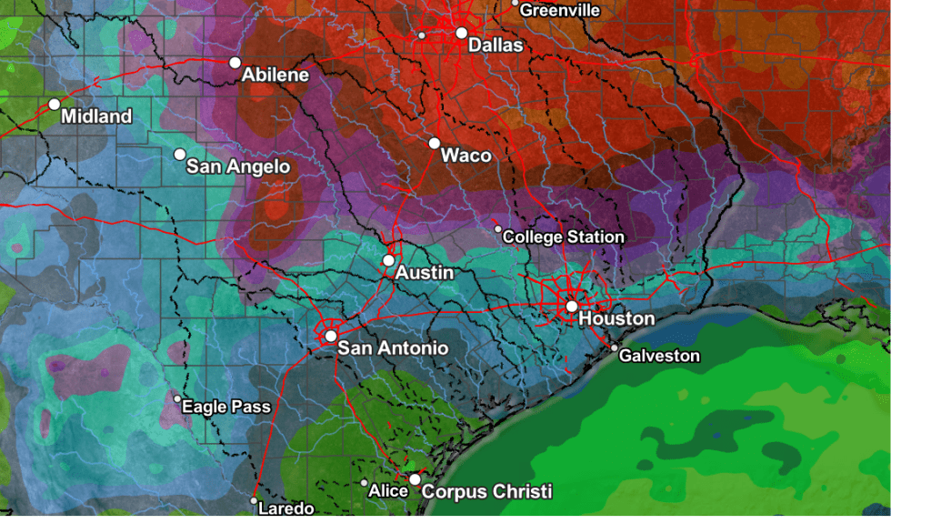
The highest totals of rain over the next week are predicted to occur Monday through Wednesday, with lower amounts expected Thursday and Friday. The National Weather Service’s rainfall forecasts for the next seven days calls for widespread totals of 1-2 inches across the Hill Country and Central Texas regions, with lower totals across the coastal plains. Keep in mind, these are general totals. Some isolated heavy downpours of 3-4 inches will not be out of the question.
NWS Rainfall Forecast Valid through 7 pm next Friday:
Next week’s clouds and rain are expected to keep daytime temperatures less hot. Daily high temperatures are predicted to generally be in the upper 80s. Lows are forecast to be in the 60s to low 70s.
The outlook for next weekend calls for just a slight chance for rain along with warmer temperatures. Highs are forecast to be in the low 90s.
Tropical Weather Outlook
Weather conditions remain quiet across the tropical Atlantic and tropical cyclone development is not forecast over the next seven days.
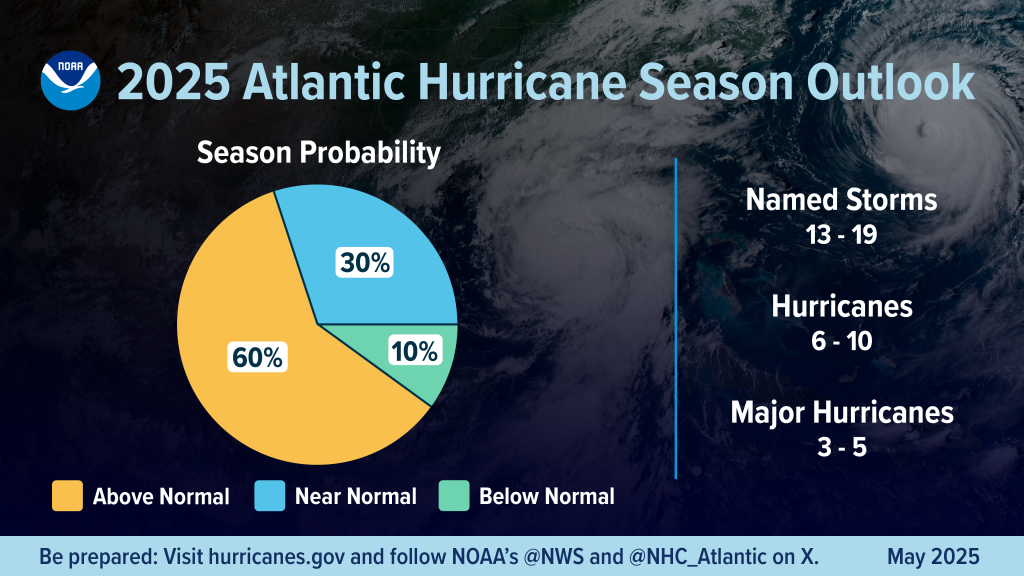
On Thursday, NOAA issued its tropical outlook for the 2025 Atlantic hurricane season. NOAA forecasters are predicting above-normal hurricane activity in the Atlantic this year. The agency is forecasting a range of 13 to 19 total named storms (winds of 39 mph or higher). Of those, 6-10 are forecast to become hurricanes (winds of 74 mph or higher), including 3-5 major hurricanes (category 3, 4 or 5; with winds of 111 mph or higher). NOAA has a 70% confidence in these ranges.
The official start to hurricane season in June 1 and the season runs through November 30.
Wishing everyone a safe and enjoyable Memorial Day weekend!
Bob
Social Media