Forecasters with NOAA’s Climate Prediction Center (CPC) have issued a La Niña Watch, meaning they see increasing evidence La Niña will return (~55% chance) sometime during the September-November period and last through the upcoming winter. A La Niña Watch means conditions are favorable for the development of La Niña within the next six months.
During June, ocean surface temperatures were near the 1991-2020 average across the equatorial Pacific. In particular, the June sea-surface temperature in the Nino3.4 region was 0.25 degrees Celsius below average, well within the ENSO-neutral range. Ocean temperatures in this region have been quickly returning to near-average conditions over the last several months, increasing by nearly half a degree Celsius since April and over a degree Celsius since last winter’s La Niña peak.
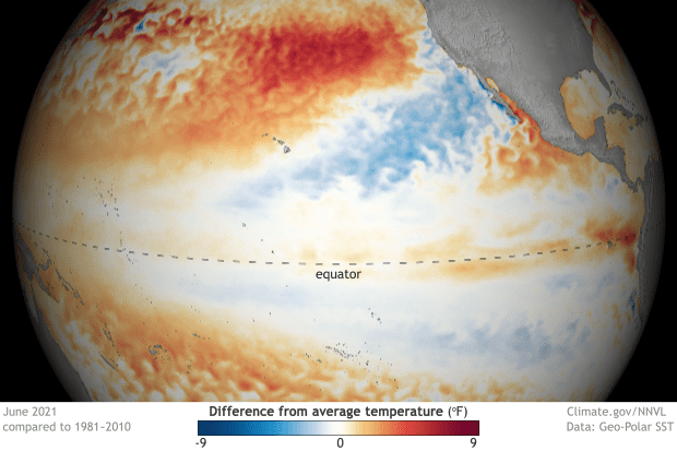
June 2021 sea surface temperature departure from the 1991-2020 average. Image from Data Snapshots on Climate.gov
Subsurface temperature anomalies in June were slightly positive (averaged from 180°W -100°W) and remained steady during the month. However, in parts of the eastern Pacific, below-average subsurface temperature anomalies have developed near the thermocline, the layer of water that marks the transition between the warmer upper ocean and colder deeper ocean. But overall, this cooler water is nothing significant.
For the month, the low-level and upper-level winds were near average across most of the equatorial Pacific Ocean.
Overall, the ocean and atmosphere system in June reflected ENSO-neutral conditions. These neutral conditions are forecast to remain in place through summer and early fall.
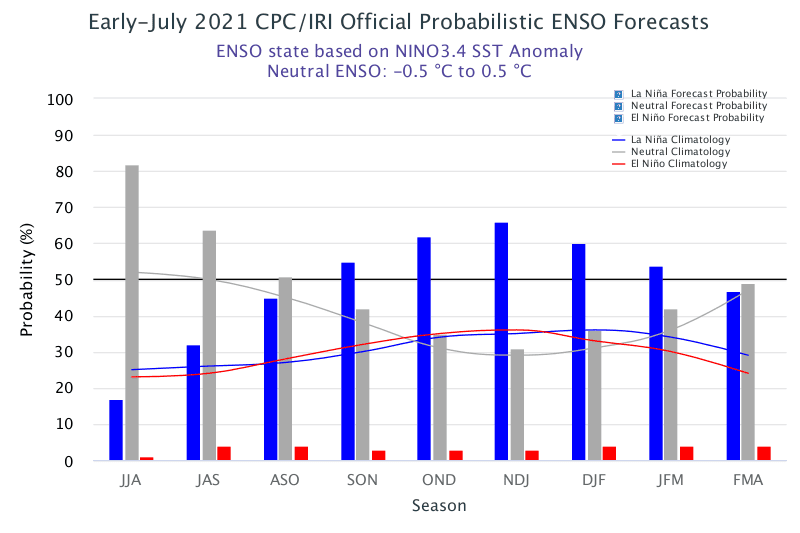
Although a majority of the long-term forecast models predict ENSO-neutral conditions to continue through the upcoming fall and winter, the latest forecast model runs from the National Center for Environmental Prediction’s CFSv2 model and many of the models from the North American Multi-Model Ensemble call for the onset of La Niña during the Northern Hemisphere fall, continuing into winter 2021-22. The CPC forecaster consensus favors these particular model ensembles and therefore is calling for the development of La Niña.
CPC states it’s not unusual to have two La Niña winters back-to-back. In fact, of the twelve first-year La Niña events in the historical record, eight were followed by La Niña the next winter, two by neutral, and two by El Niño.
In summary, according to the Climate Prediction Center, ENSO-neutral conditions are favored through the Northern Hemisphere summer and into the fall (51% chance for the August-October season), with La Niña potentially emerging during the September-November season and lasting through the 2021-22 winter (66% chance during November-January).
Bob
Social Media