Dry this Weekend but Chances for Rain Return for the the Second Half of Next Week
April 25, 2025
This week’s unsettled pattern allowed beneficial rain showers and scattered thunderstorms to develop and spread across the region. Totals since Sunday have generally averaged between 0.5 and 1 inch. However, locations around Lake Brownwood, across northern Fayette County, and the immediate middle Texas coast received substantially higher totals. According to LCRA’s Hydromet, this week’s greatest rainfall accumulation occurred about 5 miles northeast of La Grange, where a training thunderstorm cell produced a total of 5.11 inches!
Friday will offer one more opportunity for scattered rain showers and isolated thunderstorms across the area before a drier and more stable weather pattern takes hold for the weekend. Friday’s weather will be dominated by a very moist and slightly unstable air mass. However, unlike the pattern of the past couple of days, there doesn’t appear to be a strong trigger for rain development. As a result, most areas will see just a 20-30 percent for scattered rain showers and isolated thunderstorms through late afternoon. For areas that do happen to see rain, totals are forecast to average less than a tenth of an inch. Friday’s sky will likely feature plenty of clouds along with some occasional peeks of sunshine. High temperatures are predicted to be in the mid-80s. The sky will be mostly cloudy Friday night. Lows Saturday morning are forecast to be in the mid and upper 60s.
A dry and quiet weather pattern is forecast to develop Saturday and continue through Monday as a stable ridge of high pressure spreads over Texas out of Mexico. This weekend, expect widespread nighttime and morning low clouds, followed by mostly sunny sky conditions in the afternoon. The sky is forecast to stay mostly cloudy on Monday. It will breezy through Monday, with southerly winds in the range of 10-15 mph, with occasional gusts to 20/25 mph.
- High temperatures Saturday are forecast to generally be in the mid-80s
- High temperatures Sunday and Monday are predicted to be near 88-90 degrees
- Lows will range from the mid-60s across the Hill Country, to around 70 degrees across the coastal plains
An unsettled weather pattern looks to return to the region beginning Tuesday. Forecasts call for another Pacific trough of low pressure to settle into the southwestern U.S. early next week, then lift northeast to the southern Plains late in the week. The trough will help push a weak cold front into North Texas around Wednesday, with the front sinking south into Central and South Texas Thursday and Friday.
The combination of small disturbances spreading east around the southwestern trough, an energized West Texas dry line, and the advancing cold front is expected to cause the development of scattered rain showers and thunderstorms starting Tuesday afternoon. Chances for rain and thunderstorms look to continue Wednesday through Friday, and possibly into next weekend as well. As of now, the most favorable period for rain is shaping up to be Wednesday into Wednesday night. Some strong to severe storms may be possible the second half of next week.
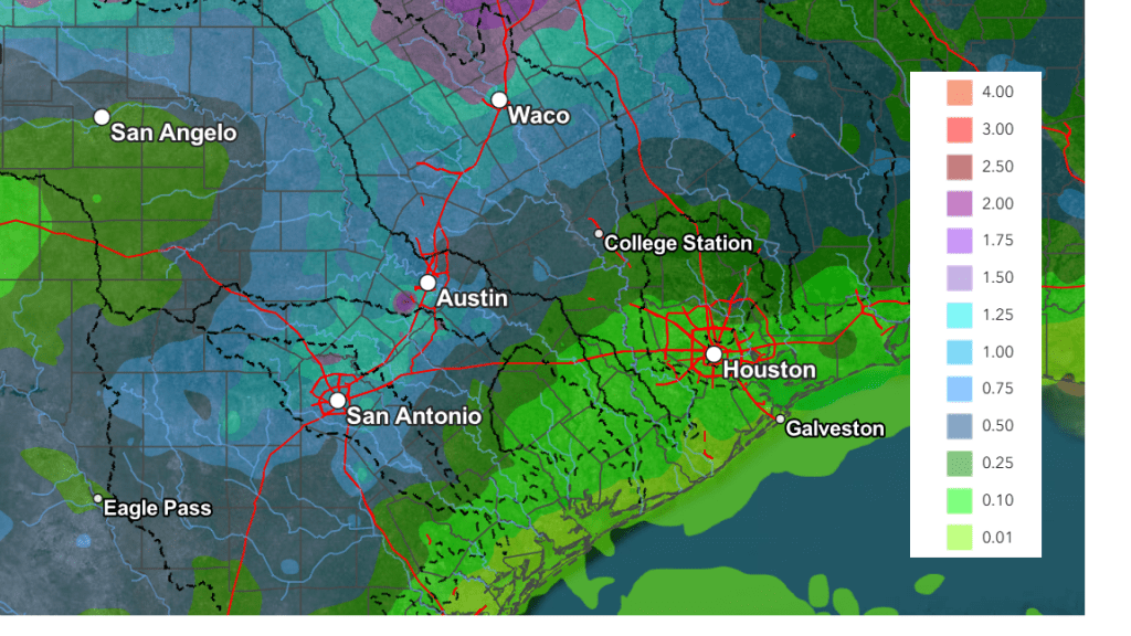
Rain forecasts for next week call for the highest totals of rain to occur across North and Northwest Texas, extending south into the Hill Country and parts of Central Texas. Here, totals of 1-1.5 inches are forecast. Considerably lower totals are forecast for areas south of Interstate 10.
NWS Rainfall Forecast Valid through 7 pm Next Friday, 5/2:
High temperatures next week are forecast to generally be in the mid and upper 80s. Lows are predicted to be in the 60s.
Looking out a little further into the week of May 5th, long-range forecasts call for more wet and unsettled weather across the region.
Have a great weekend!
Bob
Social Media