Dry Weather and Hotter Temperatures Forecast Next Week
June 26, 2025
Another day of scattered rain showers and thunderstorms is forecast for Central Texas and the middle Texas coast Thursday as an enhanced area of tropical moisture continues to spread northwest from the coast. The probability for rain will near 50 percent. Rain amounts will generally average less than a quarter inch, but a couple of isolated totals to near 1 inch will be possible in some of the stronger storms. The chance for rain will extend into Thursday evening, with the activity ending around sunset. Unfortunately, little of the rain and thunderstorm activity is expected to spread west of Interstate 35 and into the Hill Country. High temperatures Thursday are forecast to be in the low and mid-90s.
Friday will likely see a smaller coverage of scattered showers and thunderstorms as some drier air tries to spread in from the east. Forecasts call for a 30 percent chance for mainly afternoon and evening showers and thunderstorms across the coastal plains region, and 20 percent chance for rain across the southern counties of Central Texas. Rain amounts, if any, should average less than a quarter inch. Friday’s high temperature are again predicted to be in the low and mid-90s.
Drier and slightly warmer weather is forecast across the entire region this weekend. The heat dome, which brought a heat wave to much of the eastern U.S. this week, is predicted to weaken in intensity and shift southwest to the Lower Mississippi Valley this weekend. With the center of the heat dome getting closer to Texas, it is forecast to cause a more stable atmosphere, generally dry conditions, and slightly hotter temperatures. Highs both days are forecast to be in the mid to upper 90s across the Hill Country and Central Texas regions, but hold in the low 90s across the coastal plains. Do note some of the forecast solutions call for a small area of enhanced moisture to spread inland along the middle and upper Texas coast on Sunday. This area of increased moisture could cause the development of scattered showers across the coastal plains region Sunday afternoon.
Going into next week, sunny and dry weather and hot temperatures are expected. Forecasts call for the center of the heat dome to slowly spread into eastern Texas out of the Lower Mississippi Valley. While a couple of isolated sea breeze showers will still be possible across the coastal region, no rain is expected elsewhere.
The big news for next week looks to be the trend for hotter temperatures.
- High temperatures Monday through Thursday are forecast to be in the mid and upper 90s across the Hill Country and Central Texas regions, and in the mid-90s across the coastal plains
- High temperatures Friday and next weekend are forecast to be near 98-100 degrees across the Hill Country, near 100-102 degrees across Central Texas, and hold in the mid-90s across the coastal plains
Looking into the week of July 7th, dry weather and very hot temperatures are forecast as the center of the heat some sets up over Central Texas.
- High temperatures are forecast to be near 100 degrees across the Hill Country, near 100-103 degrees across Central Texas, and in the upper 90s across the coastal plains
High temperatures are forecast to lower a couple of degrees late in the week of July 7th as the center of the heat dome shifts west to New Mexico and Arizona.
Tropical Weather Outlook
Weather conditions are very quiet across the tropical Atlantic and tropical cyclone development is not expected for at least the next seven days.
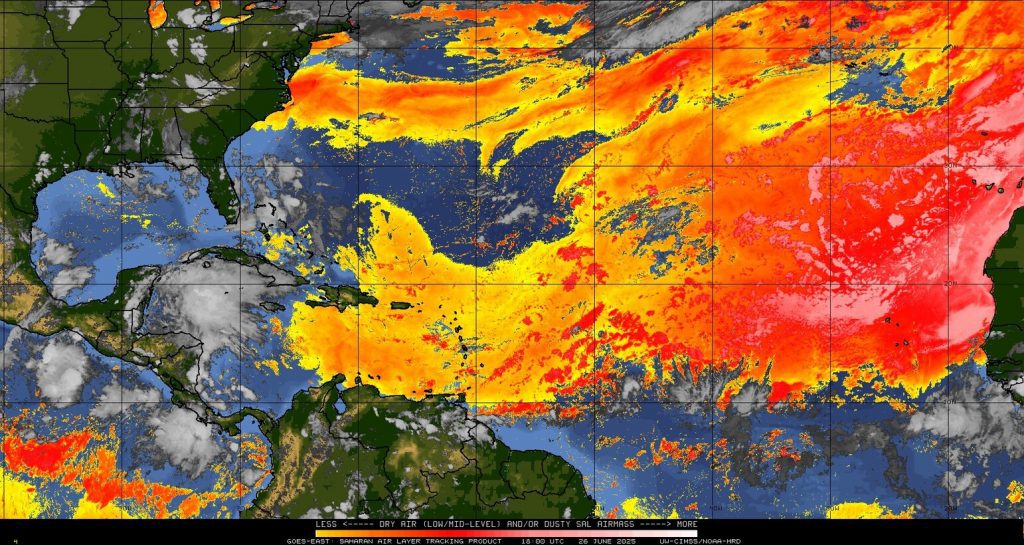
Plume of Sharan Dust Forecast to Spread into Texas
Satellite images show a large plume of Sharan dust located over the Caribbean Sea that is spreading to the west-northwest. Forecasts call for the leading edge of the dust to reach the Texas coast on Saturday, with the area of dust spreading into Central Texas and the Hill Country on Sunday. The area of dust is predicted to hang around across the area into early next week. A hazy sky can be expected while the area of dust holds in place.
Bob
Social Media