Heavy Rain Possible Wednesday Night into Thursday
June 11, 2025
The wet and unsettled weather pattern looks to continue Wednesday night through Thursday afternoon.
The large complex of rain and storms which spread across the Hill Country and Central Texas Tuesday night brought showers and thunderstorms to Southeast Texas and the middle Texas coast Wednesday morning into Wednesday afternoon. As of 4 pm, most of the rain had exited east into Louisiana.
A large trough of low pressure in the middle and upper atmosphere remains in place over Central and North Texas. Although the atmosphere has temporarily stabilized in the wake of the departing complex of storms, additional showers and thunderstorms are forecast to develop and spread across region Wednesday night into Thursday as yet another wave of low pressure circulates southeast into the Hill Country and Central Texas.
High resolution forecasts call for showers and thunderstorms to develop across the Hill Country and the Austin/Interstate 35 corridor this evening ahead of that approaching wave. This will be different from the past couple of nights when the thunderstorms moved into our region from Mexico and Far West Texas. The shower and thunderstorms are forecast to increase in areal coverage throughout the evening hours. Thursday night’s rains are expected to be slow movers, and with the atmosphere still quite moist, locally heavy rain may become a big concern Wednesday evening through Thursday morning.
The National Weather Service predicts the highest totals of rain will occur near and east of the I-35 corridor, for areas generally along and north of a Burnet, to Austin, to La Grange line. Since this area has seen recent rain and soils are wet, the NWS has posted a Flood Watch for Burnet, Williamson, Travis (including the Austin metro area), Lee, Bastrop and Fayette counties. The watch will begin at 7 PM Wednesday evening and will run through 7 pm Thursday. Rain amounts of 2-4 inches will be possible in the watch area, with amounts up to 5-6 inches possible in a few spots.

Forecasts call for the heaviest rains to shift east of the Hill Country and Interstate 35 shortly after daybreak Thursday, spreading southeast to the middle Texas coast Thursday morning. Periods of heavy rain will be possible as the large area of rain slowly moves to the southeast. A slight chance for showers and thunderstorms is forecast Thursday afternoon across the Hill Country and Central Texas following the large area of rain and storms.
Rainfall forecasts through Thursday afternoon call for widespread totals of 1-3 inches across the region, with isolated totals of 5-6 inches possible over the area between Burnet and La Grange.
NWS Rainfall Forecast Valid through 7 pm Thursday:

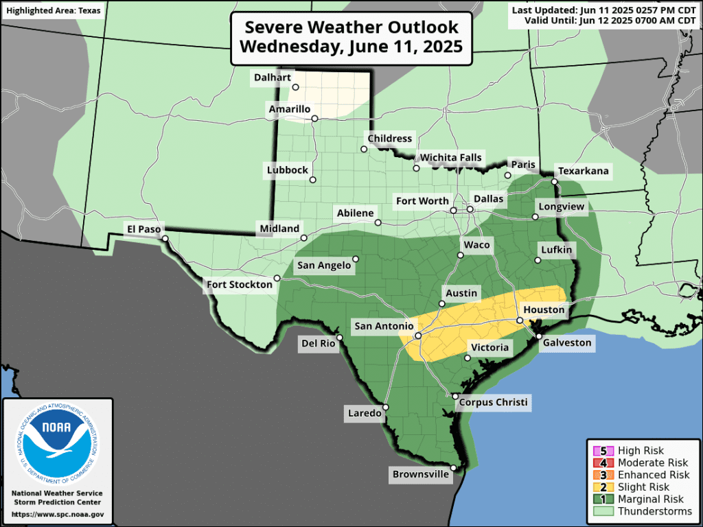
Some of the developing thunderstorms Wednesday night into Thursday morning may be strong to severe. The Storm Prediction Center has place the area roughly between San Antonio and Houston in a 2 out of 5 severe thunderstorm risk. The rest of the area, including Austin and Travis County, is under a 1 out of 5 severe thunderstorm risk. The primary severe weather threats will be large hail and damaging winds.
The threat for heavy rain is predicted to diminish late Thursday as that last wave of low pressure lifts off to the northeast. Forecasts do call for a 20-30 percent chance for scattered showers and thunderstorms across the area Friday through Sunday. However, rain amounts are predicted on only be around a quarter inch.
Bob
Social Media