Confidence is increasing major Hurricane Delta will make landfall somewhere over southwestern Louisiana late Friday afternoon or Friday evening. Delta strengthened Thursday as it moved over the warm, open waters of the southern Gulf of Mexico. The storm has once again attained major hurricane status. In satellite imagery, an eye can now be seen in the cold cloud tops of the central dense overcast. Conditions are nearly ideal for intensification to continue into Thursday night. But as Delta moves northward over the western Gulf of Mexico on Friday, upper level winds look to increase from the southwest due to a trough over Texas. At the same time, Delta will be reaching cooler waters located over the northern Gulf. Both of these factors should lead to some degree of weakening before the hurricane makes landfall Friday evening.
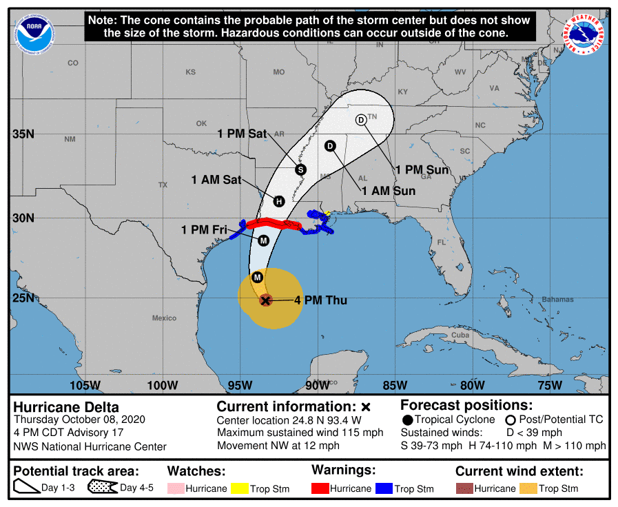
As of 4:00 pm CDT, the center of Hurricane Delta was located about 345 miles south of Cameron, Louisiana. Delta was moving toward the northwest near 12 mph and this motion, with a reduction in forward speed is expected Thursday evening. A turn toward the north is forecast to occur late Thursday night, followed by a north-northeastward motion Friday and Friday night. Reports from an Air Force Reserve Hurricane Hunter aircraft indicate that maximum sustained winds have increased to near 115 mph. Delta is now a category 3 hurricane on the Saffir-Simpson Hurricane Wind Scale. Additional strengthening is possible Thursday night followed by some slight weakening when Delta approaches the northern Gulf coast on Friday. Rapid weakening expected after the center moves inland Friday night through Saturday.
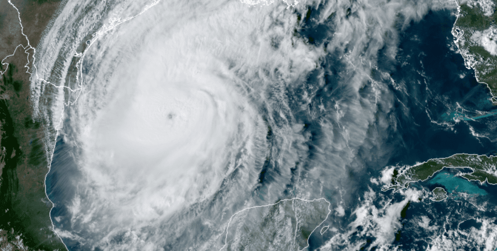
RAMMB-CIRA-Colorado State University 10/08/2020 3:50 pm CDT
Thursday afternoon’s National Hurricane Center track forecast has not changed appreciably since Wednesday. Based on the current forecast track, the center of Delta will move over the western Gulf of Mexico Thursday evening, the northwestern Gulf of Mexico on Friday and move inland somewhere over southwestern Louisiana Friday afternoon or Friday night. The cone of uncertainty at landfall has narrowed and now stretches from the Texas/Louisiana border to near Lafayette, Louisiana.
Clouds on the northwestern periphery of Delta spread inland across the coastal plains region on Thursday. By late afternoon, the clouds had reached as far west as the Interstate 35 corridor. Weather radar also showed a few spotty light rain showers were beginning to spread inland over South and Southeast Texas Thursday afternoon. However, surface reports indicated very little of this rain was reaching the ground.
Light shower activity is predicted to increase in areal coverage across the coastal plains region Thursday night and continue Friday morning and Friday afternoon. Storm totals should average less than a quarter inch. Spotty light rain showers are forecast across parts of Central Texas Friday morning into Friday afternoon, but totals should average less than a tenth of an inch. All of the rain should diminish Friday evening. Dry weather is forecast Friday night through the weekend.
Summer-like temperatures are forecast this weekend as our region comes under the influence of strong sinking air in the middle atmosphere in the wake of hurricane Delta.
- High temperatures Saturday will include the mid-90s across the Hill Country and Central Texas regions and the low 90s across the coastal plains.
- High temperatures Sunday are forecast to be around 98-100 degrees across the Hill Country and Central Texas regions and the mid-90s across the coastal plains.
A cold front looks to spread southeast across the region Monday, bringing slightly cooler temperatures for Monday afternoon and all of next week.
Bob
Social Media