The La Niña which developed back in September, continues to plug along quite nicely. A check on Pacific sea surface temperatures in early January showed a large wedge of cooler than normal water stretching from the western coast of South America to beyond the International Date Line. These cool waters are very much the hallmark of a mature La Niña. However, it is interesting to note this La Niña is a bit asymmetric, with more cool water located to the south of the equator and less to the north than other La Niña events of similar magnitude, such as 2007 or 2010.
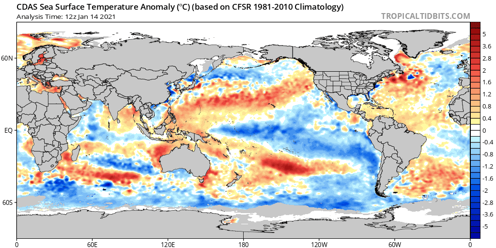
The atmospheric circulation associated with La Niña strengthened over the tropical Pacific Ocean during December. Low-level wind anomalies were easterly over the western to east-central tropical Pacific and upper-level wind anomalies were westerly across most of the tropical Pacific. Tropical convection was suppressed over the western and central Pacific and enhanced around the Philippines and parts of Indonesia. In addition, both the Southern Oscillation and Equatorial Southern Oscillation strengthened during December. Looking at the big picture, the coupled ocean-atmosphere system is consistent with a moderate-intensity, mature La Niña.
A majority of the long-term climate models in the IRI/Climate Prediction Center (CPC) plume predict La Niña to continue through the Northern Hemisphere winter (~95% chance for January-March). The CPC forecaster consensus is in line with the models and suggests La Niña will end and there will be a transition to ENSO-neutral conditions in the late spring 2021 (55% chance during April-June). However, the forecast uncertainty increases throughout the summer and fall, which is reflected by lower probabilities (less than ~50%) for La Niña and ENSO-neutral. CPC forecasters estimate similar probabilities of either La Niña or neutral for late summer and fall (around 40-45% chance) and much lower odds of El Niño. These lower odds are consistent with history.
If we look at a graph of the eventual fate of every first-year La Niña (meaning, the previous winter did not feature La Niña), we see how rare El Niño is the next winter.
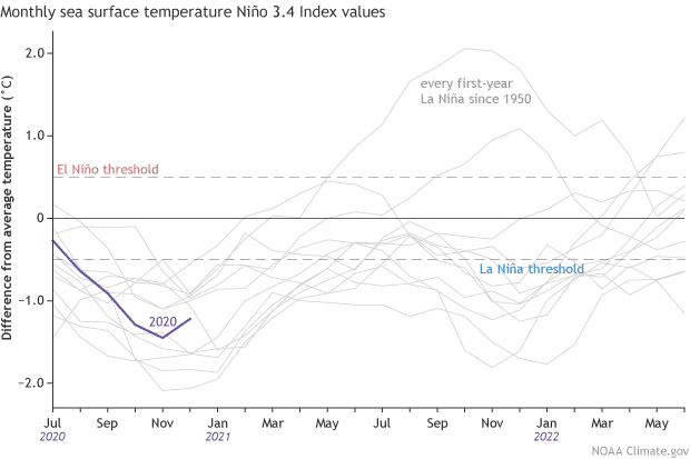
According to CPC, in our 1950-present record, a La Niña winter is more often followed by either neutral or weak La Niña conditions during the summer, with a re-development of La Niña the subsequent winter.
Of the 12 first year La Niña events, 8 were followed by La Niña the next winter, 2 by neutral, and 2 by El Niño. We’ll probably have to get through spring before forecasters can make a more confident prediction about next fall.
Stay tuned for more details of the ongoing La Niña.
Bob
Social Media