Mid-Week Weather and Tropics Update
AUG. 13, 2025
There will be an increased chance for scattered rain showers and thunderstorms across the Hill Country and Central Texas regions Wednesday afternoon and evening as remnant boundaries spread into the area out of North Texas. In addition, Wednesday’s analysis showed atmospheric moisture levels have gone up, compared to the past couple of days. As temperatures warm into the 90s Wednesday afternoon, scattered rain showers and thunderstorms are predicted to develop. The probability for rain at any given location will be near 40-50 percent. Some of the stronger thunderstorms may produce strong winds, with gusts up to 50 mph. Most of the rain and storms are expected to diminish around sunset as temperatures begin to cool. Rain amounts through Wednesday evening are forecast to generally average between a quarter and a half inch. However, there may be a few locally heavy downpours, with totals to near 2 inches possible.
Additional scattered showers and thunderstorms are forecast to develop across the region Thursday afternoon and evening. However, the rain is not expected to be as widespread as what is predicted for Wednesday. The probability for rain will be near 30 percent, with totals averaging around a quarter inch or less.
The probability for rain will decrease to just 20 percent on Friday.
For the coastal Plains region, there will be a 30 percent for mainly afternoon and evening showers and thunderstorms Wednesday through Friday due to an active sea breeze front. Expect spotty rain amounts totaling between 0.25 and 0.5 inches.
Southwestern Gulf Tropical Wave
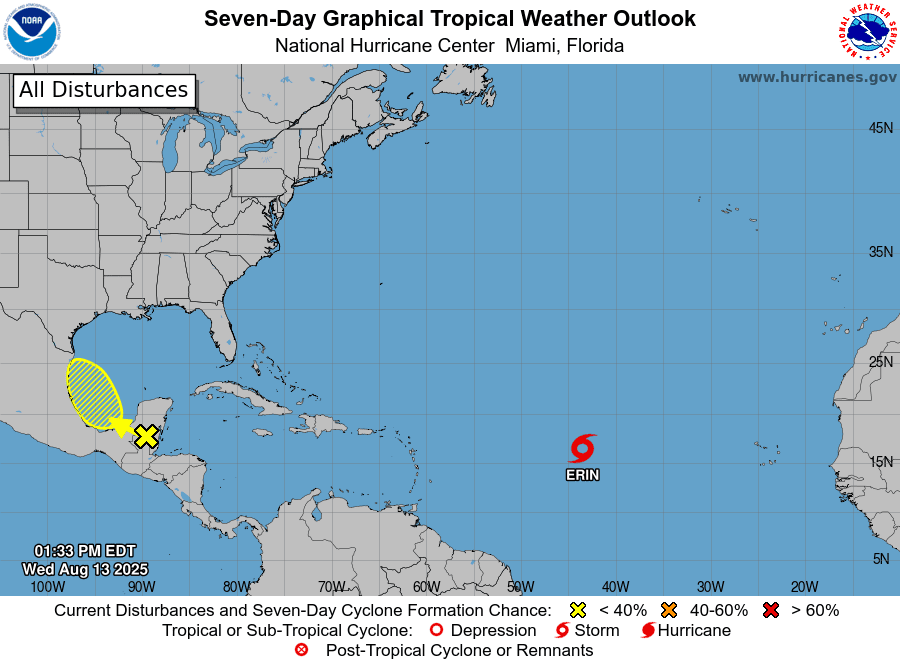
National Hurricane Center forecasters are closely monitoring a strong tropical wave currently located over the Yucatan Peninsula and southwestern Gulf. The wave is producing an area of disorganized showers and thunderstorms over the general area. The wave is forecast to move west across the Yucatan this afternoon and emerge over the southwestern Gulf/Bay of Campeche on Thursday. Forecasts call for the wave to push inland along the northeastern coast of Mexico, well to the south of Brownsville, late Friday.
There will be a small window Thursday afternoon through Friday where the system will be over water and some slow tropical development could take place. However, National Hurricane Center forecasters are giving this system just a 10 percent chance for tropical development over the next couple of days.
NOAA/Colorado State University 08-13-25 11:50 am CDT
The system is forecast to push an area of tropical moisture inland across northeastern Mexico and South Texas late Friday and through the weekend. The chance for rain Saturday and Sunday is predicted to increase to around 50 percent along the middle Texas coast and be around 30 percent across the Austin/Central Texas and Hill Country regions. Weekend rain amounts are predicted to generally average less than a half inch.
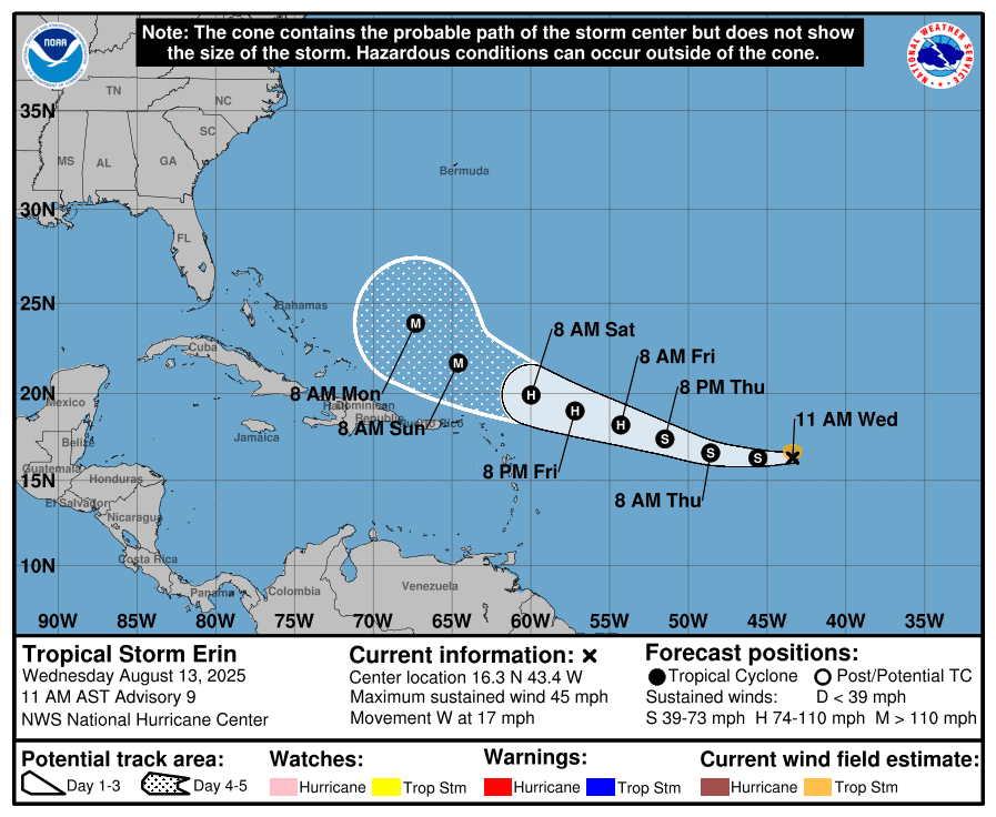
Tropical Storm Erin
For the past couple of days, Tropical Storm Erin has been struggling against dry air and a generally stable environment across the central tropical Atlantic. Erin is racing to the west at a rather fast pace, and this is also likely contributing to the system’s lack of organization.
As of 9 am CDT Wednesday, Erin was centered about 1305 miles east of the northern Leeward Islands. Erin was moving toward the west near 17 mph. This general motion is expected to continue into Thursday, with a west-northwestward motion beginning Thursday night and continuing into the weekend. Maximum sustained winds were near 45 mph, with higher gusts. Gradual strengthening is forecast to begin late Wednesday or Wednesday night, and Erin is expected to become a hurricane by Friday.
As Erin moves westward, conditions will gradually become better for organization and intensification as the system moves over warmer sea surface temperatures. On the forecast track, the center of Erin is likely to move near or just north of the northern Leeward Islands over the weekend as it tracks through a weakness between two high pressure ridges.
While there is significant spread among the various forecast models on the trajectory of Erin, nearly all of the forecast guidance keeps Erin well offshore of the U.S. East Coast.
Bob
This page was updated Wednesday afternoon. For the most up to date weather information, please consult the National Weather Service http://weather.gov/ewx http://weather.gov/hgx http://weather.gov/sjt
Social Media