Mostly Sunny, Dry, and Hot Weather Expected for the Week
AUG. 4, 2025
A complex of rain and thunderstorms moving southeast out of North Texas spread across the Hill Country and the Interstate 35 corridor Monday morning and the coastal area around midday. The storms produced very low totals of rain across the Hill Country. As the storms spread further to the southeast, totals trended a bit heavier across the southern counties of Central Texas and the middle Texas coast. Several spots across Fayette, Colorado, and Lavaca Counties recorded totals close to an inch.
Behind the complex, there will be a slight chance (a 20 percent chance) for a few scattered thunderstorms across the Hill Country and Central Texas regions Monday afternoon and evening. Across the coastal region, showers and a few isolated thunderstorms look to continue through Monday evening. The main concerns from any developing afternoon thunderstorms will be strong downburst winds with gusts to near 40 mph, and isolated heavy downpours. No rain is forecast Monday night.
High temperatures Monday will generally be in the low and mid-90s, with low and mid-80s towards the coast.
A large ridge of high pressure currently located over northern Mexico and the Desert Southwest is predicted to expand east across Texas Tuesday, and remain over the state through the end of the week and the upcoming weekend. The ridge will cause a mostly sunny, hot, and rain-free weather pattern the remainder of the week and this weekend. The coastal region may see a couple of isolated showers each day along the sea breeze front, but rain amounts, if any, should be quite low.
High temperatures Tuesday through Sunday are forecast to generally be in the mid and upper 90s across the Hill Country, the upper 90s to 100 degrees across Central Texas, and the mid-90s across the coastal plains.
The outlook for next week shows few changes as Texas remains on the eastern periphery of the strong ridge of high pressure. Little change in the temperature is expected, with highs staying mostly in the mid and upper 90s.
Tropical Weather Outlook
Weather conditions have become more active across the tropical Atlantic over the past couple of days, but none of this activity poses a threat to Texas or the western Gulf of Mexico.
Off the Southeastern United States, a broad area of low pressure is forecast to develop in a day or two several hundred miles off the coast of the southeastern United States. Some gradual development of this system will be possible during the middle or latter portion of this week as the system moves slowly westward to northwestward. NHC forecasters are giving this system a 30 percent chance for tropical development over the next seven days.
In the eastern tropical Atlantic, a tropical wave located just off the west coast of Africa is currently producing minimal shower activity. As the wave moves west-northwestward over the next few days, environmental conditions are forecast to become favorable for gradual development. A tropical depression could form by the latter portion of this week as the system continues moving generally west-northwestward across the central tropical Atlantic. Most forecasts call this system to eventually turn north into the central Atlantic, but this is far from certain.
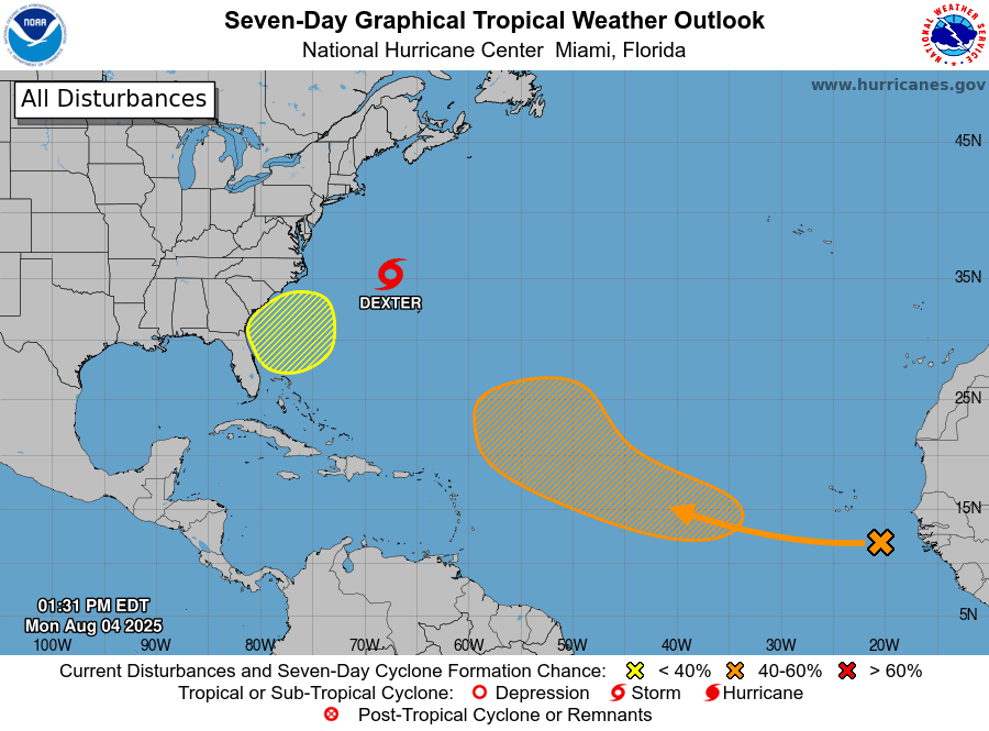
NOAA/Colorado State University/RAMMB 08-04-25 12:30 pm CDT
Morning Sky Show
Set your alarm for dawn. The two brightest planets in the solar system are converging for a close encounter in the morning twilight sky. The planets Venus and Jupiter Venus have become quite close inside the perimeter of the constellation Gemini. This is where the two planets will remain for the rest of August. The alignment is about to get much tighter and considerably more beautiful. Every morning this week, Jupiter and Venus will draw closer together until on Aug. 11-13, they will be less than 1 degree apart. Wake up early and enjoy the show!
Bob
This forecast was prepared Monday afternoon. For the most updated weather forecast data, please consult the National Weather Service.
Social Media