Rain and Possible Severe Storms Friday. Another Period of Storms Expected Next Week
May 2, 2025
We’re looking at an active afternoon and evening of weather across the region, with one of the highest potentials for widespread severe weather we’ve seen in quite a while. Everyone should be weather aware today, and have multiple paths to receive warnings from the National Weather Service and local media.
Friday’s analysis showed a moist and moderately unstable air mass in place across Central and South Texas. Warming temperatures this afternoon along with a leftover boundary from Thursday’s storms are expected to help initiate the development of showers and thunderstorms across the area by early afternoon. In addition, a cold front currently stretching across North and Northwest Texas is forecast to push southeast and move across the Hill Country and Central Texas regions this afternoon and evening, and the coastal region toward midnight Friday night. Widespread showers and thunderstorms are forecast to develop ahead of and along the cold front as it spreads to the south.
Many of today’s storms are forecast to quickly become strong to severe. The stronger storms may produce severe hail to near 3 inches in diameter and strong wind gusts to near 70 mph. In addition, a couple of isolated tornadoes cannot be totally ruled out.
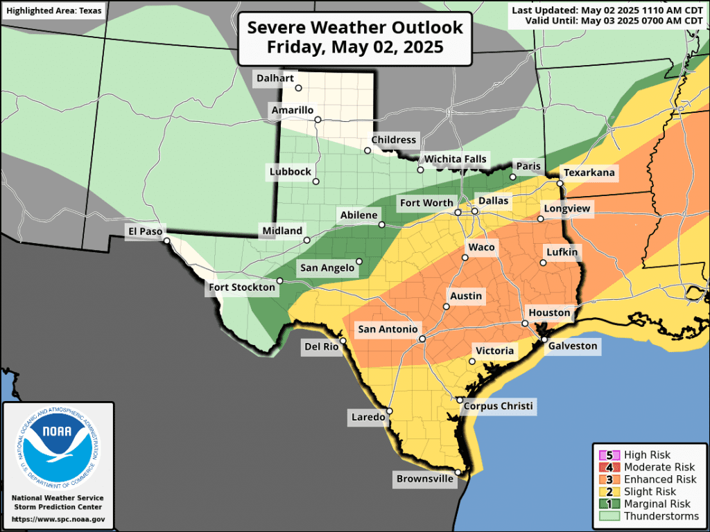
The Storm Prediction Center has placed most of the area under an Enhanced Risk for severe thunderstorms Friday afternoon through Friday night. This is a 3 out of 5 risk; something we don’t see all that often in Central Texas.
A fairly widespread coverage of rain is forecast Friday afternoon into Friday night. Given the slow moving nature of the frontal boundary along with the potential for storms and storm clusters to repeatedly move over the same area, significant totals of rain will be possible. The National Weather Service’s rainfall forecast calls for widespread totals of 1-2 inches across the region. Several pockets of 2-3 inch totals will be possible.
NWS Rainfall Forecast for the Period 7 pm Friday through 7 am Sunday:
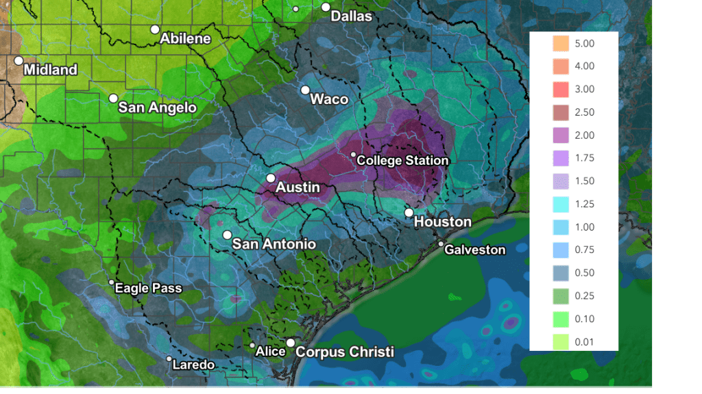
Forecasts call for the rains to taper off across the Hill Country by about midnight Friday night and across Central Texas by about 3 am Saturday. The rain and storms are forecast to taper off across the coastal region shortly after sunrise Saturday.
Cooler, sunny, and dry weather is forecast Saturday through Sunday as a high pressure builds over Texas behind the cold front.
- High temperatures Saturday and Sunday are forecast to be in the mid and upper 70s across the Hill Country and Central Texas regions, and be around 80 degrees towards the coast
- Lows Saturday morning will range from the upper 50s across the Hill Country, to the mid-60s towards the coast
- Lows Sunday mornings will include the upper 40s to low 50s across the Hill Country, the low and mid-50s across Central Texas, and the upper 50s across the coastal area
- Lows Monday morning will generally be in the upper 50s to low 60s
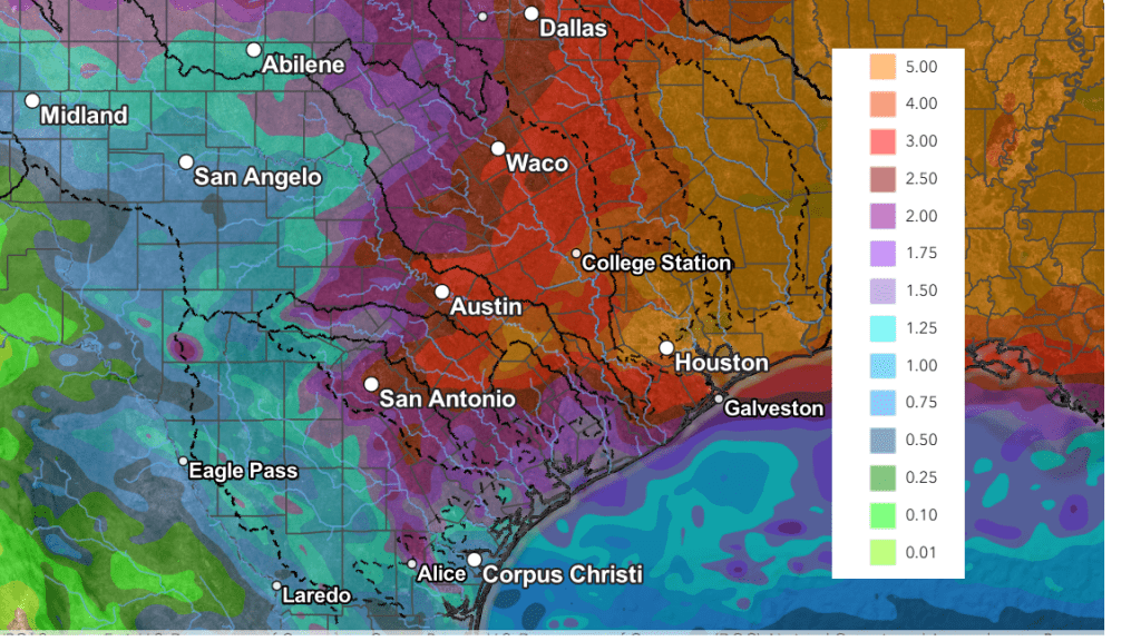
Another period of rain and thunderstorms is forecast to take shape next Tuesday through Thursday when a trough of low pressure tracks from the Four Corners region on Monday to the southern Plains states on Wednesday. Several waves of low pressure are predicted to spread east across Texas ahead of the parent trough, producing rounds of rain showers and thunderstorms. As of now, Tuesday is expected to have the highest potential for severe thunderstorms as the dry line pushes east out of West Texas.
This period could potentially be fairly wet. Forecasts are calling for widespread totals of 1-3 inches over the area between Tuesday and late Thursday.
Here’s a look at the National Weather Service’s forecast for rainfall through 7 pm next Friday, which incorporates Friday’s rain together with next week’s rain.
High temperatures next week are forecast to generally be in the low and mid-80s.
Dry weather is forecast next Friday, continuing into next weekend.
Have a good weekend!
Bob
Social Media