Rounds of Showers and Thunderstorms Expected through Thursday
May 5, 2025
An wet and unsettled weather pattern is forecast through Thursday as a large area of low pressure slowly lifts to the north out of the Desert Southwest. Out ahead of the primary trough Monday, a small wave of low pressure has been tracking north across Central Texas. This system caused the development of rain showers and thunderstorms across a large part of Central Texas around midday. Some of the thunderstorms produced large hail across parts of Bastrop and Williamson Counties. Meanwhile, a second complex of rain and thunderstorms has been moving from west to east across North Texas. Some of this activity has extended as far south as Abilene and Brownwood.
This afternoon through Monday night, additional showers and scattered thunderstorms can be expected across the entire region as the atmosphere grows increasingly moist and unstable in advance of the trough moving out of New Mexico. The probability for occasional rain and thunderstorms Monday afternoon will be near 50 percent.
Attention will turn to Monday evening when large clusters of thunderstorms are forecast to develop across West Texas and the Rio Grande Plains. The area of thunderstorms are predicted to move to the east and spread across the Hill Country and Central Texas regions Monday evening into Monday night. Forecasts then call for a second round of scattered thunderstorms to develop across the western Hill Country along a Pacific cold front before daybreak Tuesday. This area of thunderstorms is predicted to spread east across the Hill Country, Central Texas, and coastal regions Monday morning into Monday afternoon.
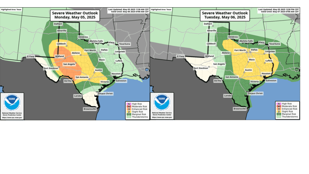
Moderate to locally strong atmospheric instability is forecast to be in place this afternoon, tonight, and Tuesday. Because of this there will be a good potential for some of the storms to become strong to severe. Large to very large hail and damaging wind gusts will be the primary severe weather threats. However, a couple of isolated tornadoes cannot be ruled out.
The Storm Prediction Center has placed the Hill Country, Central Texas, and coastal regions under a Slight Risk, or 2 out of 5 risk, for severe thunderstorms this afternoon, tonight, and Tuesday.
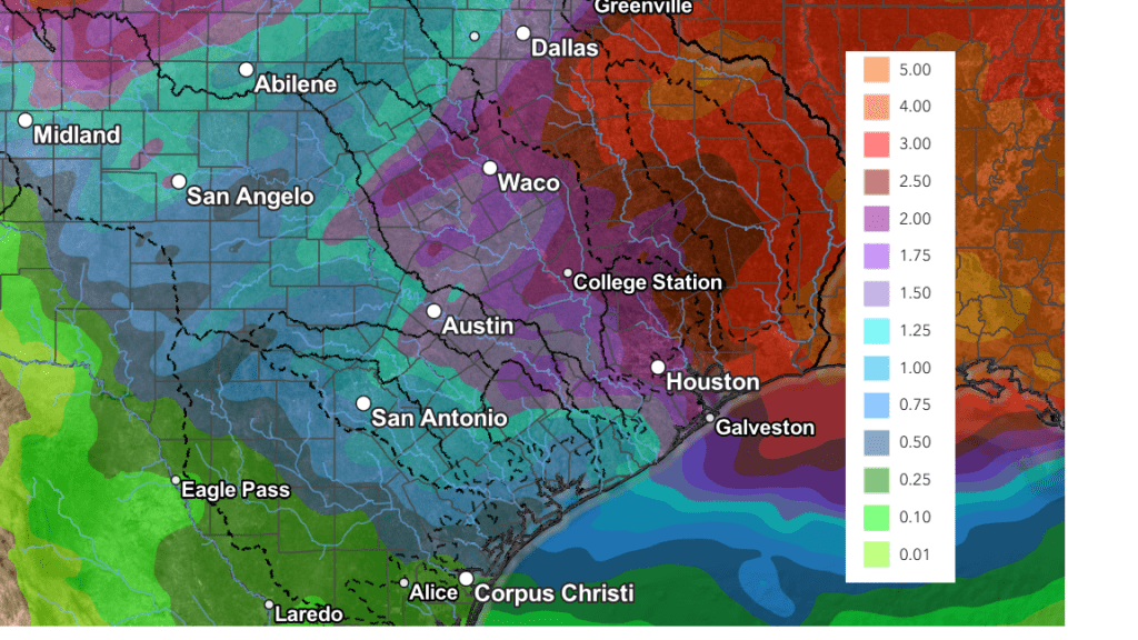
The rain and thunderstorms spreading across the area Monday afternoon through Tuesday are expected to cause moderate to locally heavy rain and at least some risk for flash flooding. Rain amounts through Tuesday evening are forecast to generally average between 1 and 2 inches, along with isolated heavier totals.
The area of rain and thunderstorms is predicted to push east of our region Tuesday evening, with a break in the rain developing Tuesday evening and Tuesday night.
For Wednesday, there will be a 20-30 percent chance for more scattered rain showers and thunderstorms across the Hill Country and Central Texas regions. Across the coastal region, a good chance for rain showers and thunderstorms looks to continue as Tuesday’s cold front slows down and nearly stalls over the area. The probability for rain will be near 80 percent.
Thursday will see a 30-40 percent chance for rain showers and scattered thunderstorms across the region as one final wave of low pressure moves across Texas. Rain amounts are not expected to be all that heavy.
Rain amounts through Thursday are forecast generally average between 1 and 2 inches, with the majority of the rain falling Monday afternoon through Tuesday afternoon.
NWS Rainfall Forecast Valid through 7 pm Thursday:
Mostly sunny and dry weather is forecast Friday and through the upcoming weekend. Expect highs in the low and mid-80s, with lows in the low 60s.
The outlook for next week calls for dry conditions and warmer temperatures. Expect highs to warm into the low to mid-90s by the middle of next week.
Bob
Social Media