Spotty Showers Possible Tuesday and Wednesday. Otherwise, Expect More Sunshine and Heat
June 23, 2025
It’s now looking and feeling a lot like summer. There has been very little day to day change in the weather over the past week and this persistent pattern looks to continue for at least the next couple of weeks. Unfortunately, no significant or heavy rain is on the horizon. It appears the summer doldrums have arrived.
The main weather feature affecting our region this week will be a large ridge of high pressure in the middle and upper atmosphere centered over the Ohio Valley. Texas will be on the western periphery of the ridge. Close enough for continued hot temperatures, but far enough away to allow for a few spotty rain showers and isolated thunderstorms—mainly for areas east of Interstate 35. The first half of the week will likely contain the best chances for spotty showers, with rain chances diminishing late week and this weekend.
For Monday afternoon and Monday night
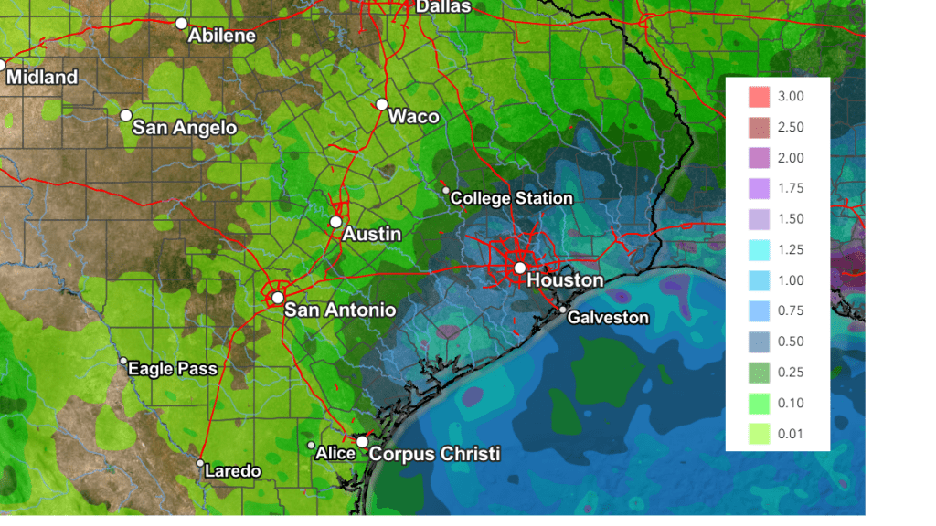
There will be a 30 percent chance for isolated rain showers and thunderstorms for areas near and south of Interstate 10. A less than 20 percent chance for spotty showers will extend inland to the Interstate 35 corridor. Rain amounts, if any, should average less than a tenth of an inch. Mostly sunny and hot weather will continue, with highs in the mid-90s. Expect a southerly wind at 10-15 mph with occasional gusts to 25 mph.
For Tuesday and Wednesday
A more widespread coverage of spotty rain showers and isolated thunderstorms is forecast across Central Texas and the middle Texas coast as moisture levels increase off the Gulf. Forecasts call for a small, non-tropical area of low pressure to track inland along the lower Texas/northern Mexican coast on Wednesday. This system is expected to pull and an enhanced area of tropical moisture inland, resulting the development of spotty rain showers and isolated thunderstorms. The probability for rain will range from 50 percent across the coastal plains, to just 20 percent across the I-35 corridor. Few if any of the showers are expected to reach into the Hill Country. Spotty totals to around a tenth of an inch are forecast on both days. High temperatures are forecast to generally be in the mid-90s.
Thursday through the Upcoming Weekend
Mostly sunny and generally dry weather is forecast as the ridge of high pressure over the Ohio Valley slowly expands back to the west and southwest. While a spotty shower or two can’t be ruled out near the coast, no rain is forecast elsewhere. The temperature is predicted to warm slightly, with daily highs generally in the mid and upper 90s. Low 90s are forecast across the coastal plains.
NWS Rainfall Forecast Valid through 7 pm Monday, 6/30
Next Week
Sunny and hot weather is forecast to continue across the region as the center of the ridge of high pressure sets up near the Four Corners. A few spotty rain showers will be possible near the coast, but generally dry weather is forecast elsewhere. With the ridge getting a little stronger, slightly hotter temperatures can be expected. Daily high temperatures are forecast to be in the mid and upper 90s across the Hill Country, the upper 90s across Central Texas, and the mid-90s near the coast. There are indications of daily high temperatures across Central Texas reaching 100 degrees beginning around July 5th.
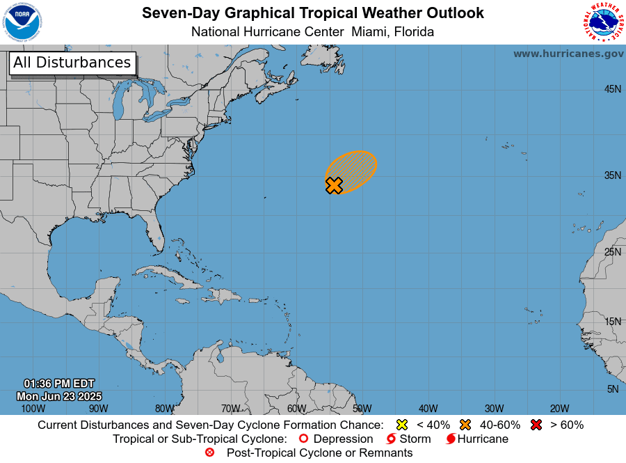
Tropical Weather Outlook
Weather conditions remain quiet across the tropical Atlantic, the Caribbean Sea, and the Gulf of Mexico.
Out over the central subtropical Atlantic, A low pressure system located more than 600 miles east-northeast of Bermuda is producing gale-force winds (according to satellite data. However, the shower and thunderstorm activity associated with the low remains disorganized. Environmental conditions are marginally favorable for further development, and an increase in thunderstorm activity could result in the formation of a short-lived tropical depression or tropical storm Monday afternoon or Monday night. By Tuesday, this system is expected to encounter unfavorable environmental conditions, ending its opportunity for development. The system is forecast to move northeastward around 10 to 15 mph, remaining over the open central Atlantic.
NHC forecasters are giving this system a medium, 60 percent chance, for tropical development over the next seven days.
Have a great week!
Bob
Social Media