Temperatures are going to feel more like a typical April or May rather than the period before Christmas on Thursday and Friday. In fact, near-record to record warm temperatures are forecast across the region.
The cool air mass which moved into the area early Monday quickly shifted to the east Tuesday afternoon, allowing for a return of warm, southerly breezes. Thursday and Friday, gusty southwesterly breezes of 10-15 mph with gusts to 25 mph are forecast to develop due to a strong pressure gradient. These southwesterly breezes will be down sloping—flowing from the plateaus of Mexico into the Hill Country and Central Texas. The sinking air will combine with abundant afternoon sunshine to push temperatures well into the 80s. On Friday, the warm temperatures will get an extra boost from a little compressional heating ahead of a cold front.
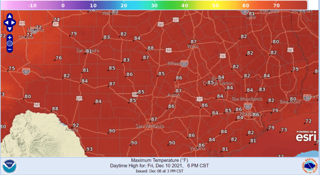
- High temperatures Thursday are predicted to generally reach the low to mid-80s.
- Low temperatures Friday morning will range from near 60 degrees across the Hill Country, to the mid-60s across Central Texas, to the low 70s near the coast.
- High temperatures Friday are predicted to reach the low and mid-80s across the Hill Country and coastal plains regions. For the Austin and Central Texas region, the temperature is expected to warm to the mid and upper 80s.
Relief from the unseasonably warm temperatures will arrive Friday night into early Saturday morning as strong cold front sweeps south across the area. A narrow band of rain showers and thunderstorms is forecast to develop along the front—generally from just east of the I-35 corridor, southeast to the coast. Some of the thunderstorms could become strong to severe. The Storm Prediction Center has placed Fayette, Colorado, Wharton and Matagorda Counties under a Marginal Risk (1 out of 5 risk) for severe thunderstorms. The primary severe weather threats will be damaging downburst winds and possibly one or two isolated tornadoes. Rain amounts should average around a half inch or less.
Clouds will clear Saturday morning. Breezy and much cooler weather will follow Saturday afternoon, with high temperatures around 58-60 degrees.
A freeze is forecast for the Hill Country and parts of Central Texas Saturday night. Lows Sunday morning are predicted to be in the upper 20s to low 30s across the Hill Country and in the low to mid-30s across Central Texas. Lows across the coastal plains region are forecast to be around 40 degrees.
Sunny weather will continue Sunday, with high temperatures in the low 60s.
Bob
Social Media