Stagnant Weather Pattern to Bring More Sunny, Dry, and Warm Weather
SEPT. 12, 2025
An unusually tranquil and warm late summer weather pattern continues across Central and South Texas. Unfortunately, the cooler, pleasant mornings we saw earlier this week have been replaced by warmer and more humid air thanks to southeasterly breezes off the Gulf.
No significant changes to the current weather pattern are forecast to take place this weekend or next week.
Friday’s analysis showed a large ridge of high pressure stretching from northern Mexico, north across Texas and up to the middle Mississippi Valley. This ridge is responsible for the current sunny and warm weather pattern across the state. Forecasts call for the ridge to weaken slightly this weekend, then restrengthen early next week and remain over Texas through late next week. With the ridge holding over our area, more sunny, dry, and warm weather is predicted for the next several days. Do note a few isolated sea breeze-related rain showers will be possible each afternoon across the coastal Plains region next week. Rainfall, if any, will be very spotty in nature.
Little to no change in the temperature is forecast over the next week thanks to the persistent ridge of high-pressure overhead.
- Daily high temperatures over the next week will include the low 90s across the Hill Country, the low to mid-90s across the coastal plains, and the middle 90s across the Austin/Central Texas area
- Daily low temperatures over the next week will include the upper 60s across the Hill Country, near 70 degrees across the Austin/Central Texas area, and in the low 70s across the coastal region
Looking out further to next weekend and the week of September 22nd, forecast solutions call for the ridge of high pressure over Texas to finally weaken while it shifts slowly to the southwest. This should result in a drop of about 2-3 degrees in our high temperatures. In addition, we may see the development of a few widely scattered rain showers for areas along and east of Interstate 35. But overall, no significant change in weather pattern is forecast at this time.
Tropical Weather Update
Weather conditions remain unusually quiet across the Gulf, the Caribbean Sea, and the tropical Atlantic. Many forecasters attribute these quiet conditions to widespread sinking air, unusually high sea-level pressure readings, and an unusually strong Azores high pressure system.
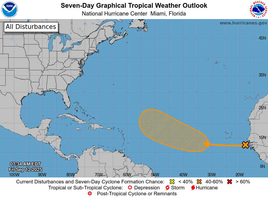
National Hurricane Center forecasters are closely monitoring a tropical wave that is located near the west coast of Africa. The wave is currently producing clouds and disorganized showers and thunderstorms over the far eastern Atlantic. According to the NHC, environmental conditions appear conducive for some gradual development of this system over the next several days and a tropical depression could form by the middle next week as the system moves westward to west-northwestward at 10 to 15 mph over the eastern and central tropical Atlantic.
NHC forecasters are giving this system a 40 percent chance for tropical development over the next seven days. Elsewhere, tropical cyclone development is not expected.
Weak La Nina Development Possible in the Next Couple of Months
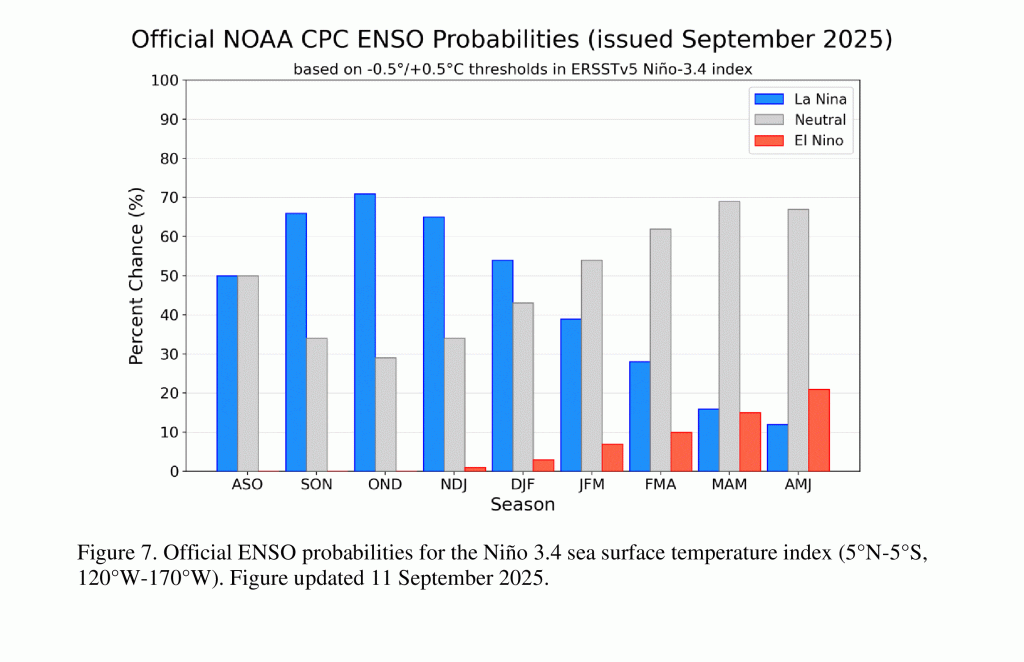
Climate Prediction Center forecasters issued their monthly update Thursday and stated they expect a weak La Niña to emerge this fall and persist through the upcoming winter. CPC’s forecast showed a 71% chance for the development of La Niña between October and December 2025. Thereafter, the probability for La Niña decreases to 54% between December 2025 and February 2026. A return to ENSO-neutral conditions is forecast for next spring.
The forecast development of La Niña is significant since most La Niña’s have historically brought Texas a drier and milder than-normal weather pattern over the late fall and winter periods. More details on the winter outlook in the next few weeks.
Have a great weekend!
Bob
For the latest weather information, please consult the National Weather Service:
Social Media