Sunday Weather Update
July 13, 2025
A large area of rain and thunderstorms took shape across the Concho Valley and northern Hill Country late Saturday night. The complex of rain remained nearly stationary for several hours and produced totals of 7-9 inches across western Lampasas and southern San Saba Counties, and widespread 3-4 inch totals between Menard to just north of Llano. As of 11 am, the area of moderate to heavy rain had spread south and southeast to cover most of the Hill Country.
High resolution forecasts call for the complex of storms to slowly propagate to the south and southeast late Sunday morning through Sunday afternoon. There are indications the intensity of the rain may come down a bit some through the afternoon, but rain rates of at least 1-2 inches per hour will still be possible. Forecasts call for the rain and storms to reach the Interstate 35 corridor midday to early Sunday afternoon and the area between Bastrop and La Grange mid to late afternoon. The area of rain and storms is forecast to continue into Sunday evening, then diminish. Meanwhile, lighter rains are forecast to persist across the Hill Country through at least mid-afternoon, then diminish. The complex of storms is not predicted to reach the middle Texas coast. However, there will still be a 50 percent chance for scattered showers and thunderstorms through Sunday evening.
With the rain falling on soils that are still very wet from recent rains, this additional rain will quickly runoff and could cause flash flooding. The National Weather Service has posted a Flood Watch for all of the Hill Country and the Intestate 35 corridor, from Temple to San Antonio, (including the Austin metro) through 7 pm Sunday.
In general, additional rain amounts Sunday afternoon through Sunday night across the Hill Country and Central Texas regions are forecast to average between 2 and 4 inches, with isolated totals of 5-7 inches possible. Totals across the coastal plains are forecast to average around a half inch.
The outlook for Monday and Tuesday calls for a slight chance for scattered afternoon showers and thunderstorms across the entire region. Rain amounts are forecast to average around a quarter inch or less. Mostly sunny and dry weather is predicted for Wednesday through Friday.
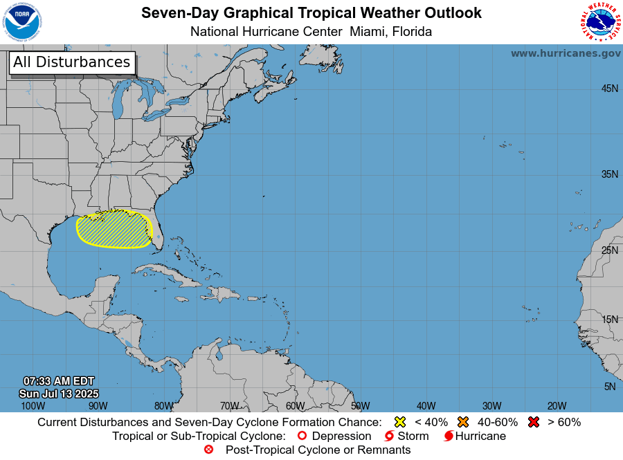
Watching the Northern Gulf
National Hurricane Center forecasters indicate a trough of low pressure is likely to form near the southeastern
U.S. coast during the next day or two and then move westward across Florida into the northeastern Gulf by Tuesday. Environmental conditions could support some gradual development of this system during the middle to late part of this week while it moves westward over the northeastern and north-central portions of the Gulf. There is some probabilities in the various ensemble guidance suggesting slow development, but where any actual surface low may form is uncertain. This is something that definitely needs to be watched closely over the next several days.
The National Hurricane Center is currently giving this disturbance a 20 percent chance for tropical development over the next seven days.
Bob
Social Media