Fall-like weather returned to Texas Sunday following the passage of a strong cold front. As the strong winds diminished Sunday evening, conditions became ideal for cold temperatures to develop. Minimum temperatures early Monday morning were either the coldest or close to the coldest recorded so far this autumn. Freezing temperatures were recorded across a large part of the Hill Country and also at several locations across Central Texas. Austin-Bergstrom International Airport recorded its first freezing temperature of fall with a low temperature of 32 degrees. According to LCRA’s Hydromet, low temperatures across the Hill Country and Central Texas were generally in the upper 20s to mid-30s. Across the middle Texas coast, low temperature ranged from the low 40s along the Interstate 10 corridor to the low 50s at the coast. LCRA’s lowest gauged temperature was 25 degrees at gauges located in eastern Coleman County and northwestern Kimble County.
Sunny and dry weather will be in place throughout the week as our region remains under the influence of stable ridge of high pressure in the upper atmosphere. At the surface, a dome of Canadian high pressure will be hold in place through Tuesday then move off to the east on Wednesday, causing a return of warmer and a bit more humid weather for late week.
- High temperatures this afternoon and Tuesday will be in the low and mid-70s.
- High temperatures Wednesday will be in the upper 70s, warming close to 80-82 degrees Thursday and Friday.
- High temperatures Saturday will be in the low 80s.
- Low temperatures Tuesday morning will be similar to those observed early Monday morning. Lows will range from the low and mid-30s across the Hill Country to the mid-40s across the coastal plains.
- Low temperatures Wednesday morning will range from near 40 degrees across the Hill Country to around 50 degrees near the coast.
- Lows Thursday and Friday mornings will be in the 50s.
- Lows Saturday morning will range from the 50s across the Hill Country to the low 60s near the coast.
A significant change in the weather pattern is predicted to take place next Sunday when another strong cold front pushes south through our area. This time, conditions are shaping up to be a bit more favorable for the development of rain showers and even a few thunderstorms along and behind the cold front Sunday afternoon through early Monday morning. Unlike with most of the recent cold fronts, the combination of significant low-level moisture and a favorable upper-level jet stream is expected to cause the development of showers and isolated thunderstorms. The chance for rain will diminish from west to east early Monday morning when drier and cooler air spreads in behind the cold front. Rain amounts are forecast to generally average between 0.5 and 1 inch.
Sunny and dry weather is forecast next Monday afternoon and Tuesday. High temperatures Monday and Tuesday will be in the 60s while lows next Monday and Tuesday mornings temperatures will be in the 40s.
Long-range forecasts call for a slight chance for rain to develop next Wednesday when a trough of low pressure tracks east across the southern Plains states. Rain amounts, if any, are expected to be low.
The outlook for Thanksgiving Day and next Friday calls for sunny, dry and mild weather with high temperatures in the 70s. I will caution there is still some uncertainty in the outlook for late next week.
Long-range forecast solutions are still not showing a pattern that would be favorable for delivering arctic air into our region through the end of November.
Tropical Weather Outlook
…Category 5 Hurricane Iota is Headed for Nicaragua and is Expected to bring Catastrophic Winds and Torrential Rains to Central America…
Hurricane Iota was upgraded to a category 5 hurricane Monday morning. Iota is a very impressive hurricane, especially for this late in the year, with a distinct, warm eye as seen on satellite imagery. Iota is the latest category 5 hurricane on record for the Atlantic basin.
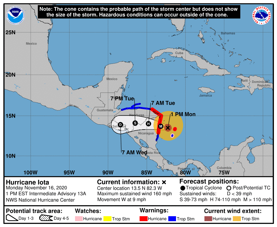
As of noon CST, the eye of Hurricane Iota was located by an Air Force Reserve Hurricane Hunter aircraft about 80 miles east-southeast of Puerto Cabezas, Nicaragua. Iota was moving toward the west near 9 mph, and this general motion is forecast through landfall. After landfall, a westward to west-southwestward motion is expected. On the forecast track, the core of Iota will make landfall northeastern Nicaragua tonight, and will dissipate over central America by Wednesday.
Maximum sustained winds remain near an incredible 160 mph with higher gusts. Iota is forecast to continue to be a catastrophic category 5 hurricane when it approaches Central America tonight, and rapid weakening is expected after landfall.
This is a catastrophic situation unfolding for northeastern Nicaragua, with an extreme storm surge of 15-20 ft forecast along with destructive winds and potentially 30 inches of rainfall. It is exacerbated by the fact that Iota should make landfall in almost the exact same location that category 4 Hurricane Eta did about two weeks ago.
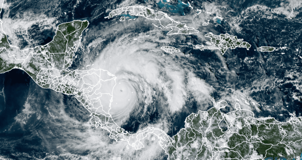
RAMMB-CIRA-Colorado State University 11/16/2020 1:30 pm CST
And if that wasn’t enough, forecasters are monitoring the central and southwestern Caribbean Sea where a new area of low pressure could form in a couple of days. Environmental conditions should favor some subsequent development, and a tropical depression could form by the end of the week while the system moves slowly westward or west-southwestward across the southwestern Caribbean Sea. NHC forecasters are giving this system a 40 percent chance for development over the next 5 days.
Peak of the Leonid Meteor Shower and the ISS Returns to the Evening Sky this Week
Don’t forget the Leonid meteor shower is forecast to peak early Tuesday morning, November 17th. 15 to 20 meteors per hour are expected.
The International Space Station is returning for a view in the evening sky this week, with good opportunities to see the station each evening this week. In fact, there will be two opportunities to spot the station on Tuesday and Thursday evenings.
To see where and when to watch for your particular location, check out the NASA’s Spot the Station website https://spotthestation.nasa.gov/home.cfm
Bob
Social Media