Sunny and Warm through Late Week. Next Chance for Rain Expected to Develop this Weekend
SEPT. 2, 2025
Although the calendar has changed to September, summer’s heat won’t be going away anytime soon. Over the long holiday weekend, a weak cold front pressed south across the area, bringing some hit and miss rain showers and thunderstorms. The highest rain amounts from the weekend rain occurred across Gillespie, Mason, and eastern Burnet Counties, were totals of 2-3 inches were observed. The rain was more miss than hit for areas along and east of Interstate 35. Here, there were some spotty totals of 0.25 to 0.5 inches.
Tuesday’s weather maps showed the weekend cold front has stalled over South Texas, between Eagle Pass and Corpus Christi. The front helped to bring in some drier and just slightly cooler air. A couple of spotty rain showers will be possible for areas south of Interstate 10 Tuesday afternoon. Otherwise, sunny and dry weather is forecast across the region Tuesday through Wednesday.
- High temperatures Tuesday are forecast to be in the low and mid-90s
- High temperatures Wednesday are predicted to generally be in the mid-90s.
Forecasts call for drier air to spread south across our area late Wednesday into Thursday, which should help nighttime temperatures to cool a few more degrees. At the same time, this dry air is expected to heat up close to the century mark for Thursday and Friday. Sunny weather will continue.
- Lows Thursday morning will include the mid-60s across the Hill Country, the upper 60s across Central Texas, and the low 70s across the coastal plains
- High temperatures Thursday are forecast to be near 98-100 degrees across the Hill Country and Central Texas regions, and in the upper 90s across the coastal counties
- Lows Friday morning will range from upper 60s across the Hill Country, to the low 70s near the coast
- High temperatures Friday will again be near 98-100 degrees across the Hill Country and Central Texas regions, and in the mid to upper 90s near the coast
The weather pattern is forecast to change this weekend when Gulf moisture is drawn into the state ahead of a new cold front sinking to the south out of Oklahoma. Although the front is expected to stall over North Texas, moisture levels are expected to increase beginning late Saturday and continue into next week. The increased moisture is expected to bring an increasing chance for rain and scattered thunderstorms Sunday into Monday. As of now, the probability for rain is forecast to be 20 percent Saturday, near 50 percent Sunday and Monday, and near 30 percent Tuesday.
Forecasters will be closely following the progress of newly formed eastern Pacific Tropical Storm Lorena, which is forecast to turn inland over northwestern Mexico late Saturday into Sunday. Clouds and moisture from this system could enhance the moist pattern already in place across Central and South Texas and potentially set the stage for some significant totals of rain.
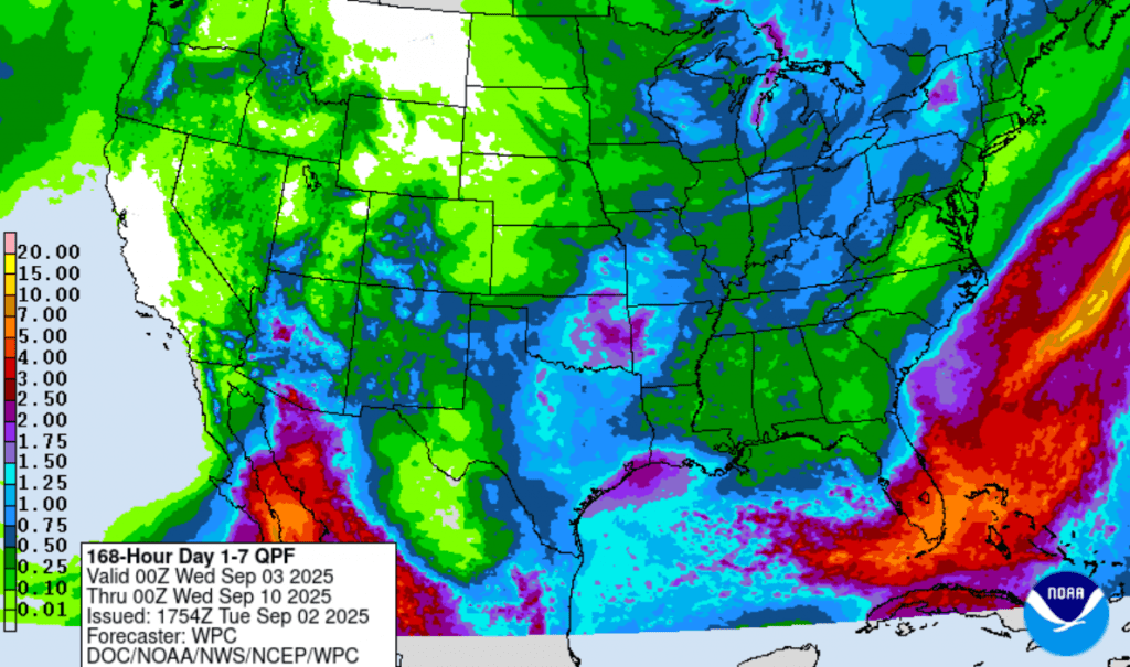
As of now, the Weather Prediction Center’s forecasted rain totals through next Tuesday evening call for widespread totals of 1-1.5 inches across the region. Keep in mind, these totals could change once we get a better handle on the influence from the tropical system.
NWS Rainfall Forecast Valid through next Tuesday at 7 pm:
Mostly sunny and dry weather is forecast for the middle and latter parts of next week. Expect high temperatures to be in the low and mid-90s.
Tropical Weather Outlook
National Hurricane Center forecasters are monitoring a tropical wave located over the far eastern tropical Atlantic, to the southwest of the Cabo Verde islands. This system is producing a large area of disorganized showers and thunderstorms. Environmental conditions remain conducive for gradual development of this system during the next several days, and a tropical depression is likely to form late this week or this weekend. This system is expected to initially move slowly westward, then gradually accelerate westward to west-northwestward at around 15 mph across the eastern and central tropical Atlantic into early next week.
NHC forecasters are giving this system a 70 percent chance for tropical development over the next seven days.
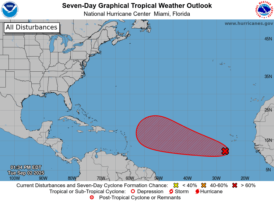
Elsewhere, conditions are quiet and additional tropical cyclone development is not expected over the next seven days.
Have a good week!
Bob
Social Media