…A Tropical Storm Watch has been posted for the Texas coast from Port Mansfield (near Raymondville) to High Island…
The strong tropical wave over the eastern Gulf of Mexico Wednesday organized into a tropical depression Wednesday evening. Thursday morning, satellite imagery indicated the depression was getting better organized, with a better-defined center beginning to show. At 2 pm CDT, the center of Tropical Depression Eight was located by an Air Force Reserve Hurricane Hunter aircraft over the west-central Gulf of Mexico, about 415 miles east-southeast of Port O’Connor. The depression was moving toward the west-northwest near 7 mph, and a west-northwestward to westward motion is expected to continue for the next couple of days. Maximum sustained winds are near 35 mph, with higher gusts. Slow strengthening is expected and the depression could become a tropical storm tonight or on Friday.
On the current forecast track, a the center of the depression is expected to move across the northwestern Gulf of Mexico today and Friday and make landfall as a tropical storm somewhere along the middle or lower Texas coast midday Saturday. The cone of uncertainty at landfall stretches from Port Mansfield to Freeport, with the center of the cone being near San Antonio Bay. The National Hurricane Center forecasts maximum sustained winds at landfall to be around 55 mph.
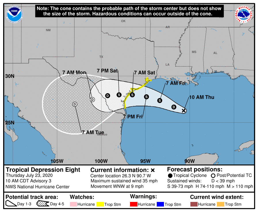
Once inland, the center of the system is forecast to continue tracking to the west, reaching a position southeast of San Antonio Saturday evening, just north of Laredo Sunday morning and over northeastern Mexico Monday morning.
Based on the latest forecast track, the tropical depression is expected to have a significant impact on the middle Texas coastal region, with lesser impacts expected across the Austin/Central Texas region and the Texas Hill Country.
Rainfall Forecast
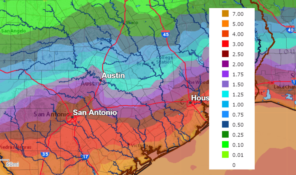
Showers and thunderstorms associated with the tropical depression/tropical storm are forecast to reach the middle Texas coast Friday afternoon. The rain is forecast to slowly spread inland to the west/northwest Friday night into Saturday morning. By midday Saturday, widespread rain showers and scattered thunderstorms are forecast to cover the middle Texas coast, all of Central Texas and a good portion of the Hill Country. A steady rain looks to continue across much of the region Saturday night through Sunday night. The heaviest rains are predicted to fall across the area generally to the south of Interstate 10, with lighter rains expected across Central Texas and the Hill Country. There will be a 40-50 percent chance for additional showers and thunderstorms across the area on Monday.
Rainfall forecasts for the period between this afternoon and Tuesday morning call for totals of 4-6 inches for locations generally along and south of US Highway 59 (Wharton and Matagorda Counties). Further inland, totals of 2-3 inches are forecast for the area between Smithville and Columbus. Totals of 1.5-2 inches are forecast around the Austin area. Across the Hill Country, totals are predicted to generally average between 1 and 1.5 inches. Do note that locally higher rain amounts will be possible—especially where any banding may set up. Flash flooding will be possible in these heavier rain areas.
NWS Rainfall Forecast for the Period 7 am Thursday through 7 am Tuesday
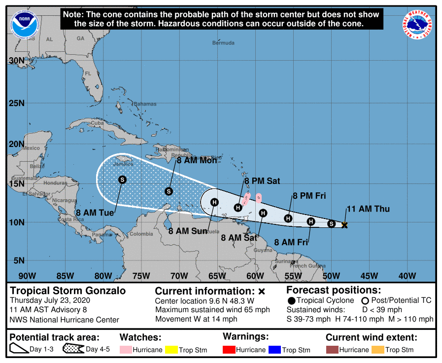
Tropical Storm Gonzalo
There haven’t been any significant changes with tropical storm Gonzalo since yesterday . As of 2 pm CDT, the center of Tropical Storm Gonzalo was located about 850 miles east of the southern Windward Islands. Gonzalo is moving toward the west near 14 mph. A westward to west-northwestward motion with an increase in forward speed is expected through the weekend. On the forecast track, the center of Gonzalo will approach the southern Windward Islands Friday night and move across the islands Saturday and Saturday evening. Maximum sustained winds are near 60 mph with higher gusts. Some strengthening is forecast during the next couple of days, and Gonzalo could become a hurricane on Friday.
Gonzalo faces an uncertain future. The majority global forecast model solutions continue to call for Gonzalo to weaken to a tropical storm early next week when it reaches the area south of Hispaniola and Jamaica. The modeling is split on whether the system dissipates or remains a weak system as it moves to the western Caribbean Sea the latter half of next week. We will need to keep a close watch on the progress and evolution of Gonzalo.
Bob
Social Media