Tropical Disturbance to Move Inland Friday Afternoon. A Chance for Showers Forecast through Saturday
AUG. 15, 2025
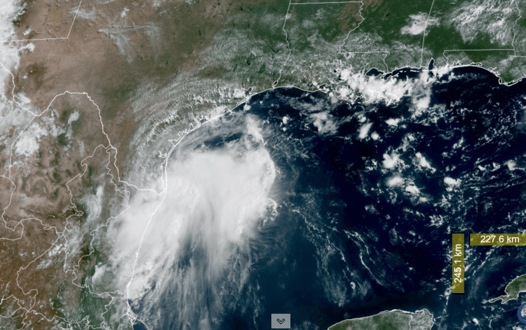
The National Hurricane Center continues to closely monitor the area of disturbed weather located off the coast of northeastern Mexico and southern Texas. An Air Force Reserve Hurricane Hunter aircraft investigated the system Friday morning. Wind data from the aircraft and Doppler radar data did not show the presence of a closed circulation and the trough axis associated with the disturbance was closer to the coast than previously estimated. Therefore, the possibility of the system developing into an organized tropical depression has decreased significantly since the system only has a few hours left over water. NHC has reduced the probability for tropical development from 50 percent, down to just 20 percent.
NOAA/Colorado State University 08-15-25 10:50 am CDT
The disturbance is moving to the northwest and is forecast to move inland over southern Texas, the north of Brownsville, Friday afternoon. Regardless of development, the system is forecast to bring a surge of tropical moisture into South Texas beginning Friday afternoon, with the moisture remaining in place through Saturday night.
For Friday afternoon and Friday night, scattered showers and thunderstorms are forecast to spread northwest from the Gulf across the coastal plains and possibly into parts of Central Texas. The probability for rain will range from 50 percent across the coastal plains, to just 20 percent across Central Texas.
Saturday through Saturday night, a more widespread coverage of scattered rain showers and thunderstorms is predicted for the entire region as the area of moisture spreads further inland. The probability for rain will be near 50 percent across Central Texas and the middle Texas coast, and near 40 percent across the Hill Country. The chance for rain is forecast to diminish Saturday evening and Saturday night.
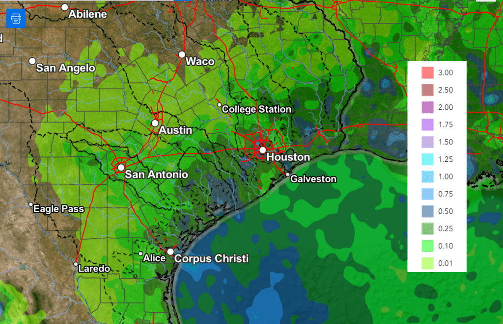
Rain amounts through Saturday evening are not predicted to be all that heavy, with the highest totals expected to occur across the coastal plains. Totals are forecast to generally be around a quarter inch or less across the Hill Country and Central Texas regions, and around a half inch towards the coast. Because of the tropical nature of this system, a couple of isolated heavy downpours, with totals of 1-2 inches cannot be ruled out.
NWS Rainfall Forecast Valid through 7 am Sunday:
High temperatures are forecast to be in the upper 90s Friday, and in the mid-90s Saturday.
Mostly sunny, dry, and hot weather is forecast across the region Sunday and Monday. High temperatures both days are predicted to be near 98-100 degrees.
Tuesday through late next week, forecasts call for the ridge of high pressure to become centered over the Four Corners region while a weak trough develops over the eastern U.S. The combination of some weak disturbances rotating south around the eastern periphery of the ridge and abundant moisture spreading north from the Gulf will cause a 20-30 percent chance for scattered rain showers and thunderstorms each day across the region. Spotty totals to around a quarter inch are forecast. Expect high temperatures to be mostly in the upper 90s.
Looking out further into next weekend and the following week, little change in the pattern is expected. High temperatures look to stay in the mid and upper 90s.
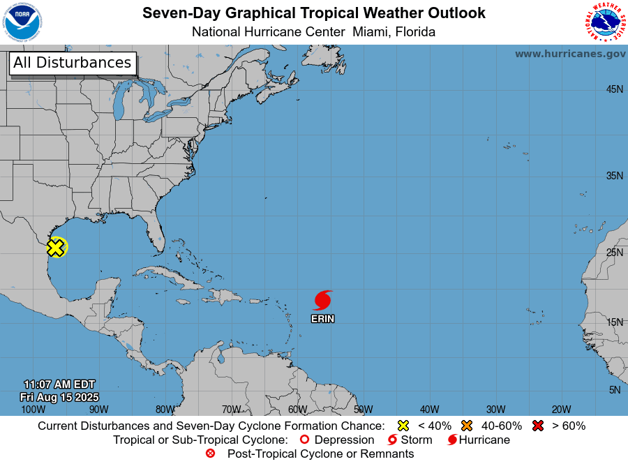
Tropical Weather Outlook
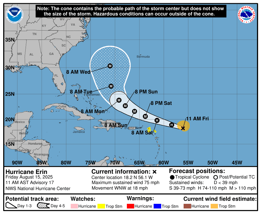
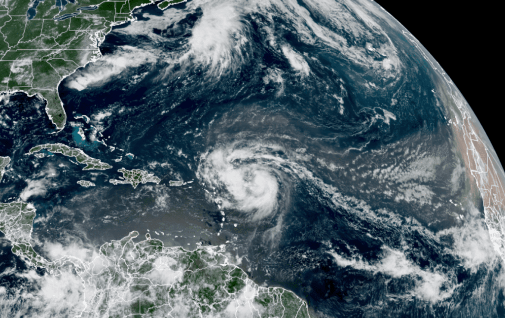
Erin has become the first hurricane of the 2025 season and is expected to pass north of the Leeward Island Saturday.
As of 9 am CDT. the center of Hurricane Erin was located over the central tropical Atlantic, about 460 miles east of the northern Leeward Islands. Erin was moving toward the west-northwest near 18 mph. This motion is expected to continue into the weekend. On the forecast track, the center of Erin is likely to move near or just north of the northern Leeward Islands over the weekend.
Reports from NOAA and Air Force Reserve Hurricane Hunter aircraft indicate that maximum sustained winds have increased to near 75 mph with higher gusts. Steady to rapid strengthening is expected during the next two to three days, and Erin is forecast to become a major hurricane during the weekend. Forecasts keep Erin the east of the U.S. east coast next week.
NOAA/Colorado State University 08-15-25 10:50 am CDT
Elsewhere, there are no systems in place which pose a threat for tropical development over the next several days.
Have a great weekend!
Bob
This page was created on Friday, 08/15. For the most update to date weather information, please consult the National Weather Service and the National Hurricane Center:
Social Media