Waves of Rain and Thunderstorms Forecast through Friday. Significant Rain Possible
June 9, 2025
An active weather pattern will be in place this week as a series of low pressure troughs dive southeast out of the southern Rockies, causing the development of waves of rain showers and thunderstorms through Friday. Each wave of rain is expected to bring a chance for strong to severe storms along with locally heavy rain. The risk for flooding will increase throughout the week as each wave is expected to bring significant rain.
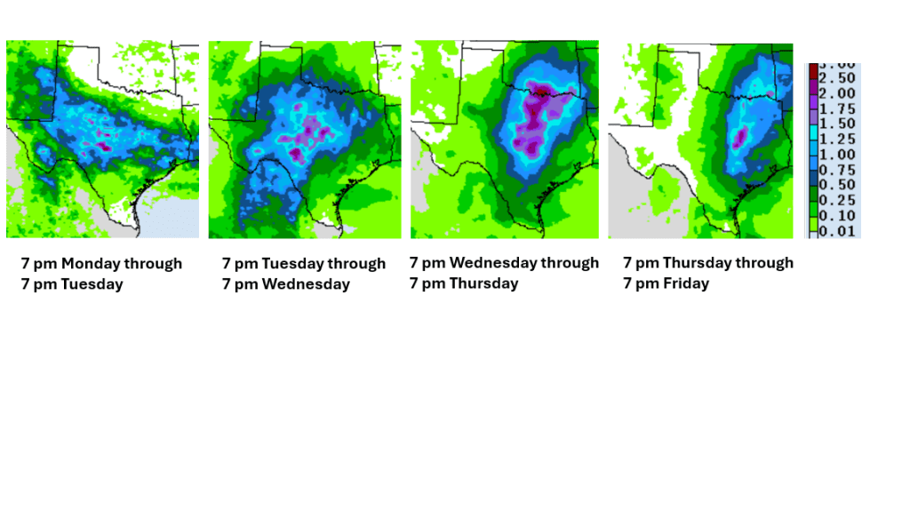
An area of rain and thunderstorms spread southeast across the northern Hill Country and the eastern counites of Central Texas early Monday morning. Rain amounts generally averaged around a half inch. The area of storms dissipated after sunrise. In their wake, the atmosphere over the region has temporarily become a bit more stable. Weather conditions Monday afternoon are forecast to be mostly sunny and warm. There will be a 20 percent chance for a couple of isolated showers and thunderstorms, but nothing widespread is anticipated. Monday’s temperature is forecast to peak in the low and mid-90s.
Attention will turn northwest to eastern New Mexico Monday evening where a large area of rain showers and thunderstorms is forecast to develop ahead of an approaching trough of low pressure. High resolutions forecasts call for this area of rain and storms to track to the southeast, moving into West Texas Monday evening. The area of rain and storms is forecast to reach the northwestern Hill Country after midnight and spreading across the remainder of the Hill Country late Monday through daybreak Tuesday. The rain and storms are forecast to spread southeast to the Austin/Interstate 35 corridor Tuesday morning, then further southeast Tuesday afternoon. Some of the storms Monday night into Tuesday could be strong to severe. The probability for rain will be near 50-60 percent. The Storm Prediction Center has placed the entire region under a 1 out of 5 risk for severe thunderstorms through 7 am Wednesday. The primary severe weather threats will be damaging winds, large hail, and locally heavy rain. Behind the line of storms, there will be a chance for scattered thunderstorms across the area Tuesday afternoon. Rain amounts from this next wave of rain are forecast to be heaviest across the northern Hill Country, where totals to near 1 inch are forecast. Elsewhere, totals are forecast to generally average around a half inch.
Forecasts call for another are of rain and storms to develop across West and Southwest Texas Tuesday evening, with this area of rain and storms spreading east across the Hill Country and Central Texas regions Wednesday morning. Additional periods of rain and storms are predicted across the region Wednesday through Friday as more troughs of low pressure track southeast out of the southern Rockies. Storm coverage Wednesday through Friday will be highly dependent
on what happens on the preceding day. However, with a frontal boundary forecast to stall over Central Texas, the focus for thunderstorms will definitely be there. The probability for rain Wednesday through Friday will be near 60-70 percent each day. There will be a chance for some of the thunderstorms each day to be strong to severe. In addition, the rain has the potential to become heavier late Wednesday into Friday.
National Weather Service Forecast Rain Amounts by Day:
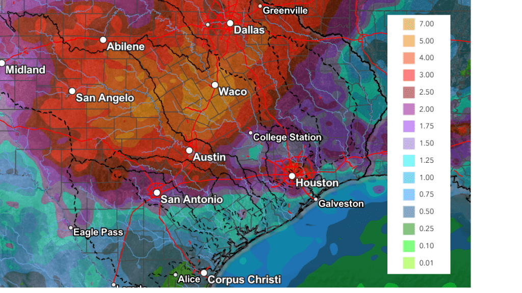
Cumulative rain amounts through 7 pm Saturday are forecast to generally average between 3 and 5 inches across the northern Hill Country, between 2 and 4 inches across the remainder of the Hill Country and most of Central Texas, and between 1 and 2 inches for areas south of Interstate 10.
NWS Rainfall Forecast for the period 7 pm Monday through 7 pm Saturday:
The chance for rain will decrease this weekend when a ridge of high pressure begins to slowly push north across Texas out of Mexico. However, lingering moisture and instability may cause a few scattered afternoon showers and thunderstorms across the area. The probability for rain will be around 30 percent across the Hill Country and Central Texas regions, and near 50 percent across the coastal plains. Rain amounts both days are forecast to average less than a quarter inch.
Looking out into next week, forecasts call for mostly sunny conditions with just a few isolated showers possible the first half of the week. High temperatures are predicted to generally be in the mid-90s.
Tropical Weather Outlook
Weather conditions remain quiet across the tropical Atlantic and tropical cyclone development is not forecast over the next seven days.
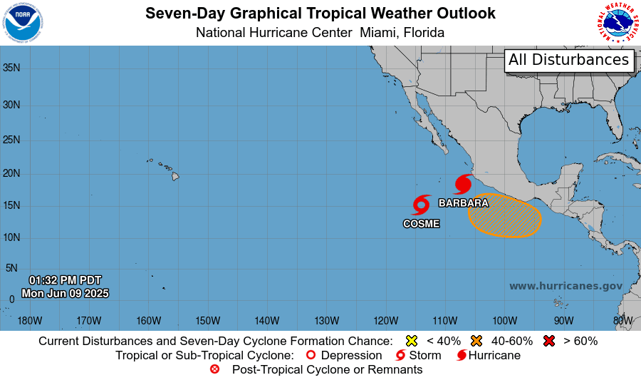
In the eastern tropical Pacific, Hurricane Barbara has developed a couple of hundred miles off the southwest coast of Mexico. Barbara is the first hurricane-strength tropical cyclone of the 2025 Northern Hemisphere season. Barbara is the latest 1st Northern Hemisphere hurricane since 1993.
In addition to Barbara, Tropical Storm Cosme has developed around 620 miles south-southwest of the southern tip of Baja, California. Cosme is forecast to become a hurricane by Monday evening.
The June Full Moon
The June Full Moon, also known as the Strawberry Moon, will be visible Tuesday night and Wednesday night. It will be the lowest-hanging full moon since 2006, making it appear larger and more reddish-orange when it rises on Tuesday, June 10th, in the southeastern sky. This year’s Strawberry Moon is also being referred to as a “micro moon” because it will be at its farthest point from Earth.
Bob
Social Media