Weather Pattern Trending Drier and Warmer
June 13, 2025
Weather conditions across the Hill Country and Central Texas are expected to trend drier and a bit warmer this afternoon and through the weekend as this week’s persistent trough of low pressure lifts off to the northeast. At the same time, a ridge of high pressure currently centered over northwestern Mexico is forecast to expand east into the western half of Texas. This will cause the atmosphere across West Texas, the Edwards Plateau, and the Hill Country to become drier and more stable.
Friday afternoon through Sunday
For the Hill Country, a mostly sunny to partly cloudy sky and dry weather is forecast. Expect daily high temperatures to be near 90-92 degrees.
Across Central Texas, there will be just a 20 percent chance for a few isolated to scattered afternoon and evening rain showers and thunderstorms each day. Rain amounts through Sunday are forecast to total less than a half inch. Daily high temperatures are predicted to generally be in the low 90s.
Across the coastal plains, forecasts call for a 40-50 percent chance for mainly afternoon and evening showers and thunderstorms each day as several weak disturbances cause a continued unsettled weather pattern. Rain amounts through Sunday are forecast to generally average between 1 and 2 inches. Some locally heavy downpours will be possible. Daily high temperatures are forecast to be around 90 degrees.
NWS Rainfall Forecast Valid through 7 pm Monday:
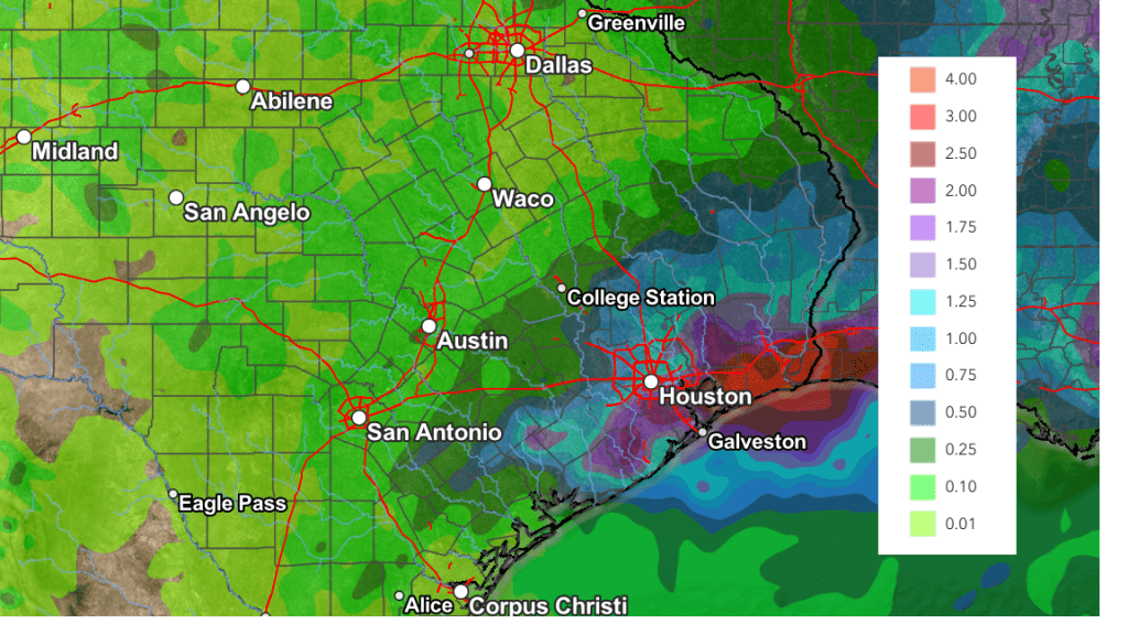
For next Monday through Wednesday, little overall change in the weather pattern is expected. The ridge of high pressure over Mexico is forecast to expand a little further to the east and this is expected to diminish the chance for rain across Central Texas. Meanwhile across the coastal plains region, there will be a 20-30 percent chance for scattered afternoon showers and thunderstorms due to abundant moisture and the sea breeze front. Rain amounts through Wednesday are forecast to only average around a quarter inch.
- High temperatures Monday through Wednesday are forecast to be in the mid-90s across the Hill Country and Central Texas regions, and in the low 90s across the coastal plains
Late Next Week into Next Weekend
A daily chance for scattered rain showers and thunderstorms will return to the forecast across the region as the ridge of high pressure retreats to the west and a weak trough of low pressure tracks across the southern Plains states. The probability for rain will range from around 20 percent across the Hill Country, to near 50 percent across the coastal plains. As of now, heavy rain is not expected through this upcoming period, with most totals averaging around a half inch. Expect a partly to mostly cloudy. Daily high temperatures are forecast to generally be in the low and mid-90s.
Looking out in the week of June 23rd, forecasts call for generally dry and warm conditions as the ridge of high pressure returns to the area. Daily high temperatures are predicated to be in the mid-90s.
Tropical Weather Outlook
Weather conditions remain quiet across the tropical Atlantic and tropical cyclone development is not expected during the next seven days.
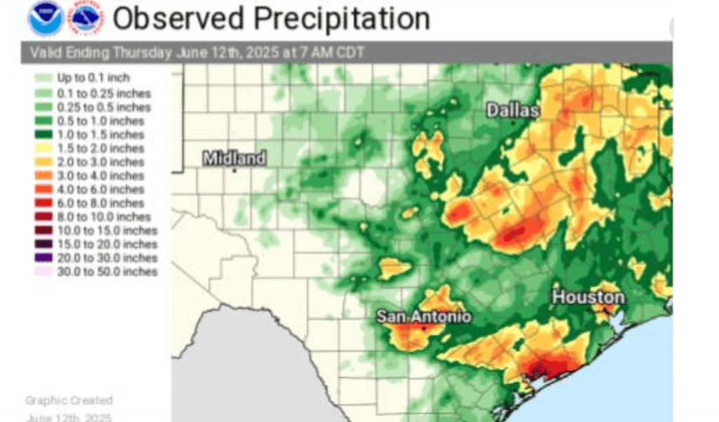
Rainfall Wednesday Night into Thursday Morning
There were numerous storms with heavy rain across Texas Wednesday night, but most of the heavy rains stayed to the north and south of the Hill Country and Central Texas. Totals of 5-7.5 inches were recorded across the area between New Braunfels and San Antonio and also across most of Matagorda County, resulting in quite a bit of flooding. Nearly a foot of rain was recorded by an observer west of Palacios. Another observer located in northern Calhoun County, near Port Alto recorded over 14 inches!
Have a great weekend!
Bob
Social Media