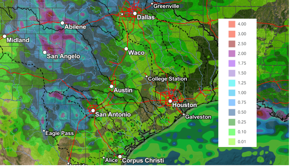
Forecast for Central Texas

 20%20%20%
 0%0%
0%0%
Reports from LCRA’s Hydromet
Rainfall summaryTemperature summary
Humidity summary
Bob's Blog on Central Texas Weather
Weather Pattern Trending Drier and Warmer
Weather conditions across the Hill Country and Central Texas are expected to trend drier and a bit warmer this afternoon and through the weekend as this week’s persistent trough of low pressure lifts off to the northeast. At the same time, a ridge of high pressure currently centered over northwestern Mexico is forecast to expand east into the western half of Texas. This will cause the atmosphere across West Texas, the Edwards Plateau, and the Hill Country to become drier and more stable.
Friday afternoon through Sunday
For the Hill Country, a mostly sunny to partly cloudy sky and dry weather is forecast. Expect daily high temperatures to be near 90-92 degrees.
Across Central Texas, there will be just a 20 percent chance for a few isolated to scattered afternoon and evening rain showers and thunderstorms each day. Rain amounts through Sunday are forecast to total less than a half inch. Daily high temperatures are predicted to generally be in the low 90s.
Across the coastal plains, forecasts call for a 40-50 percent chance for mainly afternoon and evening showers and thunderstorms each day as several weak disturbances cause a continued unsettled weather pattern. Rain amounts through Sunday are forecast to generally average between 1 and 2 inches. Some locally heavy downpours will be possible. Daily high temperatures are forecast to be around 90 degrees.
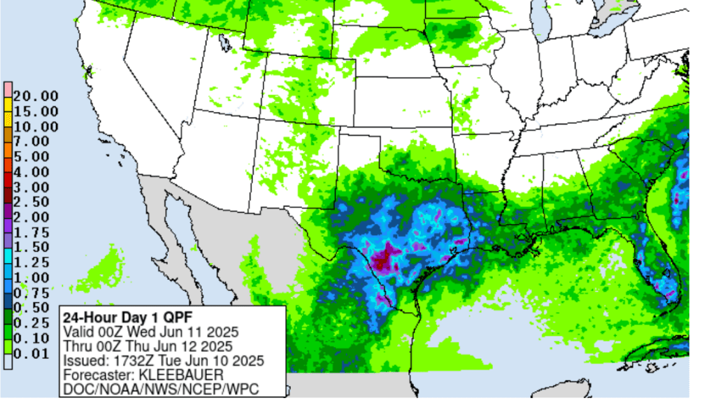
NWS Rainfall Forecast Valid through 7 pm Monday:
For next Monday through Wednesday, little overall change in the weather pattern is expected. The ridge of high pressure over Mexico is forecast to expand a little further to the east and this is expected to diminish the chance for rain across Central Texas. Meanwhile across the coastal plains region, there will be a 20-30 percent chance for scattered afternoon showers and thunderstorms due to abundant moisture and the sea breeze front. Rain amounts through Wednesday are forecast to only average around a quarter inch.
- High temperatures Monday through Wednesday are forecast to be in the mid-90s across the Hill Country and Central Texas regions, and in the low 90s across the coastal plains
Late Next Week into Next Weekend
A daily chance for scattered rain showers and thunderstorms will return to the forecast across the region as the ridge of high pressure retreats to the west and a weak trough of low pressure tracks across the southern Plains states. The probability for rain will range from around 20 percent across the Hill Country, to near 50 percent across the coastal plains. As of now, heavy rain is not expected through this upcoming period, with most totals averaging around a half inch. Expect a partly to mostly cloudy. Daily high temperatures are forecast to generally be in the low and mid-90s.
Looking out in the week of June 23rd, forecasts call for generally dry and warm conditions as the ridge of high pressure returns to the area. Daily high temperatures are predicated to be in the mid-90s.
Tropical Weather Outlook
Weather conditions remain quiet across the tropical Atlantic and tropical cyclone development is not expected during the next seven days.
Rainfall Wednesday Night into Thursday Morning
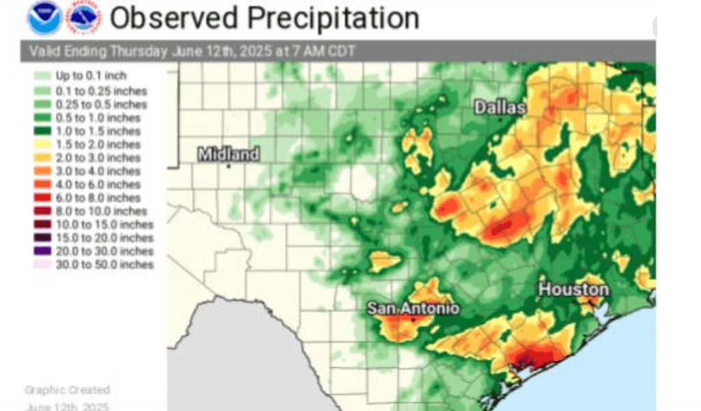
There were numerous storms with heavy rain across Texas Wednesday night, but most of the heavy rains stayed to the north and south of the Hill Country and Central Texas. Totals of 5-7.5 inches were recorded across the area between New Braunfels and San Antonio and also across most of Matagorda County, resulting in quite a bit of flooding. Nearly a foot of rain was recorded by an observer west of Palacios. Another observer located in northern Calhoun County, near Port Alto recorded over 14 inches!
Have a great weekend!
Bob
Significant Rain Possible Wednesday Night into Thursday
The wet and unsettled weather pattern looks to continue Wednesday night through Thursday afternoon.
The large complex of rain and storms which spread across the Hill Country and Central Texas Tuesday night brought showers and thunderstorms to Southeast Texas and the middle Texas coast Wednesday morning into Wednesday afternoon. As of 4 pm, most of the rain had exited east into Louisiana.
A large trough of low pressure in the middle and upper atmosphere remains in place over Central and North Texas. Although the atmosphere has temporarily stabilized in the wake of the departing complex of storms, additional showers and thunderstorms are forecast to develop and spread across region Wednesday night into Thursday as yet another wave of low pressure circulates southeast into the Hill Country and Central Texas.
High resolution forecasts call for showers and thunderstorms to develop across the Hill Country and the Austin/Interstate 35 corridor this evening ahead of that approaching wave. This will be different from the past couple of nights when the thunderstorms moved into our region from Mexico and Far West Texas. The shower and thunderstorms are forecast to increase in areal coverage throughout the evening hours. Thursday night’s rains are expected to be slow movers, and with the atmosphere still quite moist, locally heavy rain may become a big concern Wednesday evening through Thursday morning.
The National Weather Service predicts the highest totals of rain will occur near and east of the I-35 corridor, for areas generally along and north of a Burnet, to Austin, to La Grange line. Since this area has seen recent rain and soils are wet, the NWS has posted a Flood Watch for Burnet, Williamson, Travis (including the Austin metro area), Lee, Bastrop and Fayette counties. The watch will begin at 7 PM Wednesday evening and will run through 7 pm Thursday. Rain amounts of 2-4 inches will be possible in the watch area, with amounts up to 5-6 inches possible in a few spots.

Forecasts call for the heaviest rains to shift east of the Hill Country and Interstate 35 shortly after daybreak Thursday, spreading southeast to the middle Texas coast Thursday morning. Periods of heavy rain will be possible as the large area of rain slowly moves to the southeast. A slight chance for showers and thunderstorms is forecast Thursday afternoon across the Hill Country and Central Texas following the large area of rain and storms.
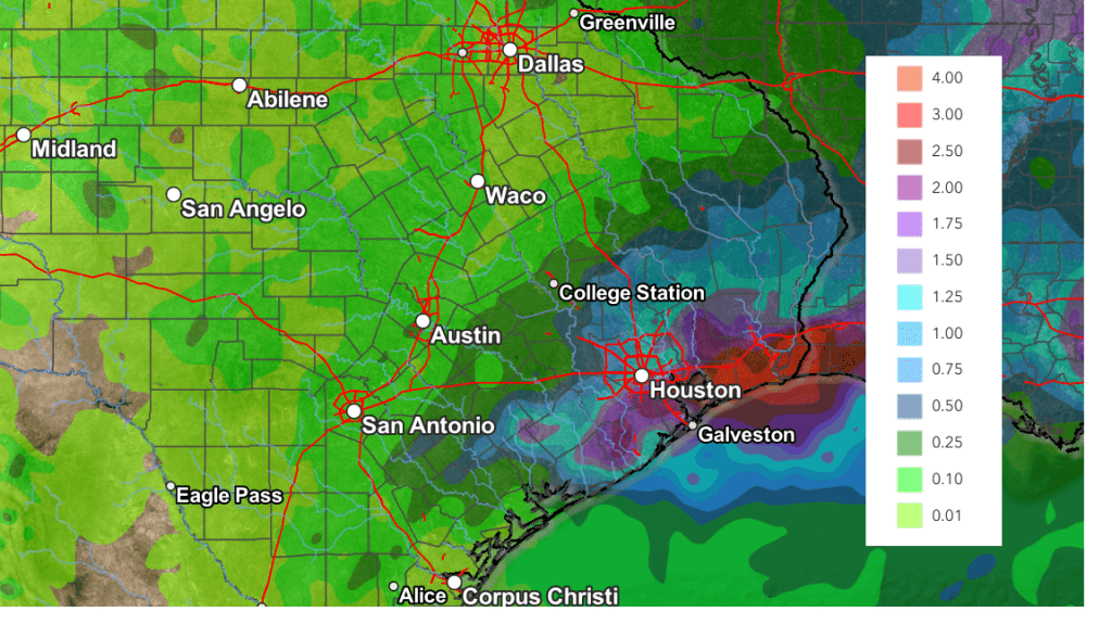
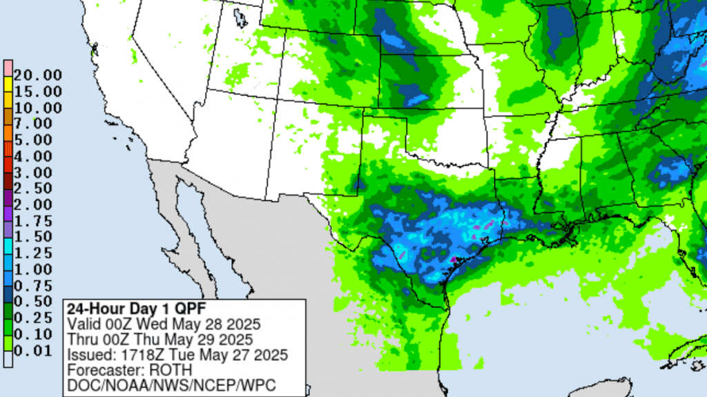
Rainfall forecasts through Thursday afternoon call for widespread totals of 1-3 inches across the region, with isolated totals of 5-6 inches possible over the area between Burnet and La Grange.
NWS Rainfall Forecast Valid through 7 pm Thursday:
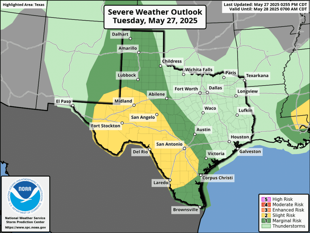
Some of the developing thunderstorms Wednesday night into Thursday morning may be strong to severe. The Storm Prediction Center has place the area roughly between San Antonio and Houston in a 2 out of 5 severe thunderstorm risk. The rest of the area, including Austin and Travis County, is under a 1 out of 5 severe thunderstorm risk. The primary severe weather threats will be large hail and damaging winds.

The threat for heavy rain is predicted to diminish late Thursday as that last wave of low pressure lifts off to the northeast. Forecasts do call for a 20-30 percent chance for scattered showers and thunderstorms across the area Friday through Sunday. However, rain amounts are predicted on only be around a quarter inch.
Bob
Another Complex of Thunderstorms Expected Tuesday Night
Confidence is increasing for another complex of thunderstorms to move across the Hill Country and Central Texas regions late Tuesday night.
Tuesday’s analysis showed a trough of low pressure tracking east across northeastern Mexico and southern New Mexico. This feature is expected to cause the development of a large area of thunderstorms across Far West Texas and the Rio Grande Plains late this afternoon. With a moist and fairly unstable air mass in place, these thunderstorms are forecast to quickly become strong to severe, potentially causing damaging winds and large hail.
High resolution forecasts call for the area of thunderstorms to slowly move to the east, reaching the area between Ballinger, Junction, and Uvalde by about 11 pm. The area of storms is predicted to push east across the Hill Country between 11 pm and about 4 am, reaching the Austin/Interstate 35 corridor between roughly 4 am and 7 am Wednesday. The storms are forecast to push east of Interstate 35 after 7 am and weaken.
Do note some isolated thunderstorms could develop across parts of the Hill Country and the I-35 corridor after midnight, ahead of the main line of storms.
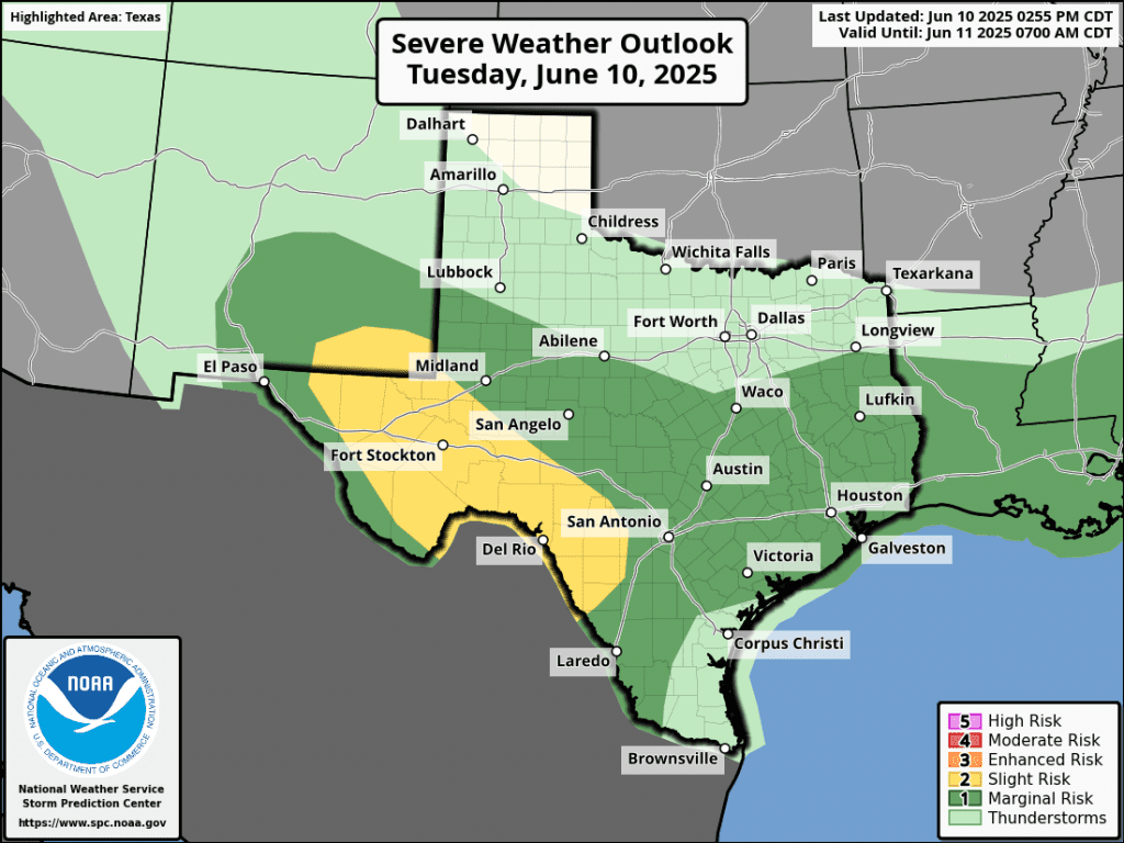
Some of the overnight storms could be strong to severe. The primary severe weather risks will be damaging winds and large hail. The Storm Prediction Center has placed the Hill Country, all of Central Texas, and the middle Texas coast under a 1 out of 5 risk for severe storms through Wednesday.
Rainfall from this complex of rain and thunderstorms is forecast to generally average around 1 inch, with isolated totals of 2-3 inches possible.
NWS Rainfall Forecast Valid through 7 pm Wednesday:
While this particular complex of storms is forecast to weaken after sunrise Wednesday, showers and thunderstorms are forecast to develop and increase in areal coverage across much of Central Texas and the middle Texas coast Wednesday afternoon and evening.
Forecasts call for additional waves of showers and thunderstorms to spread across the region Thursday through Saturday. The probability for rain will be near 70 percent Thursday, but decrease to around 40 percent for Friday and Saturday. This will be followed by just a slight chance for scattered showers Sunday and Monday.
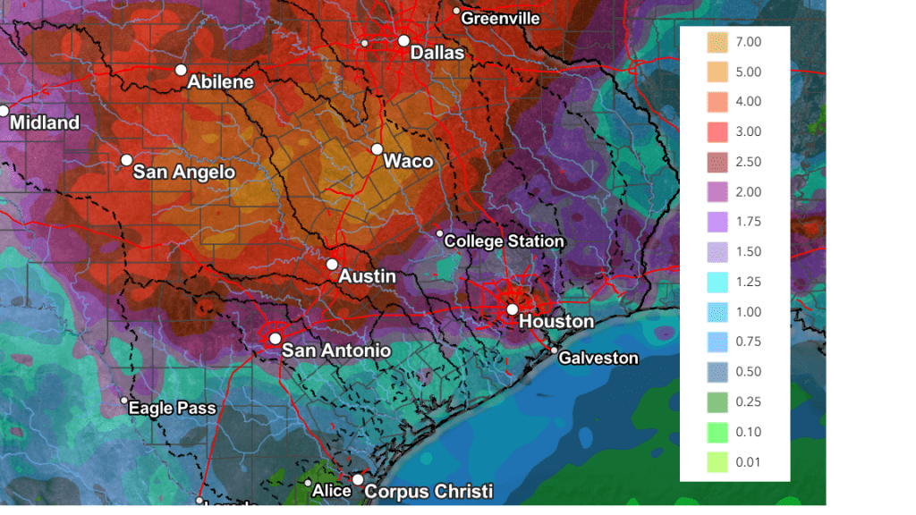
The National Weather Service’s cumulative rainfall forecast through Sunday evening calls for totals of 2-3 inches across the Hill Country and Central Texas, and around 2-2.5 inches across the middle Texas coast.
NWS Rainfall Forecast Valid through 7 pm Sunday:
Forecasts continue to point toward generally dry and warmer weather next week.
Bob
Waves of Rain and Thunderstorms Forecast through Friday. Significant Rain Possible
An active weather pattern will be in place this week as a series of low pressure troughs dive southeast out of the southern Rockies, causing the development of waves of rain showers and thunderstorms through Friday. Each wave of rain is expected to bring a chance for strong to severe storms along with locally heavy rain. The risk for flooding will increase throughout the week as each wave is expected to bring significant rain.
An area of rain and thunderstorms spread southeast across the northern Hill Country and the eastern counites of Central Texas early Monday morning. Rain amounts generally averaged around a half inch. The area of storms dissipated after sunrise. In their wake, the atmosphere over the region has temporarily become a bit more stable. Weather conditions Monday afternoon are forecast to be mostly sunny and warm. There will be a 20 percent chance for a couple of isolated showers and thunderstorms, but nothing widespread is anticipated. Monday’s temperature is forecast to peak in the low and mid-90s.
Attention will turn northwest to eastern New Mexico Monday evening where a large area of rain showers and thunderstorms is forecast to develop ahead of an approaching trough of low pressure. High resolutions forecasts call for this area of rain and storms to track to the southeast, moving into West Texas Monday evening. The area of rain and storms is forecast to reach the northwestern Hill Country after midnight and spreading across the remainder of the Hill Country late Monday through daybreak Tuesday. The rain and storms are forecast to spread southeast to the Austin/Interstate 35 corridor Tuesday morning, then further southeast Tuesday afternoon. Some of the storms Monday night into Tuesday could be strong to severe. The probability for rain will be near 50-60 percent. The Storm Prediction Center has placed the entire region under a 1 out of 5 risk for severe thunderstorms through 7 am Wednesday. The primary severe weather threats will be damaging winds, large hail, and locally heavy rain. Behind the line of storms, there will be a chance for scattered thunderstorms across the area Tuesday afternoon. Rain amounts from this next wave of rain are forecast to be heaviest across the northern Hill Country, where totals to near 1 inch are forecast. Elsewhere, totals are forecast to generally average around a half inch.
Forecasts call for another are of rain and storms to develop across West and Southwest Texas Tuesday evening, with this area of rain and storms spreading east across the Hill Country and Central Texas regions Wednesday morning. Additional periods of rain and storms are predicted across the region Wednesday through Friday as more troughs of low pressure track southeast out of the southern Rockies. Storm coverage Wednesday through Friday will be highly dependent
on what happens on the preceding day. However, with a frontal boundary forecast to stall over Central Texas, the focus for thunderstorms will definitely be there. The probability for rain Wednesday through Friday will be near 60-70 percent each day. There will be a chance for some of the thunderstorms each day to be strong to severe. In addition, the rain has the potential to become heavier late Wednesday into Friday.
National Weather Service Forecast Rain Amounts by Day:
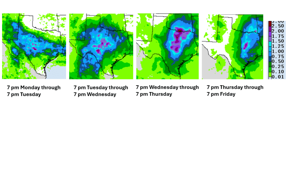
Cumulative rain amounts through 7 pm Saturday are forecast to generally average between 3 and 5 inches across the northern Hill Country, between 2 and 4 inches across the remainder of the Hill Country and most of Central Texas, and between 1 and 2 inches for areas south of Interstate 10.
NWS Rainfall Forecast for the period 7 pm Monday through 7 pm Saturday:
The chance for rain will decrease this weekend when a ridge of high pressure begins to slowly push north across Texas out of Mexico. However, lingering moisture and instability may cause a few scattered afternoon showers and thunderstorms across the area. The probability for rain will be around 30 percent across the Hill Country and Central Texas regions, and near 50 percent across the coastal plains. Rain amounts both days are forecast to average less than a quarter inch.
Looking out into next week, forecasts call for mostly sunny conditions with just a few isolated showers possible the first half of the week. High temperatures are predicted to generally be in the mid-90s.
Tropical Weather Outlook
Weather conditions remain quiet across the tropical Atlantic and tropical cyclone development is not forecast over the next seven days.
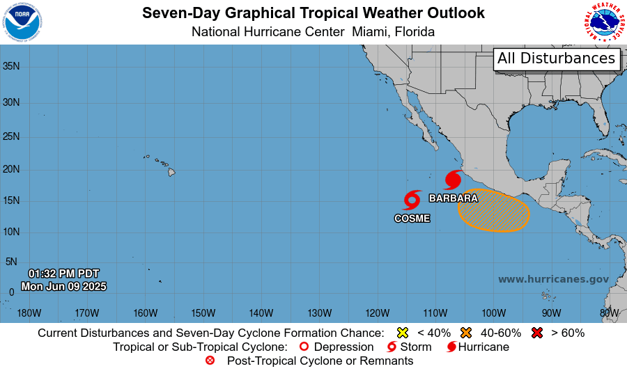
In the eastern tropical Pacific, Hurricane Barbara has developed a couple of hundred miles off the southwest coast of Mexico. Barbara is the first hurricane-strength tropical cyclone of the 2025 Northern Hemisphere season. Barbara is the latest 1st Northern Hemisphere hurricane since 1993.
In addition to Barbara, Tropical Storm Cosme has developed around 620 miles south-southwest of the southern tip of Baja, California. Cosme is forecast to become a hurricane by Monday evening.
The June Full Moon
The June Full Moon, also known as the Strawberry Moon, will be visible Tuesday night and Wednesday night. It will be the lowest-hanging full moon since 2006, making it appear larger and more reddish-orange when it rises on Tuesday, June 10th, in the southeastern sky. This year’s Strawberry Moon is also being referred to as a “micro moon” because it will be at its farthest point from Earth.
Bob
Forecasts Point to an Increasing Chance for Significant Rain Next Week
The broad dome of high pressure that is expected to bring very hot temperatures to the region this weekend is forecast to weaken and back southwest into Mexico early next week. As the high shifts southwest, it is expected to cause winds in the middle and upper atmosphere to flow from the southern Rockies into Texas for most of next week. This type of pattern in early June often results in a very active weather pattern for much of Texas. In this pattern, waves of low pressure often move in from the northwest, causing the development of widespread rain showers and thunderstorms. Forecasts call for a weak cold front to sink south into Central Texas the middle of next week and this feature may help to enhance the chance for rain and thunderstorms.
The outlook for next week shows a high chance for rain next Tuesday through Thursday, with the chance for rain decreasing late week into next weekend.
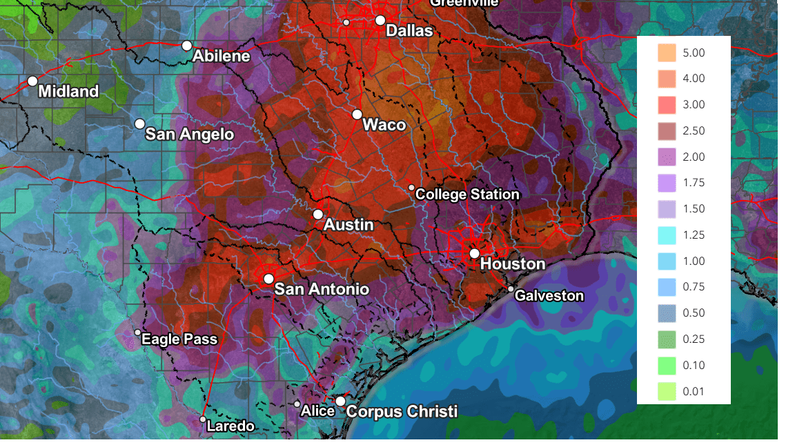
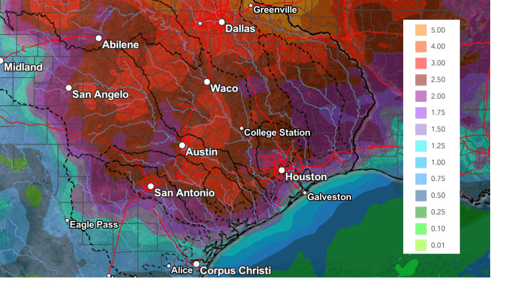
The National Weather Service’s rainfall forecast through 7 pm next Friday calls for widespread totals of 2-4 inches, with some pockets of 3-5 inch totals possible.
NWS Rainfall Forecast Valid through 7 pm Next Friday:
Stay tuned for additional updates as the forecasts get a better handle of this changing weather pattern.
Have a great weekend!
Bob
Significant Rain Possible Wednesday Night into Thursday
The wet and unsettled weather pattern looks to continue Wednesday night through Thursday afternoon.
The large complex of rain and storms which spread across the Hill Country and Central Texas Tuesday night brought showers and thunderstorms to Southeast Texas and the middle Texas coast Wednesday morning into Wednesday afternoon. As of 4 pm, most of the rain had exited east into Louisiana.
A large trough of low pressure in the middle and upper atmosphere remains in place over Central and North Texas. Although the atmosphere has temporarily stabilized in the wake of the departing complex of storms, additional showers and thunderstorms are forecast to develop and spread across region Wednesday night into Thursday as yet another wave of low pressure circulates southeast into the Hill Country and Central Texas.
High resolution forecasts call for showers and thunderstorms to develop across the Hill Country and the Austin/Interstate 35 corridor this evening ahead of that approaching wave. This will be different from the past couple of nights when the thunderstorms moved into our region from Mexico and Far West Texas. The shower and thunderstorms are forecast to increase in areal coverage throughout the evening hours. Thursday night’s rains are expected to be slow movers, and with the atmosphere still quite moist, locally heavy rain may become a big concern Wednesday evening through Thursday morning.
The National Weather Service predicts the highest totals of rain will occur near and east of the I-35 corridor, for areas generally along and north of a Burnet, to Austin, to La Grange line. Since this area has seen recent rain and soils are wet, the NWS has posted a Flood Watch for Burnet, Williamson, Travis (including the Austin metro area), Lee, Bastrop and Fayette counties. The watch will begin at 7 PM Wednesday evening and will run through 7 pm Thursday. Rain amounts of 2-4 inches will be possible in the watch area, with amounts up to 5-6 inches possible in a few spots.
Forecasts call for the heaviest rains to shift east of the Hill Country and Interstate 35 shortly after daybreak Thursday, spreading southeast to the middle Texas coast Thursday morning. Periods of heavy rain will be possible as the large area of rain slowly moves to the southeast. A slight chance for showers and thunderstorms is forecast Thursday afternoon across the Hill Country and Central Texas following the large area of rain and storms.
Rainfall forecasts through Thursday afternoon call for widespread totals of 1-3 inches across the region, with isolated totals of 5-6 inches possible over the area between Burnet and La Grange.
NWS Rainfall Forecast Valid through 7 pm Thursday:
Some of the developing thunderstorms Wednesday night into Thursday morning may be strong to severe. The Storm Prediction Center has place the area roughly between San Antonio and Houston in a 2 out of 5 severe thunderstorm risk. The rest of the area, including Austin and Travis County, is under a 1 out of 5 severe thunderstorm risk. The primary severe weather threats will be large hail and damaging winds.
The threat for heavy rain is predicted to diminish late Thursday as that last wave of low pressure lifts off to the northeast. Forecasts do call for a 20-30 percent chance for scattered showers and thunderstorms across the area Friday through Sunday. However, rain amounts are predicted on only be around a quarter inch.
Bob
A Chance for Thunderstorms Tuesday and Tuesday Night. Hot Weather Going into the Weekend
We’re looking at a warmer and less active weather pattern this week as our region begins to feel the influence from a heat dome over northwestern Mexico. Much of the area will see a chance for thunderstorms Tuesday night into Wednesday morning. Otherwise, the pattern is looking to stay dry through the upcoming weekend and into early next week.
Monday’s weather is expected to be mostly sunny and hot as a ridge of high pressure spreads over Texas out of Mexico. High temperatures are forecast to be in the mid-90s. Lows Tuesday morning are predicted to be mostly in the mid-70s.
A change in the weather pattern is forecast to take place Tuesday into Wednesday when the ridge of high pressure over Texas weakens, allowing a trough of low pressure to lift northeast from New Mexico into the southern Plains states. Scattered thunderstorms are forecast to develop across West and Far West Texas Monday evening in response to the approaching trough. Some of these thunderstorms are predicted to spread as far east as the western and northern Hill Country late Monday night and toward daybreak Tuesday. The threat for any of these storms to be severe will be quite low. This particular area of storms is forecast to diminish around daybreak Tuesday.
A second and somewhat better chance for showers and thunderstorms is forecast to take place across the western and northern Hill Country Tuesday afternoon as another area of thunderstorms blossoms across West Texas in response to the approaching trough over New Mexico. These storms are predicted to spread east across the Hill Country and into Central Texas Tuesday afternoon into Tuesday night, reaching the coastal plains region Wednesday morning. The probability for rain Tuesday afternoon through Wednesday morning will be at 40-50 percent.
Some of the storms Tuesday afternoon and evening may be strong to severe across the Hill Country. The Storm Prediction Center has placed most of North Texas, extending south to Burnet, Mason, and Eldorado under a Slight Risk, or a 2 out of 5 risk for severe storms through 7 am Wednesday. A Marginal Risk, or a 1 out of 5 risk, for severe storms extends as far south as Austin, Kerrville, and Rocksprings.

The primary severe weather threats will be large hail and damaging winds, with a tertiary tornado threat. The rain and thunderstorms are predicted to evolve into clusters of storms that will spread to the south along a weak cold front. The front is forecast to reach the coastal plains region Wednesday morning. The chance for rain and storms should end from northwest to southeast as drier and slightly cooler air spreads in behind the cold front.
Rain amounts through Wednesday are forecast to be highest across the northern Hill Country, and lowest towards the coast. Totals will range from 0.5 to 1 inch across the north, to less than a quarter inch for locations south of Interstate 10.
NWS Rainfall Forecast Valid through 7 pm Wednesday:
The temperature is forecast to trend a bit lower Wednesday in the wake of the cold front. Afternoon high temperatures will range from the mid-80s across the northern Hill Country, to the low 90s across the coastal plains. The cold front’s visit will be brief as it is predicted to lift back to the north late Wednesday night.
Mostly sunny, dry, and hot weather is forecast Thursday and through the weekend as a ridge of high pressure centered over Mexico spreads east to cover Texas.
- High temperatures Thursday are forecast to be in the low and mid-90s
- High temperatures Friday are predicted to be in the mid and upper 90s
- High temperatures Saturday through Monday are forecast to be near 100 degrees across the Hill Country and Central Texas regions, and in the mid-90s across the coastal plains
Looking ahead to next week, the forecast solutions call for the ridge of high pressure to shift slightly to the west, which should help cause high temperatures to lower slightly to the mid and upper 90s. There are indications we could see a chance for rain develop around the middle of next week.
Tropical Weather Outlook
National Hurricane Center forecasters are monitoring the area offshore of the southeastern U.S. Coast where a non-tropical area of low pressure is forecast to form near or just offshore of the coast during the next couple of days. If the system remains offshore, the low could gradually develop some subtropical or tropical characteristics later this week while moving northeastward at 10 to 15 mph.
NHC is giving this system a low chance, just a 10 percent chance for tropical development over the next seven days.
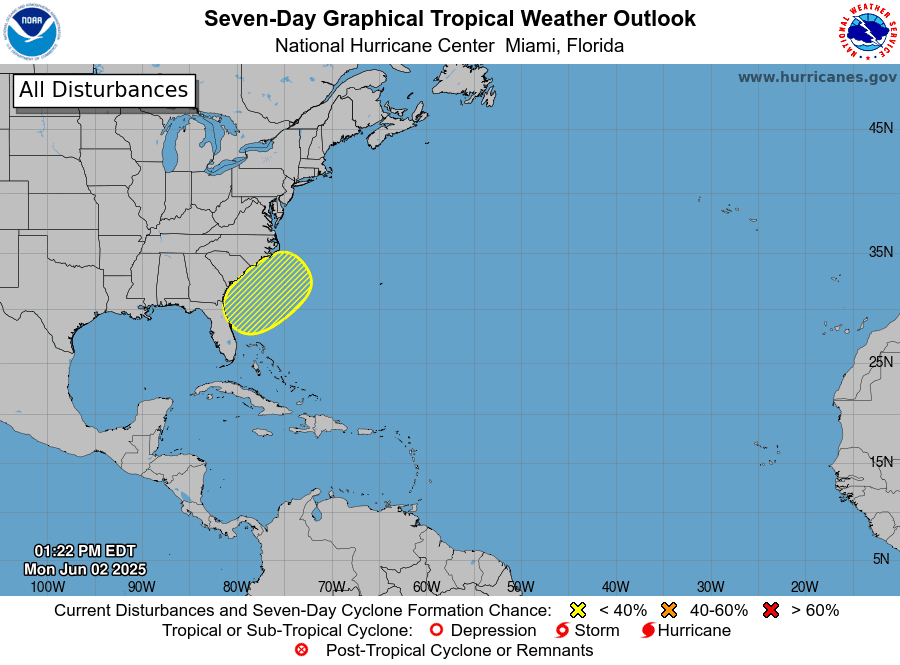
Elsewhere, weather conditions are quiet and tropical cyclone development is not expected over the next seven days.
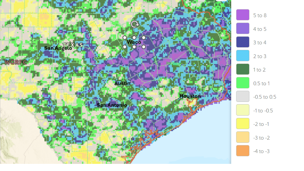
May Rainfall Was Above Normal Across Most of Region
The month of May concluded with rain totals above normal at most locations. Some of the highest totals for the month occurred around Lake Buchanan, where an LCRA gauge on the northeast side of the lake recorded 10.5 inches. A gauge located in western Fayette County recorded a monthly total of 9.34 inches. The area receiving the least amount of rain was across the western Hill Country between Eldorado and Sonora, extending east to near Harper, where monthly totals only averaged between 1 and 2 inches.
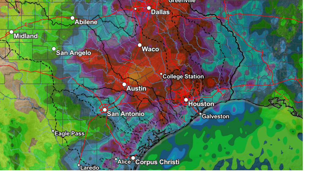
May Rainfall Departure from Normal (Courtesy National Weather Service)
Have a good week!
Bob
A Daily Slight Chance for Rain Looks to Continue Next Week
A complex of rain showers and thunderstorms originating across Northwest Texas, pushed southeast through the Hill Country, Central Texas, and coastal regions late Thursday night into Friday morning. Fortunately, there were no reports of hail or high winds as the storms moved across the area. But the storms did bring another round of much need rain. According to LCRA’s Hydromet as of noon, totals across the Hill Country and the Austin/Travis County area generally averaged between 0.5 and 1.5 inches. To the east of Austin, totals between Bastrop and Columbus generally averaged between a third and a half inch. To the south of Interstate 10, totals were a bit higher, ranging between 1 and 1.5 inches. LCRA’s gauge located at Glen Flora, in central Wharton County, recorded a total of 3.37 inches.
Thursday night’s storms developed as a wave of low pressure pushed east out of New Mexico sparking the development of showers and thunderstorms along a southward-moving cold front over the Texas South Plains. The storms and the cold front both tracked to the southeast overnight. As of late Friday morning, the storms were exiting the middle Texas coast while the cold front stretched across Central Texas. Forecasts call for the cold front to continue moving southeast Friday afternoon, pushing off the coast Friday evening. The front is expected to bring slightly cooler temperatures Friday through Saturday.
- High temperatures Friday will range from around 80 degrees across the northern Hill Country, to the mid-80s across the coastal plains
- Lows Saturday morning will include the mid-60s across the Hill Country, the upper 60s across Central Texas, and the low 70s coastal plains
- High temperatures Saturday are forecast to be in the mid and upper 80s
- Lows Sunday morning will be in the upper 60s to low 70s
Lingering moisture behind the cold front is expected to create a mostly cloudy sky Friday afternoon and Friday night. The clouds should give way to a mostly sunny sky on Saturday and Sunday.
There will be a slight chance for scattered rain showers and thunderstorms across the region Sunday afternoon and through all of next week. Despite a weak ridge of high pressure setting up over the southern Plains for the first half of next week, forecasts also call for a series of weak waves of low pressure to track across Texas out of the southern Rockies. This will be a somewhat different setup from what we’ve experienced this week. It is expected to keeping the heaviest rains across Oklahoma and the northern third of Texas.
On Sunday, forecasts call for a complex of showers and thunderstorms to develop across Oklahoma and track southeast across the eastern half of Texas in the afternoon. Some of the showers may extend as far west as Austin and Interstate 35. The probability for rain will only be at 20 percent.
Next week, the attention will be on West Texas where approaching disturbances are expected to cause the development of scattered thunderstorms along the dry line. The storms are forecast to track to the east across the Hill Country, possibly reaching as the I-35 corridor. As of now, the probability for rain each day will only be 20 percent. Forecast solutions indicate a somewhat better chance for rain will occur Wednesday and Wednesday night when a weak cold front sags to the south. The probability for rain Wednesday will be near 40 percent.
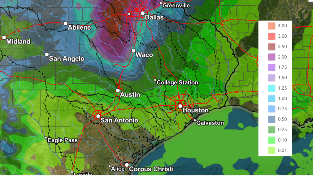
NWS Rainfall Forecast for the Period 7 pm Friday through 7 pm Next Friday:
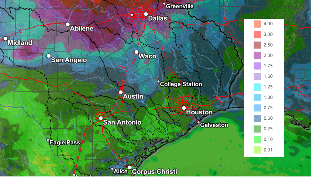
High temperatures next week are forecast to be mostly in the low and mid-90s. Lows are predicted to be in the mid-70s.
Looking out further into the second week of June, forecasts indicate the weather pattern will remain somewhat unsettled, with more chances for rain expected. High temperatures are forecast to be in the mid and upper 90s.
Tropical Weather Outlook
The Atlantic hurricane season will officially start this Sunday. Weather conditions are currently quiet across the tropical Atlantic, and tropical cyclone development is not expected over the next seven days.
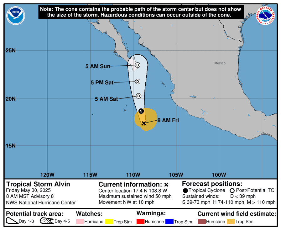
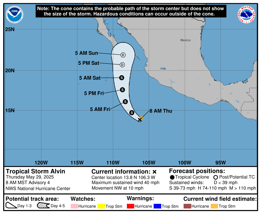
In the eastern tropical Pacific, Tropical Storm Alvin continues to churn about 385 miles south of the southern tip of Baja, California. Maximum sustained winds are near 50 mph) with higher gusts. However, weakening is forecast Friday night, and Alvin is expected to degenerate to a remnant low on Saturday as it tracks toward Baja.
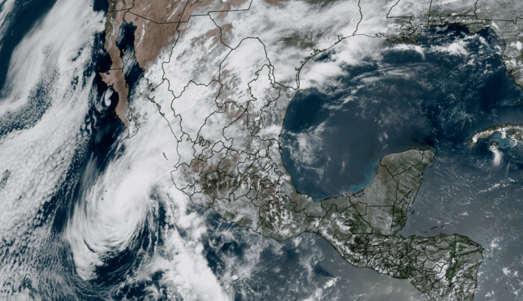
NOAA/Colorado State University/RAMMB 05/30/2025 1:30 pm CDT
Have a great weekend!
Bob
Another Round of Thunderstorms Possible Thursday Night
Weather conditions are forecast to remain quiet and dry across the region this afternoon. Expect a partly to mostly cloudy sky, with high temperatures in the upper 80s to low 90s.
Forecasters will be closely monitoring West and Northwest Texas this afternoon as a small trough of low pressure approaches from New Mexico. High resolution forecasts indicate scattered clusters of thunderstorms will develop across this general area along a southward moving cold front. The thunderstorms are forecast to eventually organize into a large complex of thunderstorms that is expected to track to the southeast overnight.
Forecasts call for the complex of storms to reach the area between San Angelo and Brownwood around midnight, spreading southeast across the Hill Country between about midnight and 3 am. The area of storms is predicted to reach the Austin/Interstate 35 corridor between about 3 am and 5 am. The storms are forecast to weaken and fall apart as they push east of I-35 and are not expected to move over the coastal plains.
There is a potential for some of the storms to be strong to severe due to the ongoing moist and unstable atmosphere. The Storm Prediction Center has placed much of West Texas and the northern Hill Country under a Slight Risk for severe thunderstorms through Thursday night. All of Central Texas, including the Austin metro, has been placed under a Marginal Risk for severe storms. Large to isolated very large hail (2-3+ inches in diameter) and severe gusts will likely be the main severe weather threats. There will also be a low potential for a couple of tornadoes.
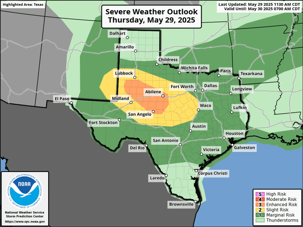
Rainfall from the overnight storms is forecast to generally average between 0.5 and 1 inch, for areas to the west of Interstate 35. However, isolated totals of 2-3 inches will be possible.
NWS Rainfall Forecast Valid through 7 am Friday:
There will be a slight chance for showers and thunderstorms Friday morning as the area of showers diminishes. Generally dry weather is forecast Friday afternoon through Saturday. A slight chance for rain will return to the forecast for Sunday afternoon.
Tropical Storm Develops in the Eastern Tropical Pacific
The first tropical storm in the eastern Pacific of 2025, Tropical Storm Alvin, has developed several hundred miles south of southwestern Mexico. Satellite imagery shows thunderstorm activity has increased and become more organized around the center. Maximum sustained winds have increased to near 40 mph. Alvin should continue to strengthen today, within a favorable environment of warm sea surface temperatures and low wind shear for about the next 24 hours. Weakening is expected to begin tomorrow as the storm moves into progressively higher shear and a drier environment with cooler SSTs. There is high confidence that the system will weaken to a remnant low before it nears the Baja California Peninsula this weekend.
Alvin should have no direct impact on Texas weather.
NWS Survey Team’s Assessment of Wednesday’s Storm in Austin
A National Weather Service survey team concluded a long track microburst, associated with a supercell, occurred from central Austin, near the Hyde Park area, southeast to just east of the Austin Bergstrom International Airport. The length of the damage was approximately 10 miles long, with a path width ranging from one mile to a maximum of around 2.5 miles on the east side of Austin. Numerous trees and powerlines were damaged along the path.
Large tree branches were snapped and a few trees uprooted that had shallow root systems. Minor shingle damage was observed on some homes. Maximum sustained winds were estimated to be between 65 and 85 mph. The Austin Bergstrom International Airport recorded a peak wind gust of 77 mph. In addition, sporadic, non-continuous wind damage was observed into northwest Austin along the supercell’s track. This consisted mainly of small to medium sized tree branches. Part of a gas station canopy collapsed onto two vehicles. Winds through this area were estimated at 55-75 mph. Sporadic wind damage was also observed to the south, associated with the rear flank downdraft. This was mainly damage to small to medium tree branches. In addition, the rear flank downdraft also below out windows on the top of the rotunda at Texas Capitol building.
There was no damage observed that was consistent with a tornado. The survey team also observed damage to tree foliage along the track of the hail core.
NOTE: The information in this statement is preliminary and subject to change pending final review of the event and publication in NWS Storm Data.
Bob
A Chance for Rain and Storms will Continue through Late Week
Storms moving across the area Monday afternoon and Monday night brought widespread heavy rain, strong winds, and some pockets of very large hail. LCRA’s Hydromet and Doppler radar estimates show the storm produced general totals of 1-2 inches across the eastern Hill Country, Central Texas, and the middle Texas coast. Some pockets of 2-2.5 inches occurred across the Hill Country between Menard and Kingsland, and also across parts of Wharton County. LCRA’s highest gauged 24-hour total was 2.94 inches, at a location in northern Gillespie County.
NWS Estimate of Rain Falling Between 7 am Monday and 7 am Tuesday:
The wave of low pressure partially responsible for Monday night’s storms has exited to the east. Tuesday afternoon’s weather is predicted to be mostly sunny. High temperatures will range from the mid-80s across the Hill Country, to the low 90s near the coast.
Another wave of rain and thunderstorms is forecast to develop late this afternoon and spread across the region late Tuesday evening and Tuesday night. A trough of low pressure currently located over northern Mexico is forecast to track northeast into Texas enhancing the development of thunderstorms. The atmosphere across West and Southwest Texas, along with northeastern Mexico is predicted to become moderately unstable by late afternoon and is expected to cause the development of an area of strong to severe thunderstorms across northeastern Mexico and Far West Texas late this afternoon. This activity is forecast to move to the east and southeast through the mid and late evening hours. This will take the storms across the southern Edwards Plateau and into the Hill Country, and possibly over portions of the Interstate 35 corridor. Unlike Monday’s night’s storms, it’s not clear how far east these next storms will move.
The atmosphere is forecast to be supportive for some of these storms to become strong to severe. The Storm Prediction Center has placed the western and southern Hill Country under a Slight Risk for severe thunderstorms through early Wednesday morning. The eastern Hill Country and the area between Austin and Victoria has been placed under a Marginal Risk for severe storms. The primary severe weather threats will be large to very large hail and damaging wind gusts. A secondary threat of an isolated tornado or two cannot be ruled out. In addition, we could also see some pockets of intense rainfall. Rainfall from these storms is forecast to generally average around 1-1.5 inches, with isolated heavier totals.
NWS Rainfall Forecast for the Period 7 pm Tuesday through 7 pm Wednesday:
Tuesday night’s storms are forecast to push off to the east Wednesday morning. Wednesday will feature a partly cloudy sky. Abundant moisture and lingering instability will yield a 40 percent chance for scattered afternoon and evening showers and thunderstorms. Expect high temperatures in the upper 80s to 90 degrees.
Additional scattered afternoon and evening showers and thunderstorms are forecast Thursday. The probability for rain will be near 50 percent. Thursday’s activity is not expected to be as widespread over as heavy as what is forecast for Tuesday night. Rain amounts are forecast to average around a quarter inch.
Additional periods of showers and thunderstorms are forecast Friday into Friday night as a weak cold front pushes south across the area. Rain amounts are forecast to only average around a quarter inch, or less.
The outlook for the weekend calls for generally dry weather as drier and more stable air spreads in behind Friday’s cold front. Expect high temperatures in the upper 80s to low 90s.
Looking ahead to next week, forecasts call for generally dry weather Monday, followed by a chance for showers and thunderstorms next Tuesday and Wednesday. Rain amounts are not expected to be very heavy. Dry and sunny weather will follow next Thursday and Friday. High temperatures next week are predicted to generally be in the mid-90s.
Tropical Weather Outlook
Weather conditions remain quiet across the tropical Atlantic and tropical cyclone development is not expected over the next seven days.
Have a good week!
Bob
Social Media