Little Rain Expected this Week. No Break from the Heat on the Horizon
May 19, 2025
Although parts of the northern Hill Country saw rain and scattered storms Friday, Saturday and Sunday, most of the region remained dry, warm, and very humid. Unfortunately, this week’s weather is not promising much in the way of rain for our area. There will be a slight chance for scattered thunderstorms across the Hill Country and Central Texas regions Monday afternoon and again on Thursday. Next week’s weather is beginning to look a bit more conducive for scattered showers and thunderstorms, with the possibility for some higher totals of rain.
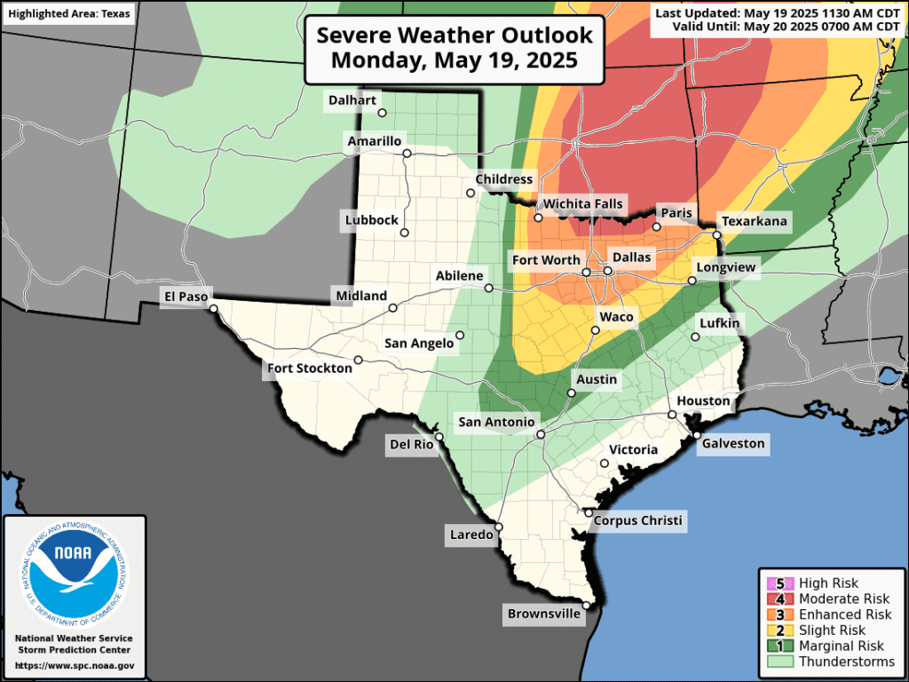
There will be a slight chance (20 percent chance) for a few scattered thunderstorms Monday afternoon and Monday evening across the Hill Country and the Austin/Interstate 35 corridor as a trough of low pressure lifts northeast out of New Mexico. This system is expected to cause an outbreak of severe weather from North Texas into the southern Plains states. Most of this activity is expected to remain well to the north of Central Texas. However, some scattered thunderstorms will be possible for the area along and west of Interstate 35 late Monday afternoon and evening as the dry line shifts east out of West Texas. The dry line is expected to serve as a focus for the development of storms. Should any thunderstorms happen to develop, they will likely become strong to severe, with large hail and damaging winds being the primary hazards.
The Storm Prediction Center has placed the area of the northern Hill Country between Brownwood, Llano, and Temple under a 2 out of 5 risk for severe storms through Monday night. Much of the rest of the Hill Country along with the I-35 corridor between Georgetown, Austin, and San Antonio has been placed under a 1 out of 5 risk.
Very spotty rain amounts of 0.5 to 1 inch can be expected.
Aside from this slight chance for thunderstorms, Monday’s weather is forecast to be mostly cloudy, warm, and humid.
- Monday’s high temperature is predicted to generally be in the low and mid-90s
- Low temperatures Tuesday morning will range from the mid-60s across the northern Hill Country, to the upper 70s near the coast
A weak Canadian cold front is forecast to push southeast across the region Tuesday morning into Tuesday afternoon. The front is expected to stall just off the middle Texas coast Tuesday night. Unfortunately, atmospheric conditions don’t appear favorable for the development of rain along the cold front. The front will bring drier and just slight cooler air for Tuesday and Wednesday. Mostly sunny conditions are forecast on both days.
- High temperatures Tuesday will range from the upper 80s across the northern Hill Country, to the mid-90s across the coastal plains
- Lows Wednesday morning will range from the low 60s across the Hill Country, to the low 70s near the coast
- High temperatures Wednesday are forecast to be in the low and mid-90s
- Lows Thursday morning will range from the upper 60s across the Hill Country, to the mid-70s across the coastal plains
Much of the area will see a 30 percent chance for a few scattered rain showers and thunderstorms Thursday afternoon and Thursday evening. This will take place as a small trough of low pressure tracks northeast across the region out of northern Mexico. Severe storms are not anticipated. Spotty rain amounts up to a quarter inch are forecast.
A sunny to mostly sunny sky and dry weather can be expected for Friday and Saturday.
- High temperatures Thursday through Saturday are forecast to generally be in the mid and upper 90s
- Lows Friday through Sunday morning are predicted to be around 70-72 degrees
The outlook for Sunday and Memorial Day calls for continued partly cloudy and hot weather. However, there will also be a 30-40 percent chance for scattered afternoon and evening rain showers and thunderstorms across the region as a series of weak atmospheric disturbances track northeast over the region out of northern Mexico. While it’s not looking like a rainout by any means, some of the storms on Sunday and Monday could produce rain amounts of 0.25 to 0.5 inches.
The weather pattern for next Tuesday through Friday looks to remain unsettled as a series of low pressure troughs move over Texas out of Mexico. These passing troughs look to cause a chance for scattered rain showers and thunderstorms next Wednesday through Friday.
High temperatures next week are forecast to generally be in the low and middle 90s.
Tropical Weather Outlook
Weather conditions remain quiet across the tropical Atlantic. Tropical cyclone formation is not expected during the next seven days.
Have a great week!
Bob
Social Media