A Chance for Severe Storms Monday Night. Sunny and Dry Tuesday through Late Week
April 1, 2024
Weather conditions are quiet as we start off the new week and the new month. However, a more active period of weather with a threat for strong to severe storms is expected to take place Monday evening and Monday night when a cold front moves across the area. In advance of the front, mostly cloudy, breezy, and warm weather will be in place Monday afternoon. Monday’s temperatures is forecast to generally reach the mid-80s. Expect a southerly wind with speeds of 10-20 mph, with occasional gusts to 30 mph.
Attention is focused on Monday evening and Monday night for the possible development of strong to severe thunderstorms across parts of the Hill Country and the Austin/Central Texas region. At that time, a large trough of low pressure pushing east out of the southern Rockies will be helping to push a Pacific cold front east out of West Texas. Forecasts call for the front to reach the western Hill Country late Monday afternoon/early Monday evening, then push southeast to the Interstate 35 corridor just before, to around midnight. The front is forecast to move southeast overnight, pushing off the middle Texas coast after daybreak Tuesday.
Monday’s analysis shows a moist and somewhat unstable atmosphere in place across North and Central Texas. High resolution forecasts call for an area of rain showers and thunderstorms to develop along the cold front when it reaches the central Hill Country this evening. The rain and thunderstorms are predicted to push southeast with the cold front overnight. The latest timing puts the rain and thunderstorms into the Austin/I-35 corridor sometime around 11 pm to 1 am.
While the greatest threat for severe storms is expected to occur across North Texas and the DFW area, some of the storms across the Hill Country and Central Texas regions may also be strong to severe. The Storm Prediction Center has placed the eastern half of the Hill Country and most of Central Texas under a Slight Risk, or a 2 out of 5 risk, for severe thunderstorms overnight. The primary severe weather threat will be large hail. Damaging downburst winds will be a secondary threat.
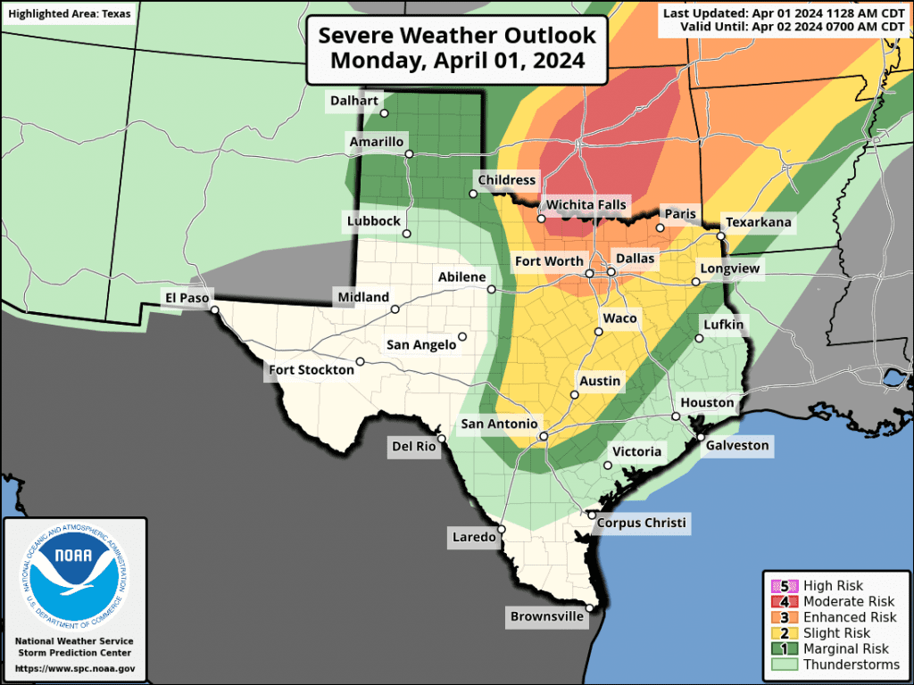
The rain and storms are forecast to end fairly quickly behind the cold front Monday night. The sky will then clear from west to east overnight. Rain amounts look to only average around a quarter inch. A couple of isolated totals of 0.5 to 1 inch will be possible.
Drier and slightly cooler air will follow the cold front on Tuesday. Highs will range from the low 70s across the Hill Country, to the low 80s near the coast.
A Canadian cold front is forecast to push southeast across the area Tuesday afternoon and Tuesday evening, ushering in breezy conditions and cooler temperatures. Expect northwesterly winds with speeds of 10-15 mph and gusts to 30 mph Tuesday night. Sunny and dry weather is forecast Wednesday through Saturday in the wake of the cold front. Expect mild days and cool nights.
- Daily high temperatures are forecast to be in the upper 70s.
- Lows Wednesday through Friday mornings will include the low and mid-40s across the Hill Country, the upper 40s across Central Texas and the upper 40s to low 50s across the coastal region.
- Lows Saturday morning are forecast to be in the mid-50s.
Forecasts call for a change in the weather pattern beginning next Sunday when a large trough of low pressure from the Pacific pushes east to the southern Rockies. The trough is forecast to lift northeast to the Plains state on Monday. This system is predicted to pull considerable clouds and moisture north from the Gulf of Mexico next Sunday into Monday—somewhat similar to what we saw this past weekend. A weak cold front associated with the trough is forecast to push east across Texas Sunday and stall somewhere just east of Interstate 35 on Monday. This atmospheric setup is expected to cause the development of scattered light rain showers across the region Sunday morning, continuing through next Monday.
Additional chances for rain are forecast next Tuesday through Thursday as another Pacific trough of low pressure slowly pushes east across Texas and the southern Plains states. Conditions appear favorable for development of widespread rain across the region with this next system. There are early indications for rain totals of 1-2 inches. Temperatures next week are expected to remain mild, with highs in the 70s to near 80 degrees and lows in the 60s.
Weather Forecast for Monday’s Total Eclipse
While it’s still too early to know the specifics for eclipse day, April 8th, confidence is increasing in a forecast for widespread clouds and possible periods of light rain. The outlook for favorable viewing conditions continues to deteriorate as the event approaches. Cloud probabilities from some of the most reliable computer forecast solutions for clear or mostly clear skies across North and South Texas are now near zero. The forecast for less than 50% sky cloud coverage is currently a 1 in 4 chance at best along the path of totality.
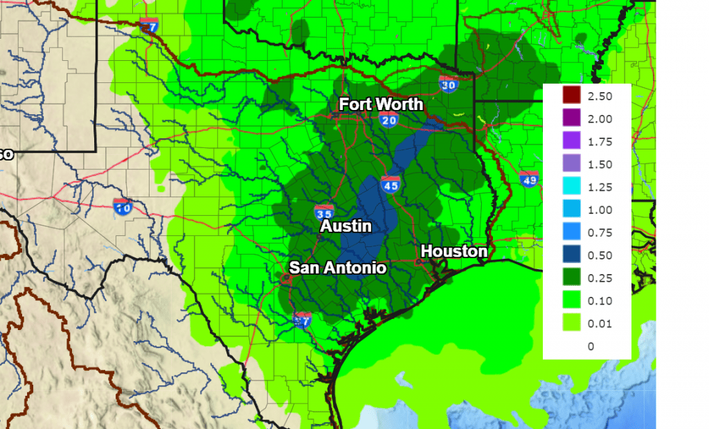
As noted in the discussion above, periods of rain are forecast Sunday through Monday. NOAA’s Weather Prediction Center is calling for widespread totals of 0.25 to 0.5 inches through 7 pm Monday.
NWS Rainfall Outlook for the Period 7 pm Saturday through 7 pm Monday:
While this outlook is incredibly disappointing, all it takes is a well-timed break in the clouds to allow for a magnificent view. For example, rain and storms disrupted the 2017 eclipse in the Kansas City area. But in the midst of the inclement weather, there were some breaks in the clouds during totality. The forecasts could still change some over the next few days.
I’ll be passing along additional weather updates throughout the week.
Bob
Social Media