A Continued Threat for Strong to Severe Storms Thursday Afternoon and Evening
March 2, 2023
An area of rain and thunderstorms developed late Wednesday night/early Thursday morning and moved over parts of the Hill Country, Central Texas, and the area southwest of San Antonio. The storms produced hail to near 1 inch at several locations, including the San Marcos area. Even larger sized-hail was noted to the southwest of San Antonio. (See hail map posted at the bottom). The area which saw the strong storms also received rain totals generally in the range of 0.25 to 0.5 inches.
The storms responsible for the early morning rain and hail have exited our area and moved into Northeast Texas. In the wake of this morning’s storms, the atmosphere has temporarily stabilized. As a result, just a slight chance for rain showers and isolated thunderstorms is forecast across the region through mid to late afternoon.
Attention now turns to the northern and western Hill Country. This is where an area of thunderstorms is forecast to develop just ahead of and along a Pacific cold front that will be pushing east out of West Texas later today. Thursday’s analysis showed many ingredients coming together over the Hill Country and Central Texas that will promote the development of strong to severe thunderstorms. High-resolution forecasts call the area of thunderstorms to organize into a line of strong to severe storms that will then spread east across the Hill Country, Central Texas, and coastal regions.
- Forecasts call for the line of storms to track across the Hill Country roughly between about 4 pm and 7 pm.
- The line of storms is forecast to spread across the Austin/Interstate 35 corridor roughly between 6 pm and 8 pm, and the Bastrop/ La Grange area roughly between 8 pm and 10 pm.
- The line of storms is forecast to spread across the coastal plains region roughly between 11 pm and 2 am.
The Strom Prediction Center has placed most of the Hill Country and all of Central Texas, plus Colorado and Wharton Counties, under a Slight Risk (a 2 out of 5 risk) for severe thunderstorms through Thursday night. SPC forecasters are calling for an Enhanced Risk (a 3 out of 5 risk) for severe thunderstorms for the area just north and northwest of Austin, extending north to Waco and Mineral Wells. Much of Williamson, eastern Burnet, San Saba, Mills, and Brown Counties are included in the Enhanced Risk area.
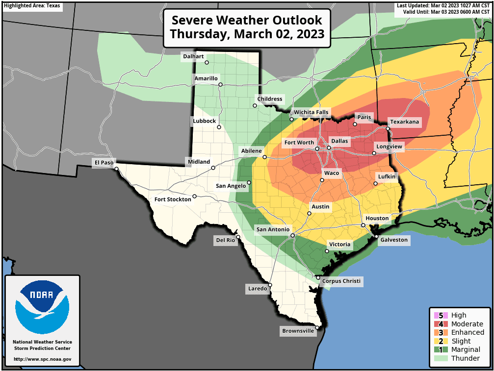
The primary severe weather threats are forecast to large to very large hail and damaging downburst winds. However, an isolated tornado or two cannot be ruled out.
Rain amounts from this evening and tonight’s storms are forecast to generally average around a quarter inch, with isolated totals of 0.5 to 1 inch possible.
Behind the rain and storms, a strong pressure gradient is expected to cause breezy to windy conditions.
The National Weather Service has posted a Wind Advisory for the Hill Country and the Austin/Interstate 35 corridor from 3 pm to midnight. Here, expect westerly winds of 20-30 mph, with gusts to 45 mph.
To the west and northwest of the Hill Country, the NWS has posted a High Wind Warning for the Concho Valley and most of West Texas. Here, westerly winds with speeds of 30-40 mph and gusts to 60 mph are forecast.
Sunny and breezy weather is forecast Friday. Expect northwesterly winds at 15-25 mph, with occasional gusts to 40 mph. Winds speeds are forecast to decrease to around 5-10 mph Friday evening.
Bob
Path and Radar Estimated Hail Size from Thursday Morning’s Storms:
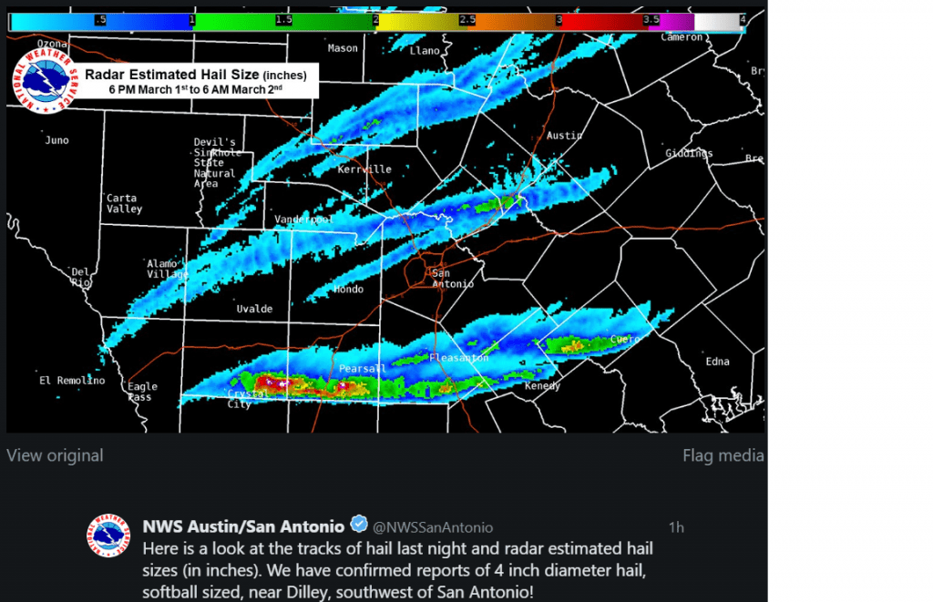
(Courtesy National Weather Service Austin/San Antonio)
Social Media