A Pleasant Weekend Trending to an Increasing Chance for Rain Next Week
April 5, 2024
Here’s an update on weather conditions for Monday’s Total Eclipse, plus an outlook for next week. The weather pattern looks to be trending wet and quite active shortly after Monday’s eclipse.
Eclipse Day Weather Highlights
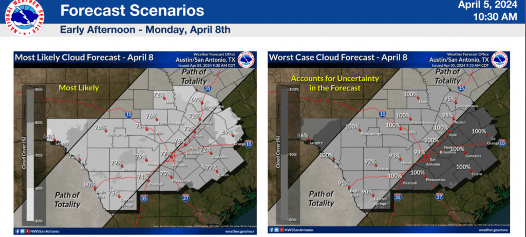
- The latest forecast solutions are showing little change in the weather outlook for Monday. Forecasts continue to call for a mostly cloudy sky across the region through the midday hours on Monday.
- While some breaks in the low-level clouds will be possible, considerable high-level clouds are still forecast to be in place, creating less than ideal conditions for viewing the eclipse.
- Some fluctuation in the forecast will still be possible over the next couple of days, but chances for optimal sky conditions to view the eclipse will be less than 10 percent.
Forecasts continue to call for a trough of low pressure to move into the Southwestern U.S. late Sunday into Monday. Out ahead of the trough, southerly winds off the Gulf of Mexico are predicted to increase beginning Sunday evening, causing a surge of moisture and low, dense clouds into Central Texas and the Hill Country. While a few small breaks in the low clouds will be possible by midday Monday, forecasts continue to call for a considerable high-level clouds to also blanket the sky. Unfortunately, even these high clouds are predicted to be somewhat thick and unfavorable for getting a good view of the eclipsed sun.
Any breaks in the clouds that might happen to develop midday will be short-lived. Forecasts call for clouds to quickly thicken up by mid-afternoon. There will be a 50 percent chance scattered rain showers and thunderstorms across the region after about 3 pm. Some of these storms may even be strong to severe.
The National Weather Service’s cloud forecast for early Monday afternoon calls for at least 75 percent cloud coverage across the area in its most likely scenario:
Weather Discussion for the Weekend and Next Week
Sunny and breezy weather will be in place Friday afternoon. Expect southerly winds at 10-15 mph, with occasional gusts to 25 mph Friday afternoon through Friday night. High temperatures are forecast to be in the low and mid-80s. Lows Saturday morning will be in the upper 50s to low 60s.
On Saturday, a trough of low pressure is forecast to lift northeast from New Mexico up to the Central Plains, dragging a Pacific cold front into the state. Forecasts call for the front to reach the western Hill Country Saturday evening, moving across Central Texas Saturday night. The front is predicted to stall just east of Interstate 35 Sunday morning, then move back to the north as a warm front Saturday night. With limited moisture in place, no rain is forecast with the front.
Saturday’s weather will include widespread morning clouds, followed by a partly cloudy sky in the afternoon. It will be another breezy and warm day. Expect southerly winds at 10-20 mph, with occasional gusts to 30 mph through Saturday evening. Wind speeds should decrease after midnight Saturday night. The sky is predicted to be sunny to partly cloudy on Sunday.
- High temperatures Saturday are forecast to be near 80 degrees.
- Lows Sunday morning will include the low 50s across the Hill Country, the upper 50s to low 60s across Central Texas, and the low 60s across the coastal plains.
- High temperatures Sunday are forecast to be in the low 80s.
- Lows Monday morning will include the mid and upper 50s across the Hill Country, the upper 50s to low 60s across Central Texas, and the mid-60s across the coastal plains.
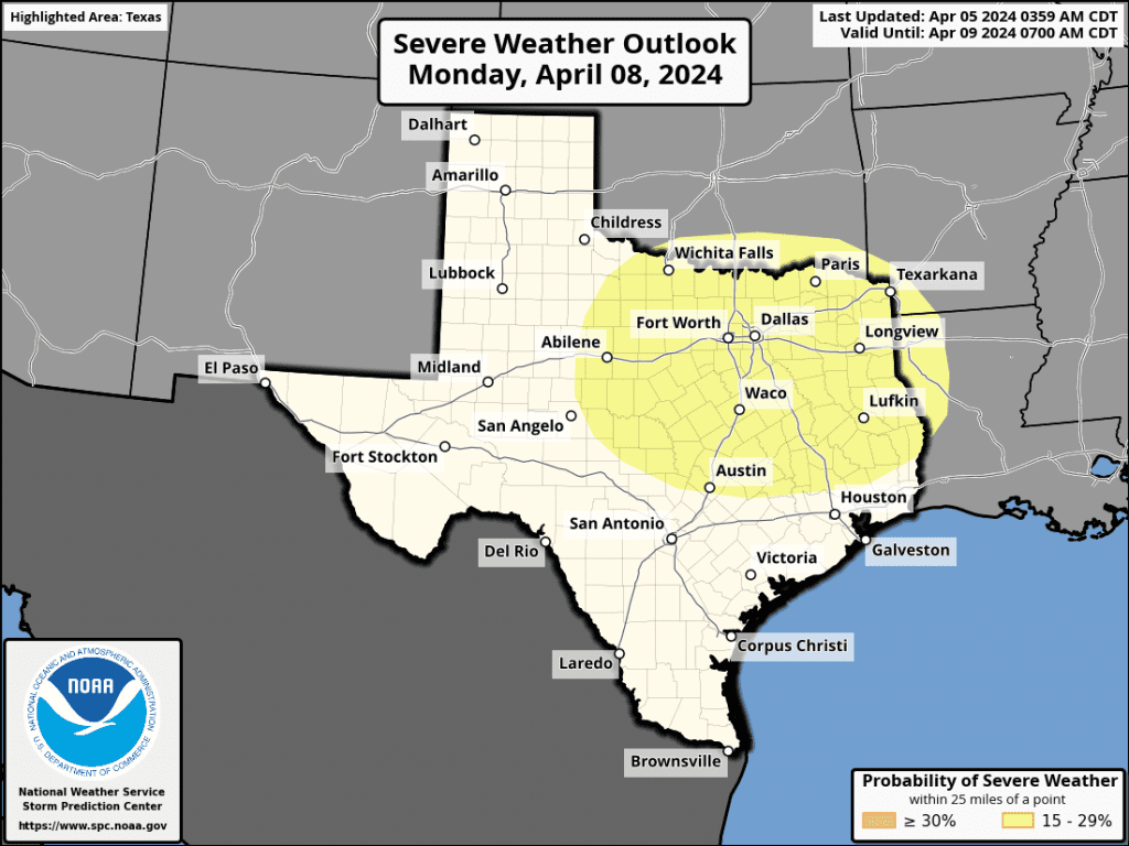
A large trough of low pressure is predicted to move into the Southwestern U.S. late Sunday and become nearly stationary. As mentioned in the eclipse discussion, flow out ahead of the trough is expected cause a surge of clouds and moisture north into Central Texas and the Hill Country beginning Sunday night, continuing throughout the day on Monday. As moisture levels increase Monday afternoon, an expansive area of light rain showers and scattered thunderstorms is forecast to develop across the region and continue through Monday night. The probability for rain will be around 50 percent. There are early indications some of the developing thunderstorms could be strong to severe. Rain amounts up to a quarter inch are forecast. The Storm Prediction Center is highlighting the northeastern Hill Country and the northern counties of Central Texas, including Austin, for the possibility of severe storms:
There will be an increased chance for periods of rain showers and scattered thunderstorms across the entire region Tuesday through Wednesday as the southwestern trough slowly wobbles east into West Texas. The combination of the slow-moving trough and a very moist flow off the Gulf of Mexico is expected to result in multiple rounds of rain showers and thunderstorms Tuesday through Wednesday. Moderate to occasionally heavy rain is forecast. The rain is forecast to linger into Thursday morning, then wrap up Thursday afternoon as the upper trough finally moves off to the Mississippi Valley.
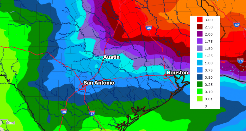
There will be a potential for significant amounts of rain. The latest National Weather Service’s forecast calls for widespread totals of 1-2 inches, with isolated higher totals possible.
NWS Rainfall Forecast Valid through 7 pm Next Friday:
Dry and breezy weather is forecast for next Thursday afternoon and Friday. Sunny weather looks to continue into next weekend as well. Expect high temperatures in the 70s, with lows in the 50s.
Colorado State University Hurricane Outlook Was Released Thursday
Dr. Phil Klotzbach and Colorado State University released their outlook for the upcoming hurricane season on Thursday, and it is expected to be an extremely active season!!! The outlook calls for 23 named storms, 11 of them hurricanes, and 5 major hurricanes. Klotzbach stated this is most active forecast he has ever made. The combination of unusually warm sea surface temperatures across the Atlantic and a switch to La Nina by the heart of the season were behind the high numbers forecast.
Bob
Social Media