A Threat for Severe Thunderstorms Monday Afternoon and on Tuesday
April 8, 2024
While much focus in the short term will be on today’s solar eclipse (and rightfully so), full attention needs to be placed on an episode of potentially significant severe weather likely to affect Central Texas, the Hill Country, and the coastal Plains region beginning mid to late afternoon, continuing into tonight and again on Tuesday. It should be emphasized that only a short time period may exist between eclipse events and the initiation of strong to severe thunderstorms, so those with outdoor events may wish to encourage quick departures. The next 48 hours look to have the most favorable severe weather setup our area has seen so far this calendar year.
Weather Discussion
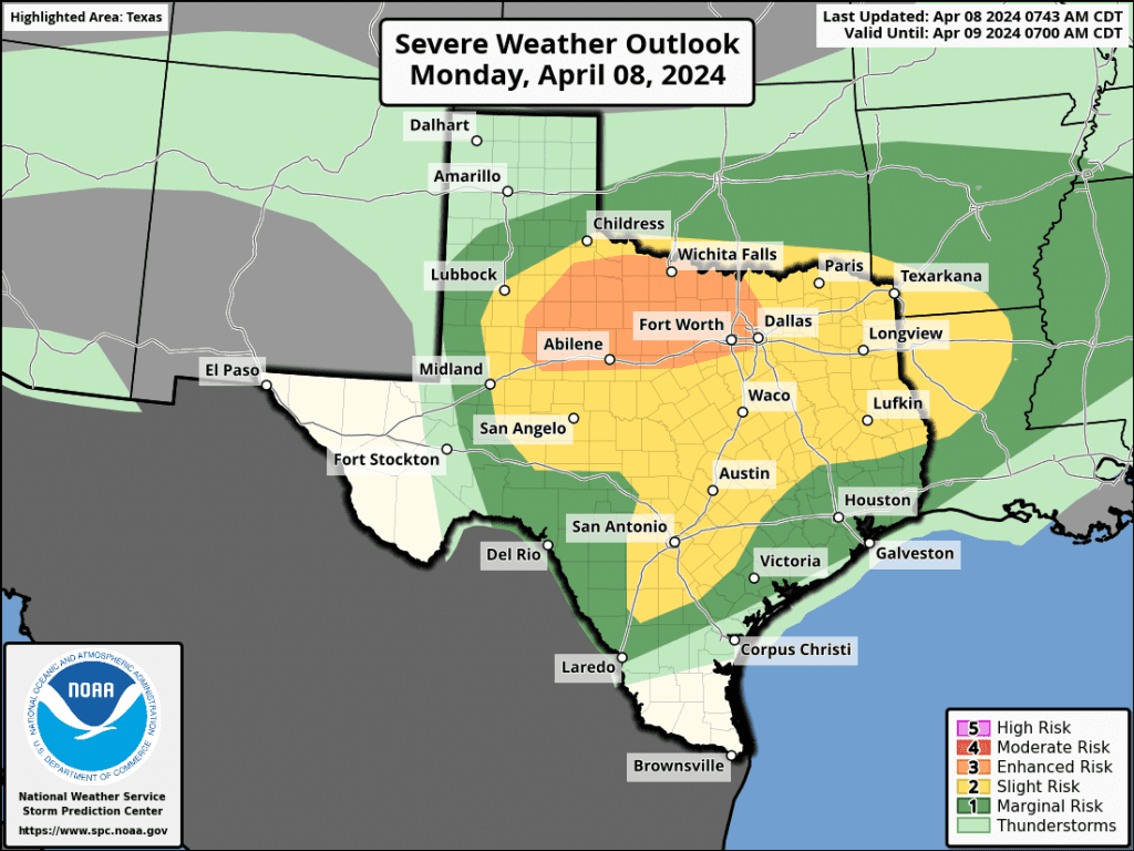
While the weather is predicted to stay dry through the eclipse window, changes are forecast to quickly take place by mid-afternoon as moisture increases ahead of an approaching trough of low pressure. High-resolution forecasts call for rain and thunderstorm to develop across the middle Texas coast by early afternoon, with the activity spreading north to parts of Central Texas and the eastern Hill Country during the mid and late afternoon. Forecasts call for the atmosphere to become increasingly unstable this afternoon, and could support the development of scattered strong to severe thunderstorms. Today’s primary severe weather threats will be large hail and dangerous cloud to ground lightning. There will also be a low-end threat for a couple of isolated tornadoes—mainly for areas north and northeast of Austin. The Strom Prediction Center has placed much of the area under a Slight Risk, or 2 out of 5 risk for severe thunderstorms through Monday night.
Most forecast solutions call for the thunderstorm activity to weaken early this evening, with a break from rain and storms expected late evening till just after midnight.
Forecasts call for the atmosphere across the region to become increasingly unstable beginning late tonight and toward daybreak Tuesday. Isolated to scattered thunderstorms are predicted to develop across the area during this time period. Showers and thunderstorms are then forecast to expand in areal coverage through the morning hours and into the afternoon. Several parameters will be in place that are expected to allow some of these storms to become strong and severe. The Storm Prediction Center has placed the Austin metro and much of Central Texas under an Enhanced Risk, or a 3 out of 5 risk, for severe thunderstorms. The rest of the region has been placed under a 2 out of 5 risk for severe thunderstorms.
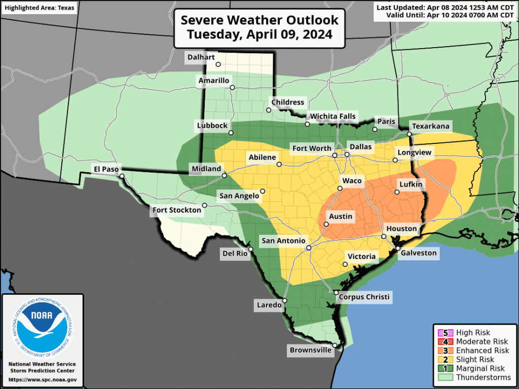
While large hail, damaging winds, and dangerous lightning will be the primary severe weather threats, there will also be a secondary threat for isolated tornadoes—mainly in the Enhanced Risk area.
A lull in the precipitation is forecast to take place late Tuesday afternoon into Tuesday evening. However, another period of rain and thunderstorms is forecast to occur Tuesday night into Wednesday morning. Some of the storms may also be strong to severe. The rain activity is predicted to taper off by midday Wednesday as the trough to our west finally moves off to the northeast.
Do note, moderate to heavy rain will be possible from some of the storms both Monday afternoon and again on Tuesday. A few spots could see heavy downpours which could lead to some isolated flash flooding. In general, totals of 1-1.5 inches are forecast across much of the area through Wednesday morning.
Fingers crossed for some breaks in the clouds to persist for today’s eclipse!
Bob
Social Media