A Wet and Unsettled Weather Pattern Forecast Friday through Sunday
March 14, 2024
Key Messages
- There will be a very low-end threat for the development of isolated strong to severe thunderstorms across the eastern Hill Country and the northern counties of Central Texas (including Austin) late Thursday afternoon and evening.
- Friday afternoon through Friday night will bring a greater potential for scattered strong to severe thunderstorms to the entire region. Primary severe weather threats will be large to very large hail and damaging winds.
- Some of Friday’s storms could produce locally heavy rainfall, with high rainfall rates and the potential for isolated flash flooding.
- There is high confidence for periods of widespread rain and scattered thunderstorms across the region Saturday through Sunday. Periods of moderate to heavy rainfall will be possible.
- Total rainfall between Thursday and Sunday is forecast to average close to 2 inches for the area from eastern Hill Country to the middle Texas coast. Isolated higher totals will be possible.
Discussion
An active weather pattern is coming together that will offer up several opportunities for rain showers and scattered thunderstorms late Thursday afternoon through late Sunday.
Thursday will feature a mostly cloudy to overcast sky as clouds and moisture spread into Texas off the Gulf and the eastern Pacific. Today, forecasters will be closely monitoring progress of the dry line as it pushes east out of West Texas. Predictions call for the dry line to reach a location across the western or central Hill Country by late afternoon. The atmosphere will be primed for thunderstorms to develop along the boundary this afternoon. However, a strong stable layer in place in the lower atmosphere is expected to limit the development of thunderstorms along and east of the dry line. There will be slight (20 percent) chance a couple of isolated thunderstorms could break through the cap and develop somewhere across the northern Hill Country and possibly as far east as the Austin area. Should any thunderstorms happen to develop, they are expected to quickly become severe. The primary severe weather threats will be large hail and damaging downburst winds. There will be a 30 percent chance for scattered rain showers and isolated thunderstorms across the region late Thursday evening through daybreak Friday.
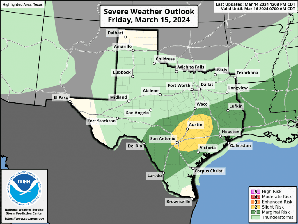
For Friday, scattered rain showers are forecast to develop and spread north across the area throughout the morning. By afternoon, there will be an increasing chance for widespread rain showers and scattered thunderstorms across northern and central Hill Country along with the Austin/Central Texas region as a weak cold front slowly sags south out of North Texas. Atmospheric conditions ahead of the front are forecast to be favorable for the development of strong to severe thunderstorms across the region, but especially across Central Texas. The Strom Prediction Center has placed all of Central Texas, including Austin, under a Slight Risk (a 2 out of 5 risk) for severe thunderstorms Friday afternoon into Friday evening. The remainder of the region has been placed under a 1 out of 5 risk. Severe weather threats will mainly be large to very large hail and damaging winds. However, an isolated tornado or two cannot be completely ruled out.
Friday night, the focus for moderate to heavy rain and scattered thunderstorms is expected to shift to the southern half of Central Texas and the middle Texas coast as the weak cold front continues to sag south.
Rainfall Friday through Friday night is forecast to generally average between 0.5 and 1 inch, with isolated totals to near 2 inches possible
A cloudy and wet pattern is forecast to continue Saturday through Sunday as additional waves of low pressure spread north out of Mexico. The first of these waves is forecast to arrive Saturday morning and is expected to cause the development of widespread rain showers and scattered thunderstorms across the region The activity is predicted to continue off and on Saturday afternoon through about midday Sunday. The probability for rain through the period will be around 70 percent. Rain amounts Saturday through Sunday are forecast to generally average around 1 inch, with isolated totals to near 2 inches possible.
The chance for rain is forecast to decrease Sunday afternoon into Sunday evening as drier and slightly cooler air spreads south behind a weak cold front.
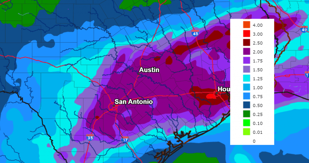
The National Weather Service’s rainfall forecast for the period between Thursday and Sunday calls for widespread totals of around 1.5 to 2 inches for the eastern Hill Country, all of Central Texas, and the middle Texas coast. Slightly lower totals are forecast for the western and central Hill Country. Isolated totals to near 4 inches will be possible.
NWS Rainfall Forecast Valid through 7 am Tuesday:
Looking out into next week, mostly cloudy and dry weather is forecast Monday. There looks to be a slight chance for rain next Tuesday, followed a better chance for rain next Wednesday into Thursday.
Bob
Social Media