A Wet Week is Forecast, with Significant Totals of Rain Expected this Weekend
May 9, 2023
- Rain amounts of 1 to 2 inches with very localized amounts of 3 to 5 inches will be possible this afternoon through Wednesday for areas along and east of Interstate 35.
- Locally heavy rainfall with flash flooding the main concern. There severe weather threat has diminished, but an isolated strong storm with small hail and gusty winds will still be possible.
- Heavier and more significant rain and higher impact flooding will be possible across the area Friday through Sunday.
A wet and soggy May weather pattern is beginning to take shape across Central and South Texas, and this pattern is predicted to continue through the upcoming weekend and even into Monday. Waves of moderate to occasionally heavy rain are forecast this afternoon and Wednesday primarily for areas along and east of Interstate 35. However, a more widespread coverage of moderate to heavy can be expected across the region Friday through Sunday.
The wet pattern began across parts of the Hill Country Monday evening and Monday night when an area of showers and thunderstorms developed persisted over the area between Brownwood and Coleman, south to Bandera and Leakey. Totals across this large area through 7 am Tuesday generally averaged between 0.5 and 1.5 inches. LCRA’s highest gauged total was 3.37 inches at a location in northwestern Kimble County. Another area of heavy rain occurred across central Fayette County Monday evening when a persistent area of thunderstorms brought heavy rain and hail to central Fayette County. Here, totals of 2-2.5 inches were observed.
This Afternoon through Wednesday:
The wet pattern this afternoon and Wednesday will be driven by an area of low pressure in the middle and upper atmosphere that has developed over south Central Texas. This feature is forecast to remain in place through Wednesday afternoon. The low will pull abundant Gulf moisture north into Central Texas, causing the development of waves of moderate to occasionally heavy rain. This will mainly be for areas along and east of Interstate 35, with a somewhat lesser coverage of rain expected across the Hill Country. The probability for rain and thunderstorms is forecast to be near 60 percent this afternoon, 30 percent, tonight, and 60 percent Wednesday.
Rain amounts this afternoon through Wednesday afternoon are forecast to generally average between 1 and 2 inches, with isolated totals of 3-5 inches possible for areas along and east of I-35. For the Hill Country, totals are forecast to average around a half an inch.
The threat for severe storms appears low this afternoon through Wednesday. However, an isolated strong storm here or there containing small hail and gusty winds cannot be ruled out.
Thursday and Thursday Night
Forecasts are calling for the chance for rain to decrease some across the area Thursday as the upper low weakens and dissipates. There will still be a 30 percent chance for scattered afternoon rain showers and isolated thunderstorms due to the moist atmosphere, but rain amounts should average less than a quarter inch.
Friday through Monday
This is shaping up to be a very active, wet period across the region as a large trough of low pressure sinks south into northern Mexico. The trough is forecast to pull considerable moisture north from the Gulf and the eastern Pacific, setting the stage for periods of moderate to heavy rain. A series of small waves of low pressure are forecast to rotate through the large trough and move across Texas, causing waves of rain and thunderstorms through the weekend.
The first wave of rain and storms is forecast to spread across West Texas and the Edwards Plateau region Friday afternoon. This system is forecast to cause a widespread area of rain showers and thunderstorms that looks to spread east across the Hill Country, Central Texas, and coastal regions Friday night through Saturday morning. Forecast solutions call for additional waves of showers and thunderstorms to spread across the region Saturday afternoon through Sunday and even into Monday. Each of these waves will have the potential to cause significant totals of rain.
Weather Prediction Center rainfall forecasts are calling for totals of 2-3 inches Saturday, 1-3 inches Sunday, and around a quarter to a half inch on Monday.
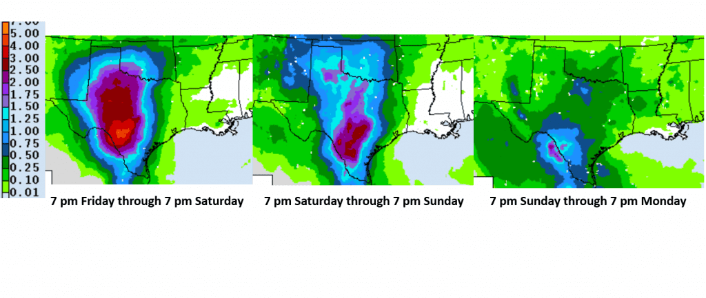
As the totals add up over the weekend, the chance for flooding and flash flooding will increase.
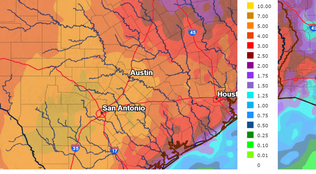
The National Weather Service’s 7-day rainfall forecast, taking into account the rain throughout the week and this weekend, calls for widespread totals of 5-7 inches across most of the Hill Country and Central Texas, including the Austin area. Totals of 3-5 inches are forecast along the middle Texas coast.
NWS Rainfall Forecast for the Period 7 pm Tuesday through 7 pm Next Tuesday:
The rain is forecast to taper off late Monday as the trough over Mexico lifts off to the northeast. Generally dry weather is forecast next Tuesday through Friday.
Stay tuned as the weekend rain event become better defined ahead of the weekend.
Bob
Social Media