Adios La Niña! Could El Niño be on the Horizon?
March 9, 2023
La Niña has ended! This was the announcement from the National Weather Service’s Climate Prediction Center Thursday. La Niña has persisted for more than three years and helped bring drier than-normal conditions to much of Texas during its reign. But recently La Niña has transitioned to neutral, allowing NOAA to issue its “Final La Niña Advisory”.
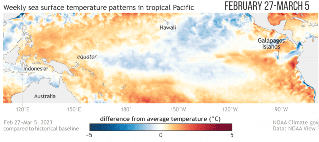
Observations from February 2023 showed the tongue of cooler than-average sea surface temperatures (SSTs) stretching across the eastern and central tropical Pacific associated with La Nina has weakened, with the coolest waters now covering a small area around the International Date Line. In contrast to the central Pacific, SSTs in parts of the eastern Pacific Ocean have trended significantly above average, with some values more than 1°C above normal.
In the last month, area-averaged temperatures below the surface trended slightly above average—a good sign La Nina is weakening/dissipating. Meanwhile up in the atmosphere, there are still some indications of a La Niña-like strengthened Walker circulation, with more rain and clouds than average over Indonesia, less clouds and rain over the central Pacific, and enhanced trade winds. However, without the cooler sea surface temperatures characteristic of La Niña, it’s likely this pattern will diminish in the coming weeks.
In Thursday’s CPC update, the forecaster consensus was very confident a neutral Pacific will continue through spring and into early summer. (a 96 percent confidence). A neutral Pacific means the tropical Pacific Ocean will not be an actor on the world’s climate stage. The lack of El Niño or La Niña means that there is no seasonal-scale influence from the Pacific to push around the global atmospheric circulation and influence seasonal climate patterns.
It is interesting to note many computer-forecast climate models are predicting a transition from neutral to El Niño sometime later this year. However, right now is a very tricky time of year for the models, due to the something called the “spring predictability barrier.” ENSO events peak in the winter and tend to decay and transition in the spring, so models often don’t have a lot of strong signals to go on. The CPC forecaster consensus favors ENSO-neutral conditions holding on through summer 2023, with elevated chances of an El Niño developing afterwards. The smaller chances of El Niño relative to the model predictions this summer are due to the tropical Pacific atmosphere situation still being somewhat consistent with a cool/La Niña-like state. However, it is possible that strong warming near South America may portend a more rapid evolution toward El Niño sometime this summer.
The situation will be closely monitored in the months ahead.
Bob
Social Media