An Increased Threat for Severe Thunderstorms Thursday
March 1, 2023
Weather conditions appear to be coming together that will create an increasing threat for strong to severe thunderstorms across most of our region late Wednesday night through Thursday evening. This severe weather threat is being generated by a strong trough of low pressure that is predicted to move from the Desert Southwest to the southern Plains states Wednesday night through Thursday. The trough is expected to pull abundant moisture north from the Gulf, while at the same time promote atmospheric lift across North and Central Texas.
Two periods of strong to possibly severe and thunderstorms are forecast. The first period is predicted to take place across the Hill Country and Central Texas regions sometime between late Wednesday night and mid-morning Thursday, when a small wave of low pressure tracks northeast out of Mexico, out ahead of the large trough located further to the west. High-resolution forecasts call for a large area of rain and thunderstorms to develop out across the Edwards Plateau around 2 or 3 am, with the activity then spreading east-northeast across the Hill Country and parts of Central Texas during the hours just before and just after sunrise. Some of these thunderstorms could be severe, with the greatest severe weather threat being large hail. The storms are forecast to exit the region by late morning.
A partly to mostly cloudy sky along and warm temperatures are forecast late Thursday morning through Thursday afternoon. Afternoon temperatures are predicted to reach the mid and upper 80s.
The second period for strong to severe thunderstorms is expected to begin across the Hill Country early to mid-Thursday afternoon when a Pacific cold font associated with the upper trough pushes east out of West Texas. Forecasts call for an area of strong to severe thunderstorms to develop ahead of and along the advancing front. Thunderstorms are forecast to spread east to Central Texas late Thursday afternoon into Thursday evening, and to the coastal plains region Thursday evening and toward midnight. The primary severe weather threats look to be damaging downburst winds and large hail. However, an isolated tornado or two will also be possible. The severe weather threat will end once the line of storms exits the area. Periods of light rain may extend into Thursday evening. All of the rain should come to an end by midnight Thursday night as the front pushes east into the Gulf of Mexico.
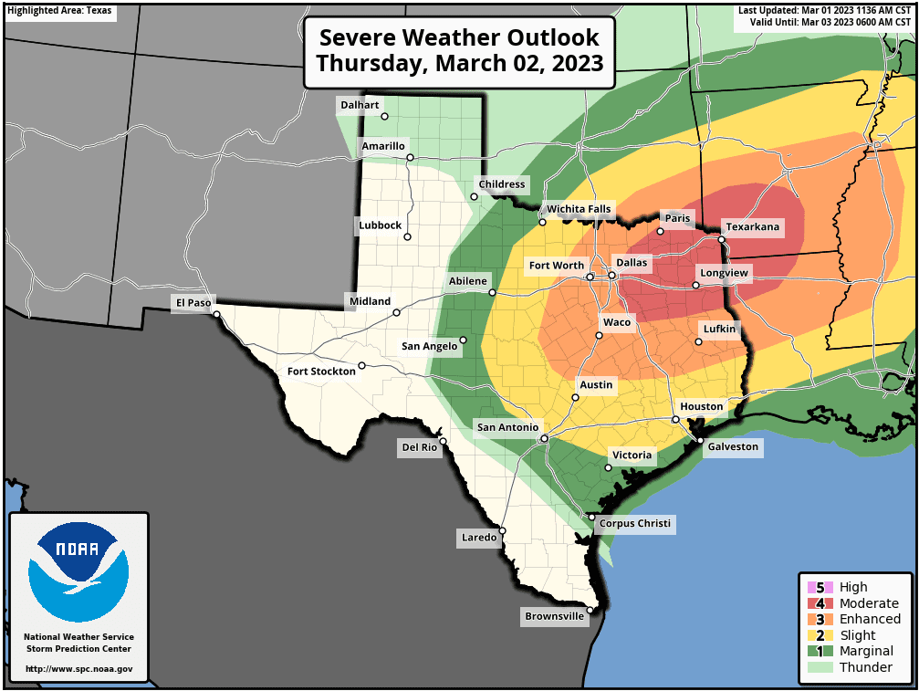
The Storm Prediction Center has raised the severe weather threat across our region Thursday. The severe weather outlook now shows a Slight Risk (a 2 out of 5 risk) for most of the Hill Country, all of Central Texas, and parts of the coastal plains region including Colorado and Wharton County Counties, through Thursday evening. The outlook places the area just north and northwest of Austin (northern Williamson, eastern Burnet, Lampasas, and eastern Mills Counties under an Enhanced Risk (a 3 out of 5 risk) for severe thunderstorms through Thursday evening.
Rain amounts Thursday are forecast to generally average between 0.25 and 0.5 inches, with a few isolated heavier totals to near 1 inch possible.
Do note strong winds are forecast to develop along and behind the cold front late Thursday afternoon through Thursday evening. The National Weather Service has posted a Wind Advisory for much of the Hill Country and the Interstate 35 corridor from 3 pm Thursday through midnight Thursday night. Expect southerly winds at 15-20 mph, with gusts to 30 mph Thursday afternoon, and westerly winds at 15-25 mph with gusts to 40 mph Thursday evening. Breezy conditions will continue Friday, with northwesterly winds gusting up to 30 mph. Wind speeds should decrease Friday evening and Friday night.
Bob
Social Media