Arctic Outbreak Monday Update
JAN. 20, 2025
Weather Highlights
- Precipitation is predicted to develop and spread north across the region Monday evening into early Tuesday
- A mix of rain, freezing rain, sleet, and snow is forecast Monday evening
- Most of the precipitation should transition to snow after midnight Monday night
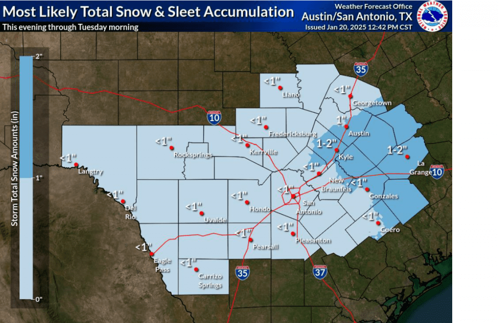
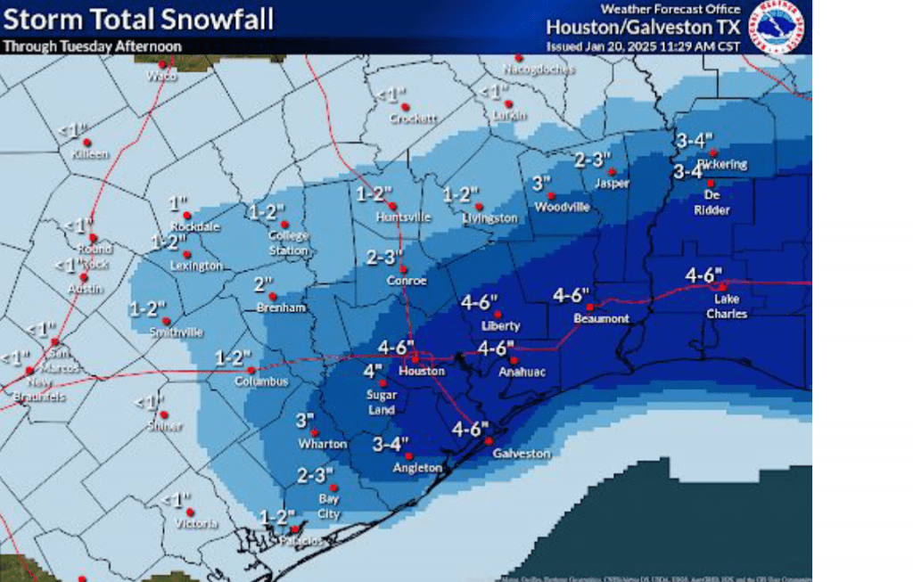
- The most likely snow and sleet accumulations are expected to range from less than a half inch across the eastern Hill Country, to around 1 inch across Austin and Central Texas area, to between 1 and 3 inches for areas south of Interstate 10
- Ice accumulations are forecast to only be around a trace in the Austin area. To the southeast of Austin, ice accumulations are forecast to range between 0.01 inch and 0.1 inch
- All of the precipitation should come to an end by mid-morning Tuesday
- Very cold temperatures are forecast Tuesday night. Readings could reach 15 degrees Wednesday morning over the area between La Grange and Wharton due to lingering snow cover
- Dry and milder will develop Thursday and continue into the weekend
…A winter storm warning will be in effect for the Austin/Interstate 35 corridor and areas southeast to the coast from 6 pm Monday through 6 pm Tuesday…
…A Winter Weather Advisory will be in effect for the eastern Hill Country from 6 pm Monday through 6 pm Tuesday…
Discussion
Clouds spread north across the area sooner than expected Monday and have kept temperatures from warming significantly. Monday’s clouds are the result of a trough of a trough of low pressure advancing southeast out of the Desert Southwest. Monday’s forecasts are calling for the system to move in and depart a little faster than previously expected.
With the trough of low pressure moving a bit faster than previously expected and with forecasts showing somewhat less moisture available, precipitation predictions have come down slightly. Nevertheless, high resolution forecasts show a very messy winter weather event unfolding Monday evening, continuing through the overnight hours. Light precipitation is forecast to develop across the coastal Plains early Monday evening as the overrunning pattern initiates. The precipitation is predicted to expand north into Central Texas and the eastern Hill Country late evening and toward midnight.
- For areas south of Interstate 10, the precipitation is forecast to start off as a mixture of freezing rain and sleet Monday evening, with the precipitation becoming sleet and snow showers after midnight.
- Across Central Texas, a mixture of light rain, sleet, and snow showers is forecast Monday evening, with the precipitation becoming mostly snow showers after midnight
- Across the eastern Hill Country, light snow showers are forecast to develop Monday evening and continue overnight.
The precipitation is forecast to end from west to east beginning around daybreak Tuesday.
Total snow/sleet and ice accumulations are forecast to total around a half inch across the Hill Country. For most of Central Texas, accumulations are forecast to average around 1 inch, with some totals up to 2 inches in the area between Bastrop and La Grange. For areas south of Interstate 10, accumulations of 1-3 inches are forecast.
Total ice accumulations are predicted to be around a trace across the eastern Hill Country and around 0.01 inch across the Austin/Interstate 35 corridor. Ice accumulations are forecast to be between 0.01 and 0.1 inches over the area stretching between La Grange and Matagorda.
Travel may become hazardous and difficult Monday night through midday Tuesday. Travel impacts may return Tuesday night into Wednesday morning as any remaining moisture on roads refreezes.
Clouds are forecast to decrease and the sky become mostly sunny Tuesday afternoon. Despite the sun, temperatures will stay cold, with highs in the mid and upper 30s. Expect a northerly wind at 10-15 mph, with gusts to 30 mph.
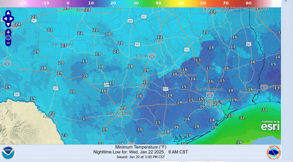
Clear and very cold temperatures are predicted for Tuesday night into Wednesday morning as the sky clears and winds diminish. Low temperatures Wednesday morning are forecast to generally be between 18 and 20 degrees across the Hill Country and Central Texas. Interestingly, some of the coldest readings down to near 15 or 16 degrees are predicted to occur across the coastal plains region, where considerable frozen precipitation will likely still be on the ground.
Minimum Temperatures Forecast Wednesday Morning:
Sunny and milder weather will develop Wednesday afternoon with highs in the 40s. Sunny and dry weather continue Thursday through Friday. Lows Thursday morning will generally be in the mid-20s. Highs Thursday are forecast to be in the upper 40s to low 50s, warming to the upper 50s on Friday.
Bob
Social Media