Daily Chances for Thunderstorms Will Continue into Next Week. Warm and Humid!
May 5, 2023
The weather pattern is expected to remain somewhat unsettled for the next several days, featuring a daily chance for scattered afternoon and evening thunderstorms. The activity is forecast to generally be hit and miss, with no widespread storms or heavy rain expected through the middle of next week. However, storms over the next few days will have the potential to be strong and severe.
Totals through the middle of next week are forecast to generally average between 0.5 and 1 inch across the Hill Country and Central Texas regions, and be around a quarter inch or less across the coastal plains. Forecasts do point toward the development of more widespread and somewhat heavier rains late next week.
It’s going to be feeling just like summer over the next few days as temperatures climb to or just above 90 degrees. The warm temperatures will combine with high humidity levels to produce uncomfortable conditions. On the plus side, breezy south winds of 10-20 mph are forecast to persist into the middle of next week.
Here’s a breakdown of the upcoming week:
This Afternoon through Tonight
Today’s atmospheric setup is very similar to what was in place on Thursday. Today’s atmosphere is quite moist and somewhat unstable. However, there is little forcing to initiate thunderstorms directly over our area. The dry line stretches from the Texas South Plains into northeastern Mexico. A weak trough of low pressure is forecast to track northeast out of Mexico late this afternoon and evening and this feature is expected to spark the development of scattered thunderstorms along the dry line during the mid to late afternoon. The thunderstorms are forecast to track northeast across the Hill Country and into parts of Central Texas during the late this afternoon and evening. Unfortunately, the high-resolution forecast models are not able to resolve exactly which areas will see storms and which will not. Generally speaking, the probability for thunderstorms late this afternoon and evening will be around 30-40 percent at any given spot across the Hill Country and Central Texas. Across the coastal plains, the probability for rain will only be 20 percent.
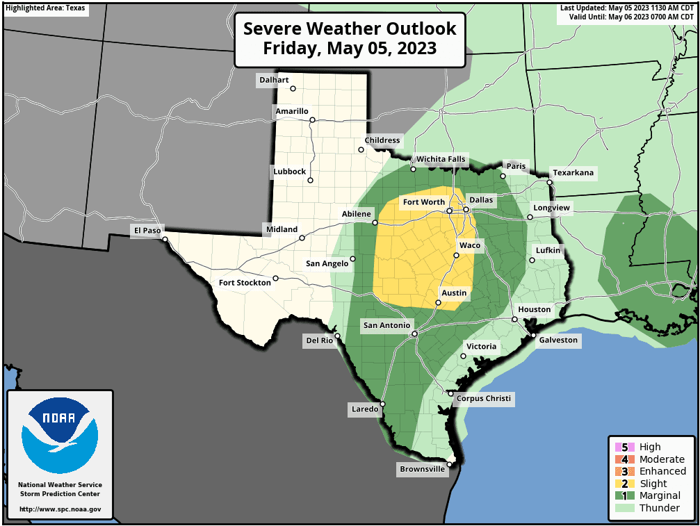
For areas that do see thunderstorms, there is a potential for the storms to be strong to severe. The Storm Prediction Center has placed much of the eastern Hill Country and the northern counties of Central Texas, including Austin, under a 2 out of 5 risk for severe thunderstorms through Friday night. The remainder of the region, extending southeast to around Columbus has been placed under a 1 out 5 risk for severe thunderstorms. Primary severe weather threats will be large hail, followed by damaging downburst winds. The tornado threat is very low. For areas that do see rain and storms, totals are forecast to average around a quarter inch, with isolated totals to near 1 inch possible.
The majority of the thunderstorm activity is forecast to diminish by about midnight Friday night.
High temperatures Friday are forecast to be around 90-92 degrees, with some mid-90s possible across parts of the Hill Country.
Sunday through Tuesday
Similar weather is forecast Saturday through Tuesday. The primary focus for thunderstorm development during this period will be the west Texas dry line. Thunderstorms are predicted to develop each afternoon across West Texas, the Edwards Plateau, and northeastern Mexico. Developing storms will have the potential to track northeast across the Hill Country and parts of Central Texas during the late afternoon and evenings. The probability for thunderstorms each day will be near 20-30 percent. No rain is forecast across the coastal plains region.
Some of the thunderstorms may be severe and have the potential to produce very large hail.
Daily rain amounts are forecast to only average around a quarter inch. Isolated heavier totals will be possible.
With a partly cloudy sky, daily high temperatures look to continue around 90-92 degrees. Low temperatures will be in the upper 60s to mid-70s.
Wednesday through Friday
Forecasts are pointing toward an increased chance for scattered rain showers and thunderstorms across the entire region as a large trough of low pressure settles into the Desert Southwest. More frequent periods of rain can be expected. Forecasts call for widespread daily rain amounts of 0.25 to 0.5 inches.
Expect a mostly cloudy sky each day, with high temperatures a little lower in the mid to upper 80s.
Next Weekend
The chance for rain looks to decrease, with just a slight chance for rain expected both days. High temperatures are forecast to continue in the mid to upper 80s.
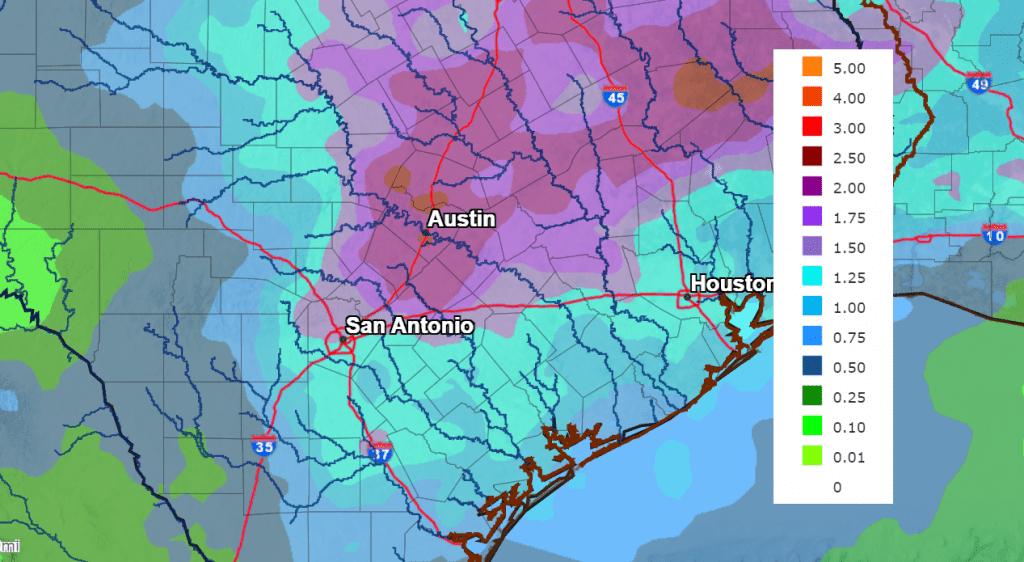
Rainfall Over the Next Seven Days
The National Weather Service’s 7-day rainfall forecast calls for widespread totals of 1-2 inches across the eastern Hill Country and Central Texas. Elsewhere, most totals should average around 1-1.5 inches.
NWS Rainfall Forecast for the Period 7 pm Friday through 7 pm Next Friday:
Have a good weekend!
Bob
Social Media