Excessive Heat to Continue this Week. Eyeing a Small Chance for Rain in Another Week
July 17, 2023
The heatwave persisted over the weekend, with more widespread triple-digit temperatures across the entire region. Over the past week, the temperature has averaged between 6 and 8 degrees above normal across the Hill Country and Central Texas regions, and between 4 and 6 degrees above normal across the coastal plains! As of Monday, Austin has recorded 9 consecutive days with the temperature at or above 100 degrees, and 7 consecutive days with the temperature at or above 105 degrees! Unfortunately, the heatwave is far from backing down. Some of the hottest temperatures of the heatwave are forecast to occur today through Wednesday, before a slight moderation occurs late week and through the weekend.
Monday’s weather maps showed an unusually strong ridge of high pressure, or heat dome, covering the western U.S., extending southeast to Texas and Louisiana. The ridge is currently centered over eastern Arizona and western New Mexico. Sinking air associated with the ridge will keep weather conditions sunny and very hot all week! Forecasts call for the center of the ridge to shift east to eastern New Mexico and the Texas Panhandle Region Tuesday and Wednesday, then shift back west to the Four Corners region Thursday and Friday. With the ridge center moving closer to our region, high temperatures are predicted to rise a degree or two from weekend readings today through Wednesday.
- High temperatures Monday through Wednesday are forecast to be between 103 and 108 degrees across the Hill Country and Central Texas regions, and be between 98 and 102 degrees across the coastal plains.
With the ridge center shifting further to the west late week and into the weekend, high temperatures are forecast to moderate down about 2-3 degrees.
- High temperatures Thursday through Saturday are forecast to be between 102 and 105 degrees across the Hill Country and Central Texas regions, and be between 98 and 101 degrees across the coastal plains.
Additional changes to the weather pattern are forecast to take shape beginning Sunday when the ridge shifts further to the northwest and a broad trough of low pressure builds south from the Great Lakes to the Lower Mississippi Valley. A northwesterly wind flow between the western ridge and eastern trough is forecast to develop across Texas beginning Sunday. Between Sunday and next Wednesday, occasional atmospheric disturbances are forecast to track southeast into North Texas along this northwesterly wind flow. These disturbances will have the potential to spark areas of rain and thunderstorms that may flow southeast into parts of the Hill Country, Central Texas, and the coastal plains. As of now, the probability for rain each day will be around 20-30 percent. Total rain amounts through Wednesday are forecast to only average around a quarter inch, with a few isolated heavier totals.
- High temperatures Sunday through next Wednesday are forecast to be near 101-103 degrees across the Hill Country and Central Texas regions, and in the upper 90s across the coastal plains.
Beginning next Thursday, the trough of low pressure over the Mississippi Valley is forecast to shift more to the east, allowing the western ridge to spread back across Texas. This will cause the sunny and hot weather pattern to resume across the area. Forecasts do call for the center of the ridge to remain across the Four Corners region through the end of the month.
High temperatures late next week into the following weekend are forecast to remain around 101-104 degrees.
There are unfortunately no signs of any significant changes to the hot weather pattern heading into early August.
Tropical Weather Outlook
Weather conditions across the tropical Atlantic, the Caribbean Sea, and the Gulf of Mexico remain quiet. There are no systems in place which pose a threat for tropical development over the next seven days.
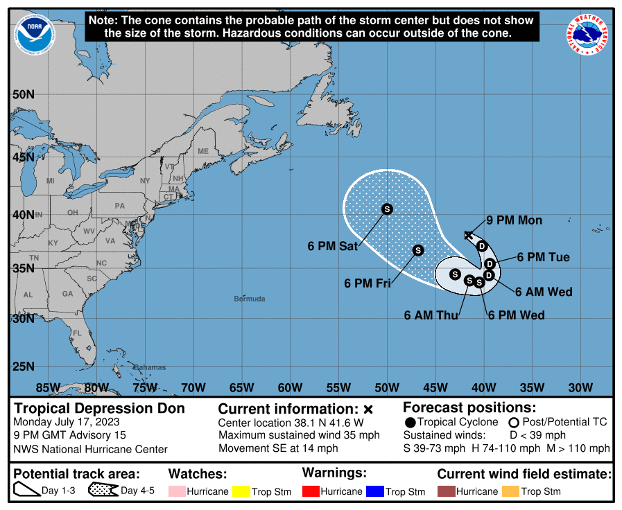
Out across the north central Atlantic, Tropical Depression Don is in the midst of a large track loop, not affecting any land areas. As of 10 am CDT, the center of Tropical Depression Don was located about 860 miles west of the Azores. The depression was moving toward the east-southeast near 14 mph. The depression should turn southward on Tuesday, westward on Wednesday and west-northwestward on Thursday over the open waters of the central Atlantic. Maximum sustained winds remain near 35 mph with higher gusts. Don could become a tropical storm by midweek with additional strengthening possible by late week.
Saharan Dust Update
From the Texas Commission on Environmental Quality:
The plume of African dust currently over Texas is forecast to begin weakening and dissipating today through Wednesday, with model guidance indicating the highest density concentrations to be primarily east and south of a line from Eagle Pass to Nacogdoches. Meanwhile, models indicate that very light residual smoke associated with the Canadian wildfires could continue to linger over a good majority of the state in very low concentrations.
Another plume of Saharan dust is forecast to spread into the eastern half of Texas beginning Thursday.
Have a good week.
Bob
Social Media