Heavy Rain, Severe Storms, and a Risk for Flooding Friday Night and through the Weekend
May 11, 2023
Highlights:
- Periods of heavy rainfall and potential flash flooding continue to appear likely from Friday night through Sunday, possibly continuing into early next week.
- Severe thunderstorms will be possible over portions of the area on Friday night and Saturday Night, with large hail and damaging winds being the primary concerns.
- Now is the time to plan for possible high-impact flash flooding this holiday weekend.
Discussion and Outlook
A period of very wet weather is still on track to develop late Friday, continuing through the weekend and even into Monday. This wet pattern is being driven by a large trough of low pressure that will be sinking south into northern Mexico Friday, then holding essentially stationary into early next week. Forecasts call for a series of small waves of low pressure to rotate through the trough over the next few days, with each of these waves initiating areas of rain and thunderstorms, with the potential for some periods of moderate to heavy rain.
This afternoon, the National Weather Service posted a Flood Watch for the Hill Country and all of Central Texas, going into effect Friday evening, continuing through Saturday evening. Runoff from heavy rain late Friday through Saturday may result in the flooding of creeks, streams, and other low-lying and flood prone locations. Extensive street flooding will also be possible.
Our region is currently between storm systems. As a result, no rain is forecast Thursday afternoon through midday Friday.
A large area of thunderstorms is forecast to develop across the Rio Grande Plains ahead of the first wave of low pressure late Friday afternoon/Friday evening. This area of thunderstorms is predicted grow into a very large complex of rain and thunderstorms that will spread northeast across the Edwards Plateau and Hill Country regions Friday night, reaching Central Texas sometime late Friday night into early Saturday morning and the middle Texas coast late Saturday morning. The large complex of rain and thunderstorms is predicted to be very slow-moving and is expected to persist across the area through a good part of Saturday. Additional waves of rain showers and thunderstorms are forecast Saturday night through Monday.
Forecasts call for the highest totals of rain this weekend to occur across the Hill Country. Slightly lower totals are forecast across the Austin/Central Texas area and the middle Texas coast. Between Friday evening and Saturday evening, general totals of 1-3 inches are forecast across the Hill Country, totals of 1-2 inches across Central Texas, with totals under a half inch along the middle Texas coast. Isolated heavier totals will be possible. Saturday evening through Sunday evening, additional totals of 1-2 inches are forecast across the entire region. Monday is forecast to bring another 1-2 inches of rain to most of the region. Additional waves of rain are forecast to continue Tuesday through Thursday, with daily totals expected to be around a half inch.

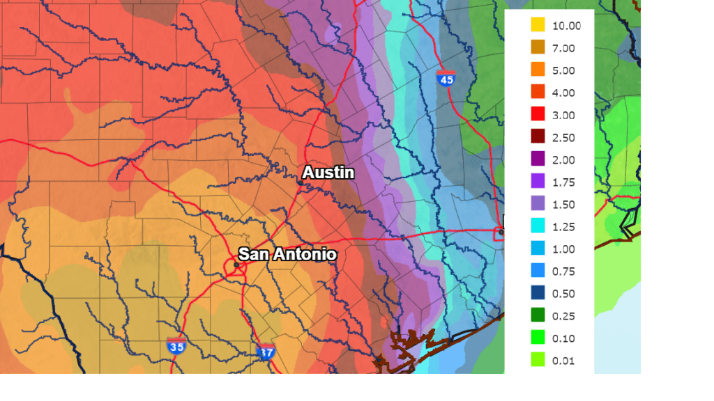
Cumulative totals over the next five days are forecast to be in the general range of 5 to 8 inches across the Hill Country, 3 to 5 inches across Central Texas, and 1 to 3 inches along the middle Texas coast. Isolated pockets of higher totals will also be possible.
NWS Rainfall Forecast for the Period 7 pm Thursday through 7 pm Tuesday:
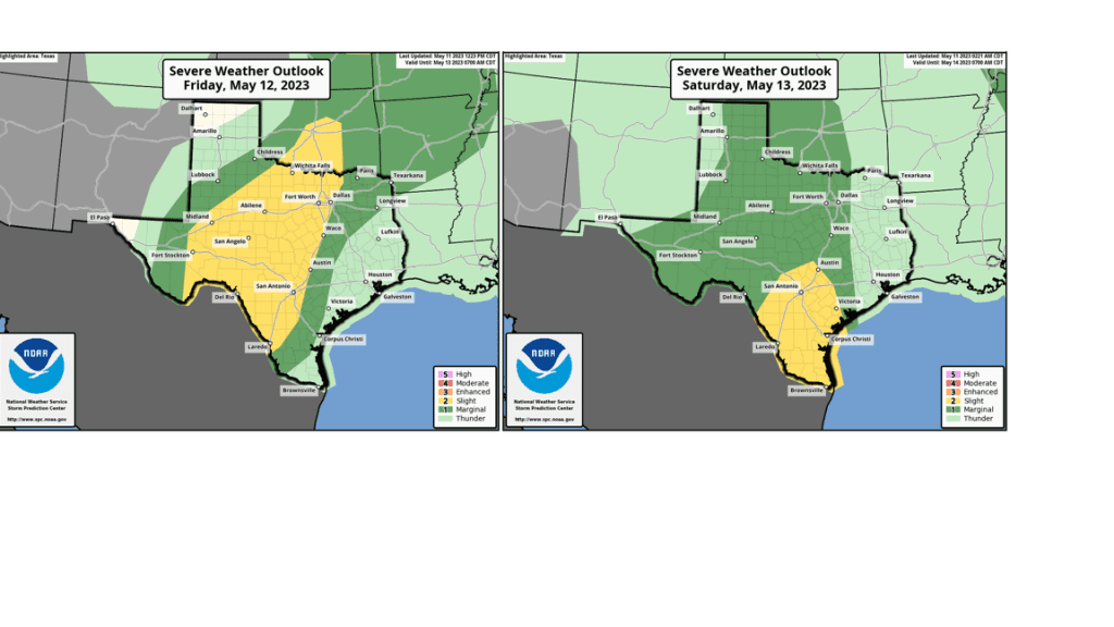
Some of these thunderstorms Friday night into Saturday may be strong to severe. The Storm Prediction Center has placed all of the Hill Country under a 2 out of 5 risk for severe thunderstorms Friday night through 7 am Saturday. The area between Austin and La Grange has been placed under a 1 out of 5 risk for the same time period. The primary severe weather risks will be damaging downburst winds and large hail, but an isolated tornado or two cannot be ruled out. A slightly lower risk for severe thunderstorms will continue Saturday night through Sunday as well.
As mentioned earlier, a chance for rain is forecast to continue through at least next Thursday. This is shaping up to be a very wet pattern. Stay weather aware are remember: Turn Around, Don’t Drown.
With the forecast for heavy rain across the Hill Country this weekend, the risk for flooding has increased around the Highland Lakes. Sign up to receive a text, email or phone call from the LCRA Flood Operations Notification Service (LCRA FONS) any time flood operations begin on the Highland Lakes.
Bob
Social Media