Heavy Rain, Strong Storms, and Possible Flooding through the Weekend
May 12, 2023
Here’s an update to the wet weather pattern that is set to unfold across the region.
Key points:
- Rain showers and strong to possibly severe thunderstorms are forecast to spread into the Hill Country out of Mexico beginning late Friday evening, with the activity spreading into the Hill Country and Central Texas during the overnight hours.
- Additional rounds of storms with moderate to heavy rain are forecast Saturday through early next week.
- A Flood Watch has been posted for all of the region beginning this evening and continuing through Saturday. The watch will likely be extended beyond Saturday.
- 3 to 6 inches of rain can be expected over much of the area through early next week, with some isolated totals of up to 10 inches possible.
- Be sure to have multiple ways to receive flood and severe weather-related warnings.
Discussion and Outlook
There have been no significant changes in the weather outlook for this weekend and early next week. Rounds of showers and thunderstorms are forecast over the weekend, continuing into Monday. The atmosphere is predicted to be favorable for producing periods of moderate to heavy rain. In addition, some of the storms Friday night and through the weekend may produce large hail and damaging winds.
Friday morning’s high-resolution forecast data calls for an extensive area of thunderstorms to develop across northeastern Mexico and Far West Texas early this evening. The thunderstorms are forecast to spread east across the Concho Valley and the Edwards Plateau this evening, moving across the Hill Country between about midnight and 3 am. The thunderstorms are forecast to move across the Austin and Central Texas region between about 2 am and 6 am, and the middle Texas coast after daybreak Saturday. Some of these thunderstorms may be strong to severe, capable of producing large hail and damaging downburst winds of 40-70 mph. Behind the initial line of thunderstorms, additional rain and scattered thunderstorms are forecast to continue Friday night through Saturday morning.
Some occasional breaks from the rain and thunderstorms do look to develop Saturday afternoon, but additional rounds of rain showers and thunderstorms are forecast to continue Saturday night, Sunday, and Monday. Thanks to a very moist flow off the Gulf of Mexico, some this rain will at times be heavy, increasing the threat for flooding.
Because of the increased threat for flooding, the National Weather Service has posted a Flood Watch for the entire region through Saturday evening. NWS forecasters do intend to extend the watch through Sunday and possibly Monday.
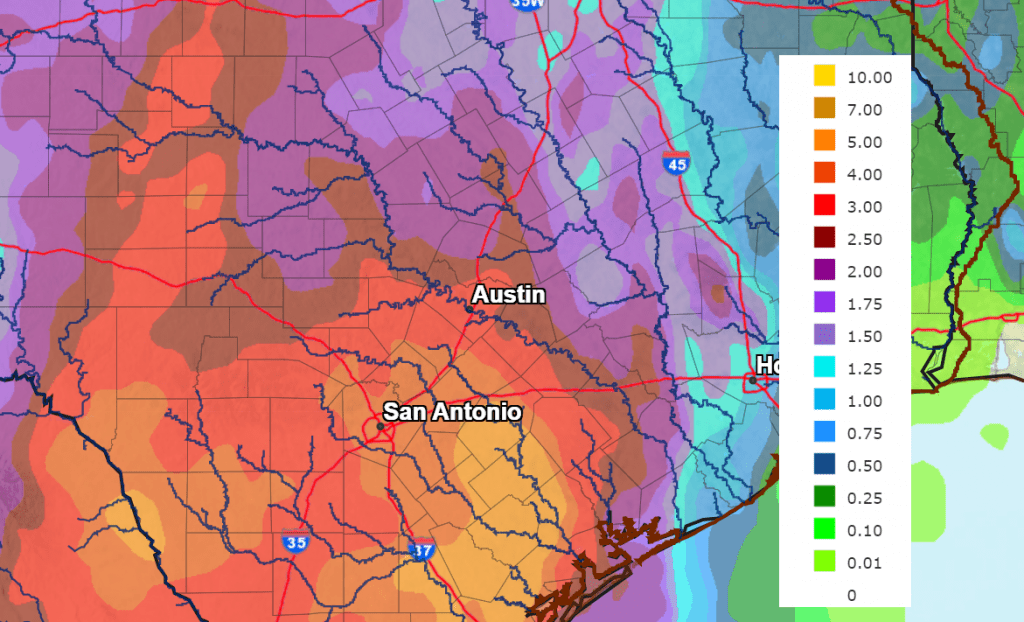
Forecasted rain amounts through Tuesday have not changed very much. Forecasts call for widespread totals of 3-6 inches for the Hill Country and the Austin/Interstate 35 corridor. For areas east of Interstate 35, totals through Tuesday are forecast to range from 3-4 inches in the Bastrop/La Grange area, to around 1-3 inches for areas south of Interstate 10.
NWS Rainfall Forecast for the Period 7 pm Friday through 7 pm Monday:
Scattered rain showers and thunderstorms are forecast to continue Tuesday through next Friday due to lingering Gulf moisture and a slightly unstable atmosphere. The probability for rain each day will be near 30-40 percent. Forecasts call for daily rain amounts to be in the range of 0.25-0.5 inches, with some locally heavy downpours still possible.
Be very weather aware this weekend! Heavy rain can lead to flash flooding. This can be especially dangerous at night when it is more difficult to recognize flooding. Stay tuned to trusted news sources and be ready to seek higher ground.
With the forecast for heavy rain across the Hill Country this weekend, the risk for flooding has increased around the Highland Lakes. Sign up to receive a text, email or phone call from the LCRA Flood Operations Notification Service (LCRA FONS) any time flood operations begin on the Highland Lakes.
Bob
Social Media