Much Cooler this Weekend. Trending Mild Again Next Week
March 8, 2024
A line of rain showers and thunderstorms spread east across the Hill Country and the Interstate 35 corridor late Thursday night into early Friday morning. Several of the storms produced small hail and gusty winds with speeds up to 40 mph. Rain from the line of storms varied between just a few hundredths to nearly three quarters of an inch. LCRA’s highest gauged total was 1.17 inches at a gauge located out in the western Hill County, just south of Sonora. The line of storms weakened considerably as they moved past the I-35 corridor. LCRA’s Hydromet showed totals between Bastrop and Bay City averaging just a few hundredths of an inch. A slight chance for scattered rain showers will continue for the area south of Interstate 10 through early Friday afternoon, but no significant rain is forecast.
- Friday morning’s rain ended a near month-long dry spell across the region. The last significant rain for most areas was on February 10th.
Dry and mild air will spread across the region Friday afternoon in the wake of Thursday night’s storms. It will be a warm day, with temperatures in the 70s to the low 80s. Expect a northwesterly wind at 10-15 mph.
Much cooler air is poised to spread south across our area Friday evening and Friday night. A Canadian cold front currently situated across Northwest Texas is forecast to push southeast, reaching the northern Hill Country around sunset, the Austin and Central Texas area Friday evening, and the coastal area by midnight. No rain is forecast along the front. Breezy to windy conditions look to develop Friday evening and continue Friday night. Expect northerly winds at 10-20 mph and gusts to 35 mph. Noticeably cooler conditions will develop Friday evening and Friday night.
- Lows Saturday morning are forecast to be near 38-42 degrees across the Hill Country, in the mid-40s across Central Texas, and around 50 degrees across the coastal area.
A much chillier weekend is store for the region in the wake of Friday’s cold front. A partly cloudy to mostly sunny sky is forecast Saturday through Sunday. However, breezy north winds with gusts to 35 mph will continue through Saturday afternoon, making it feel quite chilly. Wind speeds should decrease to 10-15 mph Saturday evening and 5-10 mph on Sunday.
- High temperatures Saturday and Sunday are predicted to be in the low 60s.
- Lows Sunday morning will include the mid and upper 30s across the Hill Country, the low 40s across Central Texas, and mid-40s across the coastal plains.
- Lows Monday morning are forecast to be near 40 degrees across the Hill Country, the low 40s across Central Texas, with mid-40s towards the coast.
Mostly sunny and warmer weather is predicted for the first half of next week as southerly breezes return. High temperatures are forecast to be in the low 70s Monday, the mid-70s, Tuesday, and the low 80s Wednesday. Lows Tuesday through Thursday mornings look to be in the 50s to low 60s.
Forecasts point to the development of a wet and unsettled weather pattern late next week as a strong trough of low pressure approaches our region from northern Mexico. The forecast solutions call for an area of showers and thunderstorms to push east out of West Texas Thursday afternoon and Thursday night. There are early indications some of these storms may be strong to severe. Additional rain is forecast Friday and possibly into next Saturday when a Canadian cold front sinks south through our area. There is still much model uncertainty on the timing and movement of the low pressure trough.
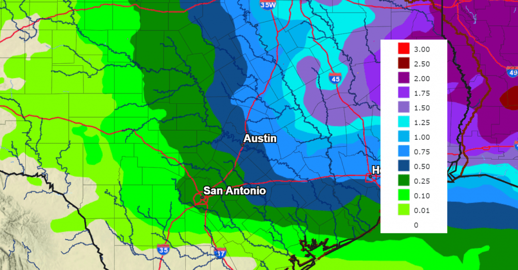
An early look at potential rainfall for late next week calls for the highest totals to occur across the eastern half of Texas, with lower amounts out to the west. This forecast will likely change over the next few days as the forecast models get a better handle on the developing weather situation.
NWS Rainfall Forecast for the Period 7 pm Wednesday through 7 pm Friday:
Slightly cooler weather looks to follow next weekend, with highs in the 60s to low 70s, and lows in the 40s to low 50s.
Time Change Weekend
A Reminder Daylight Saving Time will begin this Sunday, March 10th at 2 am local time. At that time, our clocks will need to “spring forward” one hour. Sunrise and sunset will be about 1 hour later on Mar 10, 2024 than the day before.
Have a great weekend!
Bob
Social Media