Periods of Rain and Thunderstorms Expected Thursday through Sunday
March 12, 2024
The recent development of southerly winds off the Gulf has brought the return of warm and more humid weather. Weather conditions will be mostly sunny, breezy, and warm Tuesday afternoon. High temperatures are forecast to generally be in the mid and upper 70s. Expect a southerly breeze at 10-15 mph.
The sky is forecast to become cloudy Tuesday evening and Tuesday night as low-level moisture increases off the Gulf. Some patchy drizzle will be possible after midnight Tuesday night, continuing through late Wednesday morning. Lows Wednesday morning are forecast to be in the low and mid-60s. The clouds should burn off around midday, with the sky becoming partly cloudy Wednesday afternoon. Wednesday will likely be the warmest day of the week, with the temperature reaching the low and mid-80s. A southerly breeze at 10-15 mph looks to continue.
Cloudy, breezy, and warm weather will continue Wednesday night. Lows Thursday morning are forecast to be in the mid and upper 60s.
A cloudy, unsettled, and potentially stormy weather pattern is forecast to take shape across our region Thursday into Thursday evening as a trough of low pressure in the upper atmosphere over the northern Rockies sinks south into the Southwestern U.S., then stalling over the area through the weekend. Winds flowing around the trough are expected to pull smaller waves of low pressure across Mexico and Texas beginning Thursday and continuing through weekend.
Thursday is shaping up to be the primary day of concern for potentially strong to severe thunderstorms as the first of the small waves of low pressure is forecast to move across Texas. The atmosphere over the central and eastern half of the state is forecast to become increasingly unstable ahead of the approaching trough. At the same time, the dry line is forecast to push east out of West Texas Thursday afternoon. Forecast solutions do indicate a stable layer, or cap, in the lower atmosphere will help to limit the develop of widespread thunderstorms across the western and central Hill Country. However, the forecast solutions call for the cap to weaken across the eastern Hill Country and the northern half of Central Texas, including the Austin metro, Thursday afternoon into Thursday evening. This will allow for the development of scattered thunderstorms, with some of the thunderstorms possibly becoming strong to severe. The primary severe threat will be large hail, followed by damaging downburst winds.
The Storm Prediction Center has placed the area from just north of Austin, north to Waco and the DFW metroplex under Slight Risk, or 2 out of 5 risk, for severe thunderstorms through Thursday evening. A Marginal Risk (a 1 out of 5 risk) extends across the area from San Saba, to Llano, Austin, and Giddings. Across the rest of the region, the threat for severe storms appears low.
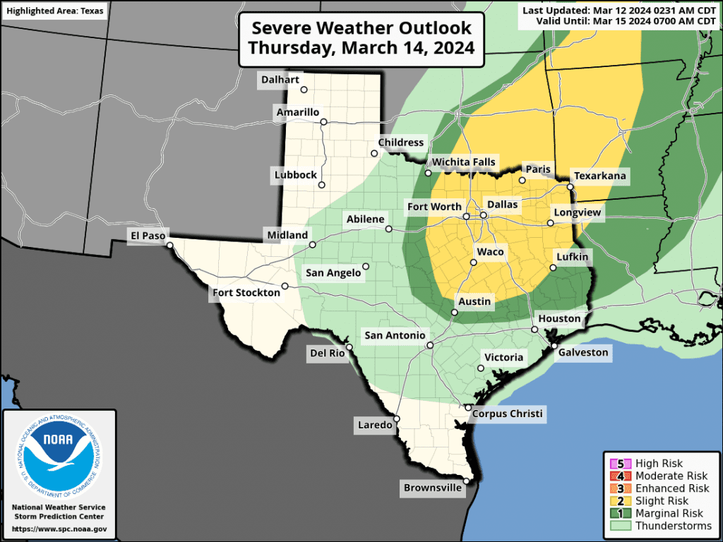
For Thursday afternoon through Thursday evening, the probability for scattered rain and thunderstorms for the western and central Hill Country is forecast to be near 30 percent. For the eastern Hill Country and the Austin/Central Texas area the probability for rain and storms is forecast to be near 50 percent. The probability for rain across the coastal plains is forecast to be near 20 percent.
Periods of rain showers and scattered thunderstorms are forecast for the entire region between Thursday night and Sunday afternoon as additional waves of low pressure continue to move over the area out of Mexico. The threat for severe storms during this time will be low. The probability for rain will be near 50-60 percent. Expect a mostly cloudy sky Friday through Sunday. A weak cold front is forecast to push south across the Friday, bringing slightly cooler air for the weekend.
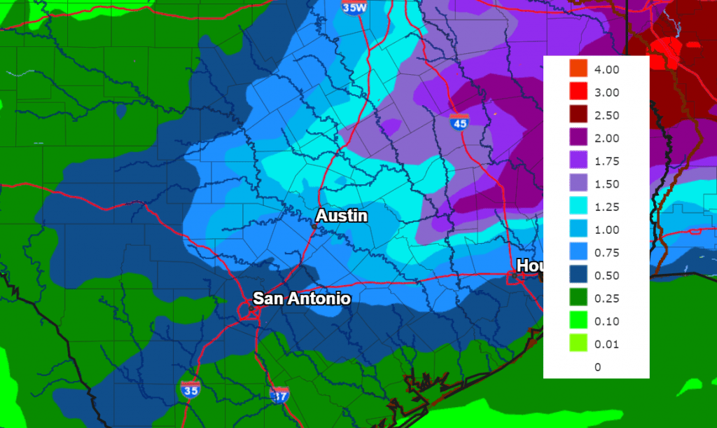
Daily rain amounts between Thursday and Sunday are forecast to generally average between a quarter and a half inch. Some isolated heavier downpours will be possible—especially for locations located along and east of I-35. Rain amounts through Sunday are forecast to total between 0.5 and 1 inch across the western and central Hill Country, between 1 and 1.5 inches across Central Texas, and between 0.5 and 1 inch across the middle Texas coast.
NWS Total Rain Forecast, Valid through 7 pm Sunday:
Weekend temperatures are forecast to rend a little cooler behind the cold front with highs in the mid and upper 60s. Lows are predicted to be in the 40s across the Hill Country, the 50s across Central Texas, with low 60s near the coast.
For next week, weather conditions are shaping up to be partly cloudy, dry, and mild Monday through Wednesday. A chance for rain showers is forecast next Thursday into Friday as a trough of low pressure dips south out of the southern Plains. A cold front Monday is expected to bring a push of slightly cooler air that remain in place through Wednesday.
High temperatures Monday through Wednesday are forecast to generally be in the mid-60s. Lows will include the low 40s across the Hill Country, the mid-40s across Central Texas, and the low 50s across the coastal plains. Warmer temperatures will return for next Thursday and Friday.
Bob
Social Media