Pleasant Weekend Weather. A Chance for Rain and Storms Returning Late Sunday Night
March 22, 2024
Waves of low pressure moving across Texas Wednesday through Thursday brought periods of rain and thunderstorms to our area. The heaviest rain by far occurred across the coastal plains, between La Grange and Bay City, where totals of 1-3 inches were recorded. The Wharton area was the big winner, with a 2-day total of just over 3 inches. Across the rest of the region, totals generally ranged between a quarter and a half inch, with a couple of isolated totals near 1 inch. Unfortunately, with the way the rain took shape, the western half of the Hill Country received little to no rain.
Dry and mild air is spreading into Texas in the wake of Thursday’s rain and storms. Sunny and breezy weather will be in place Friday afternoon. Expect a northwesterly breeze at 10-15 mph, with occasional gusts to 25 mph. Afternoon temperatures are forecast to climb into the mid and upper 70s.
A reinforcing shot of dry and just slightly cooler air is predicted to spread south across the area Friday night into Saturday morning. The weekend weather is shaping up to be dry and mild as a weak ridge of high pressure slides over Texas out of Mexico. Light winds are forecast Saturday, but windy conditions look to develop Sunday into Sunday night as a deep area of low pressure develops across the southern Rockies. Sunday’s wind is predicted to be in the range of 20-25 mph, with gusts as high as 40/45 mph.
- High temperatures Saturday and Sunday are forecast to be in the mid-70s.
- Lows Sunday morning will generally be in the mid-50s.
- Lows Monday morning will range from the mid-50s west, to the mid-60s near the coast.
A chance for rain showers and scattered thunderstorms is forecast to develop across the Hill Country and Central Texas regions after midnight Sunday night when a Pacific cold front pushes southeast out of Northwest Texas. Forecasts call for an area of showers and scattered thunderstorms to develop ahead of and along the front as it slowly tracks to the southeast. The area of rain is predicted to exit the Hill Country just after sunrise Monday, Central Texas around mid-morning, and the coastal region by midday. The probability for rain at any given location will be around 50-60 percent. As of now, it appears the best zone for severe storms with the cold front will be over East and Northeast Texas. An isolated strong to severe thunderstorm will be possible across our region, but widespread severe storms are not anticipated.
Rain amounts between Sunday night and midday Monday are not forecast to be very heavy, with most totals averaging less than a half inch.
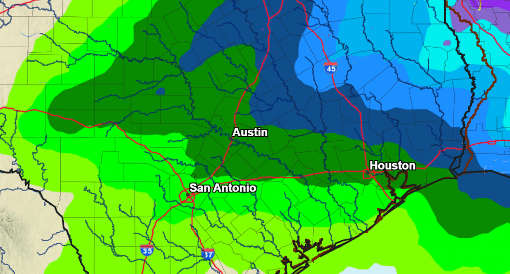
NWS Rainfall Forecast for the Period 7 pm Friday through 7 pm Wednesday:
The sky is forecast to become partly cloudy Monday afternoon. Expect a high temperatures in the low 70s.
Forecasts call for a second, brief window for scattered rain showers and isolated thunderstorms to take shape after midnight Monday night, continuing till around daybreak Tuesday when a wave of low pressure swings east across North Texas. The probability for rain will only be near 20-30 percent. Rain amounts, if any, should total less than a quarter inch.
Sunshine and cooler temperatures are forecast Tuesday through Wednesday in the wake of a Canadian cold front that looks to push south across the area early Tuesday morning.
- Lows Tuesday morning will range from mid-40s across the Hill Country, to the mid-50s towards the coast.
- High temperatures Tuesday are forecast to be in the upper 60s.
- Lows Wednesday and Thursday mornings are forecast to be in the mid and upper 40s.
- High temperatures Wednesday are predicted to be in the low 70s.
Sunny and mild weather is forecast late next week, continuing into next weekend. High temperatures are predicted to be in the upper 70s late week, warming to the low 80s over the weekend. Lows will be mostly in the 50s. Mild temperatures are expected to continue through the week of April 1st.
The next opportunity for rain is forecast to take shape around April 1st and 2nd, when a large trough of low pressure sets up across the western U.S.
Watch for the Planet Mercury this Weekend and Next Week
The elusive planet Mercury will be quite visible this weekend and over the next few days, but don’t delay. Mercury will be visible low in the western evening twilight, about 45 to 60 minutes after sunset. Look for it almost due west, about two fists at arm’s length below or lower right of the bright planet Jupiter. Watch Mercury fade rapidly next week from a prominent magnitude –0.4 Monday, to a bashful +1.0 late week (a loss of nearly three quarters of its light) even as it remains at about the same height.
Have a great weekend!
Bob
Social Media