Scattered Showers and Thunderstorms Expected Memorial Day and Tuesday
May 26, 2023
Memorial Day weekends have had a history of producing big rains and notable floods across Central Texas. This year, flooding rains are not in the forecast. However, there will be a 30-40 percent chance for scattered rain showers and thunderstorms across the area late Sunday through Memorial Day and also on Tuesday. Rain amounts Monday are forecast to generally average between 0.25 and 0.5 inches, with isolated totals of 1-2 inches possible. Totals on Tuesday should average around a quarter inch.
Weekend high temperatures are forecast to be mostly in the mid and upper 80s.
The outlook for the remainder of next week calls for dry weather to take hold Wednesday and Thursday before a wet and unsettled pattern returns for Friday and next weekend. High temperatures next week are forecast to continue near 88-90 degrees.
Here’s a breakdown of the weekend and next week’s weather:
This Afternoon through Friday Night
As of late Friday morning, a complex of rain showers and thunderstorms was located across Northwest Texas, between Big Spring and Childress, moving to the east-southeast. This system is expected to hold together through mid-afternoon and has the potential to bring some rain to the area between Abilene, Coleman, and Brownwood. Rain amounts should average between 0.25 and 0.5 inches.
For the rest of the region, mostly sunny and dry weather is forecast this afternoon. Expect high temperatures generally in the upper 80s.
Expect a clear to partly cloudy sky Friday night. Lows Saturday morning will be in the mid and upper 60s.
Saturday through Saturday Night
Mostly sunny and warm weather is forecast across the region Saturday. High temperatures are forecast to be in the upper 80s.
Forecasts call for scattered thunderstorms to develop across the Rio Grande Plains late Saturday afternoon. These storms will move to the east and there’s a slight chance a few of these storms could reach the Edwards Plateau/western Hill Country region late Saturday evening before dissipating.
The weather should remain dry across the rest of the area Saturday night. Lows Sunday morning will be in the upper 60s.
Sunday through Sunday Night
A mostly sunny to partly cloudy sky will continue across the region on Sunday. However, there will be a slight chance for some scattered thunderstorms to develop across the Hill County region Sunday afternoon, continuing through Sunday evening. This will be in advance of a trough of low pressure pushing east out of northern Mexico. The probability for rain will be near 20-30 percent. There will also a slight chance for a few scattered thunderstorms across the Interstate 35 corridor Sunday evening. Rain amounts, if any, should total less than a quarter inch.
High temperatures Sunday are forecast to be in the mid and upper 80s.
Memorial Day and Monday Night
The trough of low pressure is forecast to move over the region Monday, causing a 40-50 chance for scattered rain showers and thunderstorms Monday afternoon, and a 20-30 percent chance for scattered rain showers and thunderstorms Monday evening and Monday night. This won’t be an all-afternoon type rain, but do be prepared for periods of rain and thunderstorms.
Rain amounts Monday through Monday night are forecast to total between 0.25 and 0.5 inches, with isolated totals of 1-2 inches possible.
Expect a mostly cloudy sky throughout the day, with high temperatures in the mid and upper 80s.
Tuesday and Tuesday Night
There will be a 40-50 percent chance for scattered rain showers and thunderstorms for the area along and east of Interstate 35 as the trough of low pressure slowly moves off to the east. For the Hill Country, expect just a 20 percent chance for additional showers and thunderstorms. The chance for rain should diminish across the entire region by Tuesday evening as the trough exits our region.
Rain amounts Tuesday are forecast to average between a quarter inch and a half inch for areas along and east of I-35. Isolated totals to near 1 inch will be possible—mainly across the coastal plains. For the Hill Country, totals should average less than a quarter inch.
High temperatures Tuesday are forecast to be in the mid and upper 80s.
Next Wednesday through Thursday
Mostly sunny and dry weather is forecast as a weak ridge of high pressure sets up across the state. High temperatures are forecast to be near 88-90 degrees.
Friday into Next Weekend
An unsettled weather pattern is forecast to develop as a large trough of low pressure moves into the Desert Southwest, pulling considerable Gulf moisture into the area. Forecasts point to an increasing chance for scattered rain showers and thunderstorms across the region, with some locally heavy rain possible. Expect high temperatures in the upper 80s.
Tropical Weather Update
National Hurricane Center forecasters are closely monitoring a broad non-tropical area of low pressure located east of the northeastern coast of Florida. This system and a frontal boundary located off the coast of the Southeastern U.S. are producing a large area of disorganized showers and thunderstorms. Forecasters believe the low is unlikely to become a subtropical or tropical cyclone since it is forecast to remain frontal while moving generally northward and inland over the Carolinas late Saturday or Sunday. The probability for tropical development over the next 48 hours is only 10 percent. Regardless, the system is expected to produce gusty winds, and dangerous surf and rip current conditions along portions of the Southeastern U.S. coast through Sunday. Heavy rainfall is expected over portions of the Carolinas and Virginia during the next few days.
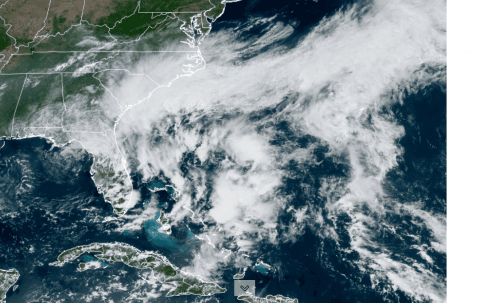
2:20 pm CDT 05/26/2023 NOAA/RAMMB/Colorado State University
Weather conditions are quiet across the Gulf of Mexico, the Caribbean Sea and the tropical Atlantic. Tropical cyclone development is not expected over the next 7 days.
Wishing everyone a safe holiday weekend.
Bob
Social Media