Severe Storms Possible Friday and Saturday. Periods of Rain Forecast through Sunday
March 15, 2024
Strong to severe thunderstorms developed across the Concho Valley and western Hill Country early Friday. These storms tracked to the east-northeast, dropping large hail across parts of McCulloch and San Saba Counties. The storms also produced a swath of 0.5 to 1 inch totals of rain over the area between Sonora and Brownwood. Other area of showers and scattered thunderstorms spread east across Central Texas around sunrise. Totals here were generally less than a quarter inch. As of midday, all the morning shower and thunderstorms activity had pushed east of the Hill Country and Central Texas.
An active and unsettled weather pattern is forecast for the next two to three days as a weak cold front slowly sags south through the region and several waves of low pressure track northeast into Central Texas out of Mexico. With higher moisture levels now in place, conditions have become favorable for the development of pockets of moderate to heavy rain over the next couple of days.
A lull in the thunderstorm activity is forecast across the region through early afternoon. However, showers and scattered thunderstorms are forecast to redevelop across most of the area by about 2 or 3 pm as the atmosphere grows increasingly unstable. Due to the increased instability, some of the thunderstorms may become severe. The Storm Prediction Center has placed the area roughly along and south of U.S. Highway 290, including the Austin metro, under a Slight Risk (a 2 out of 5 risk) for severe thunderstorms through Friday night. Do note the area south of a line stretching from Kerrville to New Braunfels has been placed under an Enhanced Risk, or 3 out of 5 risk, for severe thunderstorms. Forecasts call for showers and thunderstorms to develop close to the position of the frontal boundary, then move to the east-northeast. The showers and thunderstorm activity is forecast to continue into Friday evening, diminishing sometime late Friday evening.
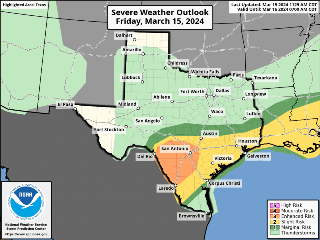
Today’s primary severe weather risk will be large to very large hail. (hail diameter in excess of baseball size). Damaging downburst winds will also be possible, particularly if thunderstorm clusters hold together. Some of today’s storms may also produce heavy rainfall which could lead to isolated flash flooding. Rain totals through daybreak Saturday are forecast to generally average around a half inch, with isolated totals of 1-2 inches possible.
Saturday through Saturday night is shaping up to be a cloudy and wet period across the region as the weak cold front stalls somewhere around Intestate 10. Waves of low pressure are forecast to lift northeast out of Mexico throughout the day, each causing periods of rain with scattered thunderstorms. There will be a low-end for threat some of Saturday’s storms to become severe across the Hill Country and the northern half of Central Texas. The Storm Prediction Center has placed the area south and southeast of Austin under a Slight Risk (or 2 out of 5 risk) for severe thunderstorms through Saturday night. The primary severe risk once again looks to large hail.
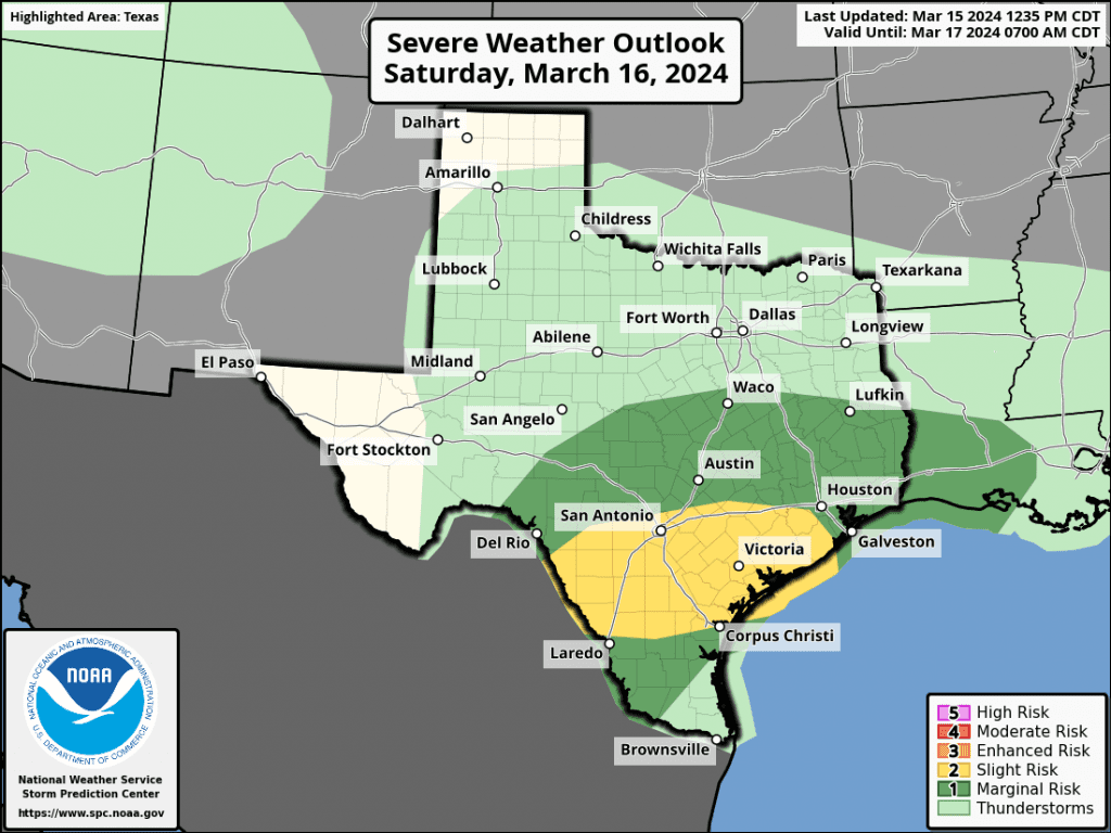
Forecast solutions call for the atmosphere on Saturday to be unusually moist, meaning moderate to heavy rain will be possible with the waves of rain. Rainfall forecasts for the period through daybreak Sunday call for widespread totals of 1-2 inches, with isolated heavier totals.
For Sunday, rain showers and scattered thunderstorms look to continue into early afternoon as additional waves of low pressure move over the region. The rain activity is expected to decrease in coverage across the area Sunday afternoon into Sunday evening as drier air spreads in from the north. The probability for rain will be near 60 percent Sunday morning, decreasing to 30 percent Sunday afternoon. Mostly cloudy and dry weather is forecast Sunday night. Rain amounts on Sunday are predicted to generally average around a quarter inch.
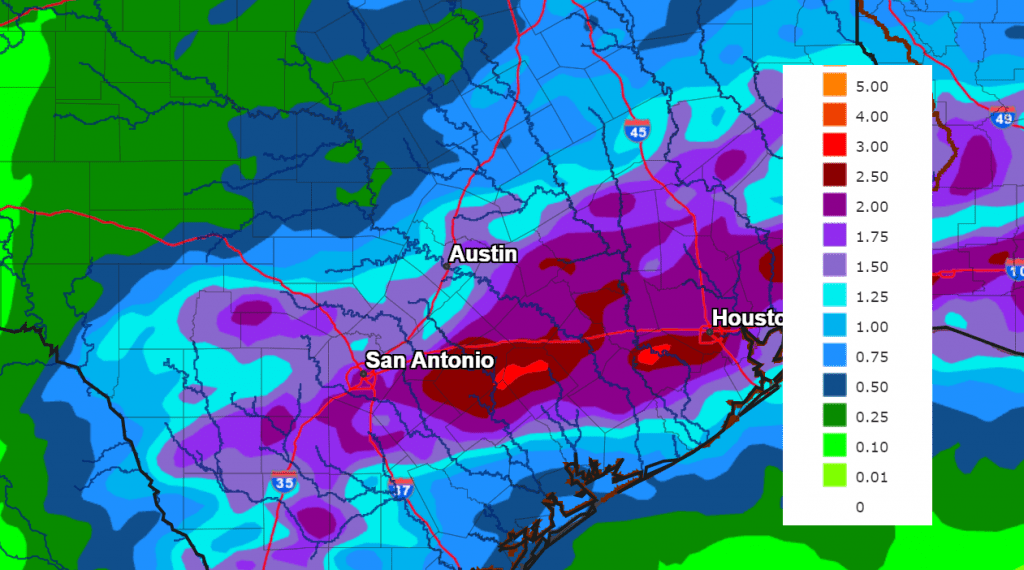
Cumulative rainfall totals from the National Weather Service for the period through daybreak Monday call are forecast to be between 1 and 1.5 inches across the Hill Country, and between 1 and 3 inches for most other locations.
NWS Rainfall Forecast for the Period 7 pm Friday through 7 pm Sunday:
The outlook for next week calls for mostly sunny and slightly cooler weather Monday and Tuesday, with highs in the 60s and lows in the 40s. A chance for showers and thunderstorms will return to the forecast Wednesday and Thursday. Rain amounts over the two days are forecast to average between a quarter and a half inch.
Bob
Social Media