Low Chances for Rain and Thunderstorms Expected throughout the Week
March 27, 2023
Weekend weather conditions were spring-like and fairly quiet. However, moisture returning off the Gulf of Mexico brought a few scattered showers to the parts of the coastal plains on Sunday. Rain amounts were mainly just a few hundredths of an inch, although there were a couple of totals close to 0.2 inches across Colorado County.
This week is going to offer up several chances for rain and thunderstorms, but no widespread or heavy rain is expected. Parts of the region will see a potential for some strong to severe thunderstorms Monday evening/Monday night and again around on Friday.
A small cooldown is forecast Tuesday into Wednesday. Otherwise, temperatures throughout the week are forecast to be mild and spring-like.
Monday Afternoon
A weak cold front pushed south across the area late Sunday night into early Monday, bringing slightly cooler air. As of midday Monday, the front had pulled up stationary along a line stretching from just east of Del Rio, southeast to the middle and upper Texas coast. The front is forecast to remain stationary Monday afternoon, then lift back to the north Monday afternoon into Monday evening. The boundary is predicted to be the focus for the development of scattered rain showers and thunderstorms this afternoon and tonight.
For this afternoon, there will be a slight chance for rain showers and thunderstorms across the Edwards Plateau, generally over the area between Ozona, Sonora, and Menard. There will also be a slight chance for scattered showers and isolated thunderstorms across the coastal plains region, to the south of Interstate 10. Rain amounts should average less than a quarter inch. Across the eastern Hill Country and Central Texas, no rain is expected.
Under a partly cloudy sky, Monday’s high temperature will range from the mid-70s across the Hill Country and Central Texas regions, to the low 80s near the coast.
Monday Evening and Monday Night
The chance for rain and thunderstorms is forecast to increase across the entire region beginning Monday evening as a weak trough of low pressure tracks northeast out of Mexico, enhancing atmospheric lift. Forecasts show the best chance for rain and thunderstorms to be across the Edwards Plateau, along with the western and northern Hill Country. There will also be an increased chance for rain and storms across the eastern half of Central Texas and all of Southeast Texas. Some of the thunderstorms may be strong to severe, with primary severe weather threat being large hail.
The probability for rain and storms Tuesday evening and Tuesday night will be near 40-50 percent.
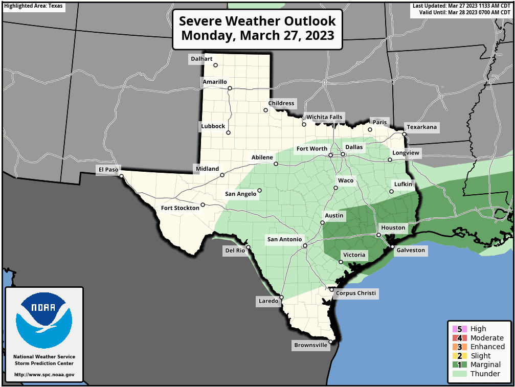
The Storm Prediction Center has placed the area generally to the east of Interstate 35 under a Marginal Risk (a 1 out of 5 risk) for severe thunderstorms through Monday night.
Rain amounts through Tuesday morning are forecast to generally average around a quarter inch or less across the Hill Country and the Intestate 35 corridor. To the east of I-35, most totals are forecast to average between 0.25 and 0.5 inches.
Tuesday through Wednesday
The chance for rain and thunderstorms is forecast to diminish across the Hill Country and Central Texas regions before daybreak Tuesday as drier and cooler air spreads in behind a second and somewhat stronger cold front. The chance for rain is forecast to diminish across the coastal counties by mid-morning Tuesday.
Tuesday’s weather will feature a partly to mostly cloudy sky, breezy conditions, and noticeably cooler temperatures. Expect a northerly wind with speeds of 10-20 mph and gusts to 30 mph through Tuesday afternoon. Wind speeds will decrease to 10-15 mph Tuesday evening and Tuesday night.
There is a small chance for a few light rain showers to develop across parts of Central Texas late Tuesday night into Wednesday morning. Should any showers develop, totals will average less than a tenth of an inch.
The sky will become partly cloudy Wednesday through Wednesday night.
- High temperatures Tuesday will include the mid-60s across the Hill Country, the upper 60s across Central Texas, and the low to mid-70s near the coast.
- Low temperatures Wednesday morning are forecast to be in the upper 40s across the Hill Country, the low 50s across Central Texas, with mid and upper 50s near the coast.
- High temperatures Wednesday will be in the low 70s.
- Low temperatures Thursday morning will range from the upper 50s across the Hill Country, to the low 60s near the coast.
Thursday through Saturday
All eyes will be on a large trough of low pressure that is forecast to eject from the Desert Southwest to the southern Plains states Thursday night into Friday. The trough is forecast to stay well north of our region, but it will help push a Pacific cold front across the area sometime on Friday.
Ahead of the front, Thursday’s weather’s weather is forecast to be mostly cloudy, breezy and warm. There will be a 20 percent chance for a few spotty rain showers and isolated thunderstorms, but nothing significant. High temperatures are forecast to be around 78-80 degrees.
Forecasts call for a 30-40 percent chance for rain showers and thunderstorms Friday just ahead of and along the cold front as it moves south through the area. There will be some potential for some of the thunderstorms to be strong to possibly severe. It appears the front may stall somewhere near the coast late Friday. There is some thought a slight chance for rain showers will continue Friday night through Saturday as the boundary begins to move back to the north as a warm front.
Rain amounts Thursday through Saturday are predicted to generally average between 0.25 and 0.5 inches. However, some isolated totals to near 1 inch will be possible.
High temperatures Friday are forecast to be in the low and mid-80s, cooling to around 80-82 degrees Saturday.
Sunday and Next Week
Forecasts call for partly cloudy and warm weather Sunday through next Tuesday. High temperatures are forecast to be in the mid and upper 80s. The next chance for rain looks to occur sometime the middle of next week when a weak cold front pushes south through the area. As of now, rain amounts are not expected to be very heavy. Mild temperatures will follow the cold front.
Have a good week.
Bob
Social Media