Temperatures Trending Milder this Week. A Chance for Rain Friday and Friday Night
FEB. 12, 2024
The storm system responsible for the wet and cloudy weather over the weekend has completely exited our region and is now headed to the eastern U.S. The system brought widespread rain to much of the Hill Country and Central Texas, but little rain for areas south of Interstate 10. Weekend totals generally averaged between 1 and 1.5 inches across the Hill Country, between 0.75 and 1.25 inches across Central Texas, and less than a tenth of a inch across the coastal plains.
Sunny, breezy, and cooler conditions are in place as we start off the new week. A strong pressure gradient behind the departing storm system will likely cause wind gusts to near 30 mph through late afternoon. Wind speeds should diminish to around 5-10 mph Monday evening and Monday night. Monday’s temperature is predicted to warm to about 58-60 degrees.
Clear and chilly conditions are forecast Monday night. Lows Tuesday morning will include the low and mid-30s across the Hill Country, the mid-30s across Central Texas, and the upper 30s across the coastal plains.
Quiet, dry, and warmer weather is forecast Tuesday through Thursday as a weak ridge of high pressure slides across Texas. Expect a sunny to mostly sunny sky Tuesday and Wednesday, followed by a mostly cloudy sky Thursday. Light southerly breezes will be in place Tuesday and Wednesday, with breezy conditions developing Thursday.
- High temperatures are forecast to be in the mid-60s Tuesday, the upper 60s Wednesday, and the low 70s Thursday.
- Lows Wednesday morning are forecast to be in the low 40s.
- Lows Thursday morning are forecast to be in the low 50s.
- Lows Friday morning are predicted to be in the upper 50s
A change in the weather looks to take place beginning Thursday night when a Pacific trough of low pressure is forecast to lift northeast out of northeastern Mexico, pulling clouds and moisture from the Gulf of Mexico into South and Central Texas. This system is forecast to take a more southerly track compared to past few systems. As a result, the focus for rain with this system is expected to be across Deep South Texas, rather than Central Texas or the Hill Country.
Clouds are forecast to increase Thursday and Thursday night. There will be a 20 percent chance for light rain showers after midnight Thursday night, and a 30-40 percent chance for rain showers Friday through Friday night. A slight chance for rain will continue through Saturday morning, then diminish by Saturday afternoon.
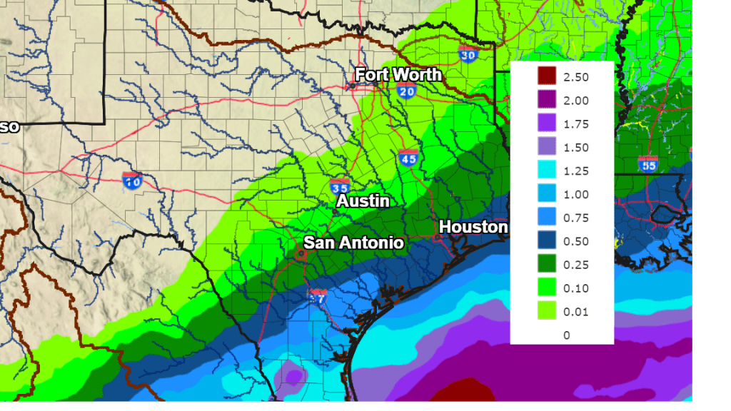
Rain amounts from this next system are not expected to be very heavy, with the highest totals expected across the coastal region. Totals through Saturday are forecast to average between 0.5 and 1 inch across the coastal plains, between 0.10 and 0.5 inches across Central Texas, and around a tenth of an inch or less across the Hill Country.
NWS Rainfall Forecast for the Period 6 pm Monday through 6 pm Saturday:
Following the passage of the upper trough, forecasts call for a Canadian cold front to sweep south across Texas late Friday night. Breezy, and cooler weather will follow cold front Saturday through Sunday. A light freeze will be possible for parts of the Hill Country next Sunday morning.
- High temperatures Saturday and Sunday are forecast to be in the mid and upper 50s.
- Lows Sunday morning will include the low 30s across the Hill Country, the low and mid-30s across Central Texas, and the mid-30s across the coastal plains.
- Lows Monday morning are forecast to be in the upper 30s to low 40s.
The outlook for next week calls for mostly sunny, dry, and mild weather conditions across the region. High temperatures are predicted to be in the upper 60s to low 70s. Lows are forecast to be mostly in the 50s.
The next chance for rain is expected to occur sometime late next week into the following weekend when the next Pacific trough of low pressure moves towards Texas out of the Desert Southwest.
Bob
Social Media