Thursday Update on the Threat for Severe Storms and Much Colder Temperatures
March 16, 2023
Afternoon observations and high-resolution forecasts indicate the threat for severe storms across the Hill Country and Central Texas regions for the remainder of the afternoon and into evening has decreased, with the greatest threat for severe storms having shifted to the east.
The forecast for this evening and tonight continues to show the a possibility for strong to severe thunderstorms developing across the region ahead of and along a strong cold front that will be pushing southeast. As of mid-afternoon Thursday, the cold front was located across Northwest Texas. Forecasts call for the front to spread across the Hill Country between roughly 7 pm and 10 pm, and the Austin/Interstate 35 corridor roughly between 9 pm and midnight. The front will continue moving southeast overnight, pushing off the middle Texas coast before sunrise Friday.
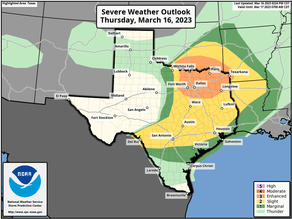
A broken line of thunderstorms is predicted to develop just ahead of along the cold front as it moves to the southeast. Some of these thunderstorms may become severe, with the primary severe weather threats being damaging straight-line winds and large hail. The Storm Prediction Center continues with a Slight Risk, or 2 out of 5 risk, for severe thunderstorms across the eastern half of the Hill Country and all of Central Texas through Thursday night.
Behind the initial line of thunderstorms, forecasts call for occasional light to moderate rain showers Thursday night through Friday morning. The rain is expected to taper off by Friday afternoon.
Rainfall forecasts remain unchanged. Totals across the Hill Country are forecast to generally be between 0.25 and 0.5 inches. Elsewhere, totals are forecast to range between 0.5 and 1 inch.
Windy and much cooler temperatures can be expected behind the cold front Thursday night through Friday. The National Weather Service has posted a Wind Advisory for the region beginning 9 pm Thursday night, continuing through noon on Friday. Expect northerly winds at 20-25 mph, with occasional gusts to 40 mph.
Temperatures are forecast to fall into the low 40s by sunrise Friday morning. Temperatures Friday afternoon are predicted to only warm into the low and mid-50s. Lows Saturday morning will include the mid-30s across the Hill Country, the upper 30s across Central Texas, and the low 40s across the coastal plains.
Do note forecasts have now trended for the development of a rain/snow mix across parts of the Hill Country beginning Friday night, continuing through midday Saturday as trough of low pressure tracks east out of Mexico. No significant impacts are expected as the surface temperature will be above freezing. However, minor accumulations can be expected on elevated and grassy surfaces. Elsewhere, just an occasional cold rain is expected Friday night and Saturday . All of the precipitation should taper off Saturday afternoon.
Unseasonably cold temperatures will continue through Monday.
Bob
Social Media