Turning Much Warmer Tuesday and Wednesday. Cooler Late Week and into the Weekend
May 6, 2024
Rounds of rain showers and thunderstorms since the middle of last week caused significant totals of rain across the Hill Country and Central Texas regions. According to LCRA’s Hydromet, the highest totals over the past 5 days occurred across the northern Hill Country across Mills, Lampasas, San Saba, and McCulloch Counties where amounts of 5-8 inches were recorded. Much of the region received between 1 and 2 inches of rain, with isolated totals of 3-4 inches. Interestingly, the heavy rains missed the middle Texas coast. Across Wharton and Matagorda Counties, totals over the past 5 days have only averaged around a quarter inch or less.
NWS Estimate of Rain Falling between 7 am Wednesday and 7 am Monday:
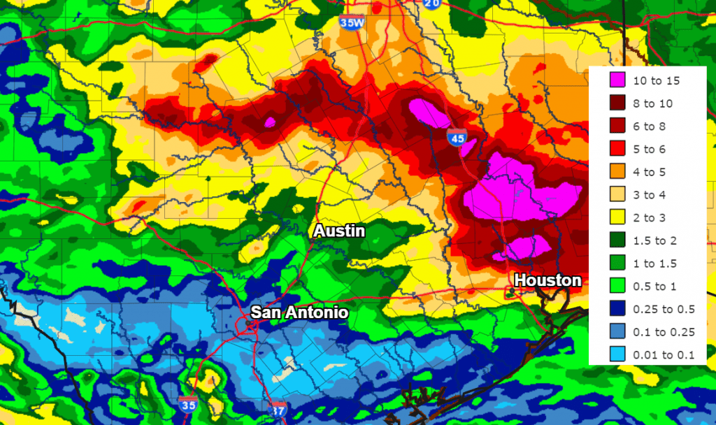
Data Courtesy NWS West Gulf River Forecast Center
The large trough of low pressure responsible for the recent stretch of wet and stormy weather across much of Texas has pushed off to the northeast. While this system has moved out, the base of a second trough of low pressure is currently moving from the Texas Panhandle region into the southern and central Plains states. This system will draw considerable clouds and moisture north from the Gulf of Mexico, resulting in a mostly cloudy sky Monday afternoon through Monday night. This system may generate a few widely scattered rain showers or isolated thunderstorms across the region Monday afternoon, but no significant rain is expected. Monday’s temperature is forecast to warm to the low and mid-80s. Lows Tuesday morning will are forecast to be in the upper 60s to low 70s.
A dry and warmer weather pattern is forecast for Tuesday and Wednesday as a ridge of high pressure temporarily spreads north across Texas out of Mexico. Widespread low clouds Tuesday and Wednesday mornings will give way to mostly sunny conditions both afternoons. This ridge is expected to bring unseasonably warm temperatures to the entire region.
- High temperatures Tuesday are forecast to be in the upper 80s across the Hill Country, and in the low 90s across Central Texas and the coastal region.
- High temperatures Wednesday are forecast to be in the low 90s region-wide.
- Lows Wednesday and Thursday mornings will generally be in the low 70s.
Due note: with the wet ground and a moist flow off the Gulf, afternoon heat index readings across the region may approach 100-108 degrees Tuesday and Wednesday.
A change in the weather is forecast to take place Thursday when a fairly strong cold front (for May standards) pushes south out of North Texas. Moisture convergence along the front is expected to cause the development of a few scattered rain showers and thunderstorms along the cold front. The probability for rain will only be near 20-30 percent. Forecasts call for rain amounts to average less than a quarter inch, with most areas remaining dry. Expect a partly to mostly cloudy sky Thursday and mostly sunny sky Friday through Saturday. The front will bring somewhat cooler air into the area Thursday through Friday.
- High temperatures Thursday will include the low 80s across the Hill Country, the mid-80s across Central Texas, and the low 90s across the coastal plains.
- Lows Friday and Saturday mornings will include the upper 50s to 60 degrees across the Hill Country, the low 60s across Central Texas, and the mid to upper 60s coastal plains.
- High temperatures Friday are forecast to be in the upper 70s across the Hill Country and Central Texas, and in the low 80s across the coastal plains.
- High temperatures Saturday are predicted to be around 80-82 degrees.
A chance for rain showers and scattered thunderstorms will return the outlook for Sunday, and this chance for rain looks to continue through most of next week. Forecasts call for a broad trough of low pressure to develop across the Desert Southwest on Sunday, with the trough then lingering over the area into early next week. The trough is forecast to sink south into Mexico and approach Texas through the second half of next week. Moisture spreading north from the Gulf will cause a 30-40 percent chance for scattered rains across the area Sunday through Tuesday, with an even higher chance for rain expected next Wednesday through Friday, possibly continuing into the following weekend as well. This forecast solutions are still trying to sort this picture out, but the overall pattern is looking wet and unsettled.
High temperatures next week are forecast to generally be in the mid-80s.
Bob
Social Media