Warm and Muggy through Late Week. A Good Chance for Rain this Weekend
April 16, 2024
Parts of the Hill Country and the Interstate 35 corridor have seen a few passing rain showers since Monday evening. The rain has been light, with totals averaging just a few hundredths of an inch. Meanwhile, little to no rain has fallen over the area located to the east of Interstate 35.
A trough of low pressure moving from the southern to the central Plains states has helped to push a Pacific cold front into the west central Texas. As of early Tuesday afternoon, the front stretched from Stephenville, to Llano, to near Del Rio. The front was separating a dry air mass to the west from a moist and very humid air mass to the east. Despite this change of air mass, the atmosphere overall is still fairly stable, so no significant rain or storms are forecast. The front has slowed its forward progress and is predicted to hold in its current position through Tuesday night. The front is then predicted to lift back to the north Wednesday morning.
For Tuesday afternoon and Tuesday night, expect a mostly cloudy to overcast sky for areas along and east of I-35. While a sprinkle or two will be possible, no significant rain is forecast. For most of the Hill Country, the sky will be mostly sunny Tuesday afternoon, then become mostly cloudy Tuesday night.
- High temperatures Tuesday afternoon will include the mid and upper 80s across the Hill Country, with low and mid-80s across Central Texas and the coastal plains.
- Lows Wednesday morning will range from the mid and upper 60s across the Hill Country, to the low 70s across the coastal plains.
Wednesday’s weather is shaping up to be mostly cloudy, warm, and humid. High temperatures are forecast to be around 90-92 degrees across the Hill Country, into the upper 80s across Central Texas, and in the mid-80s across the coastal plains. Lows Thursday morning are forecast to be near 70-72 degrees.
There will be 30 percent chance for scattered showers and thunderstorms for the Hill Country and Central Texas regions Thursday afternoon into Thursday evening as a couple of weak waves of low pressure push east out of West Texas. Scattered thunderstorms are forecast to develop Thursday afternoon along the dry line across West Texas and move to the east. There are indications some of these storms could be strong to severe. The Storm Prediction Center has placed the Hill Country and Central Texas regions under a Marginal Risk, or 1 out of 5 risk, for severe storms through Thursday night. The primary severe weather risk will be large hail. Spotty rain amounts to around a quarter inch will be possible.
- Thursday is predicted to be a warm day, with highs near 90-92 degrees across the Hill Country, near 90 degrees across Central Texas, and in the mid to upper 80s across the coastal plains.
Friday’s weather will feature morning clouds and a partly cloudy sky in the afternoon. There will be a 20 percent chance for a few scattered rain showers and thunderstorms across the Hill Country and Central Texas regions Friday afternoon. No rain is expected across the coastal region. Friday’s high temperature is forecast to be in the mid and upper 80s.
A wet and unsettled weather pattern is forecast Friday night and this weekend when a Canadian cold front slowly sags south across Texas and a trough of low pressure approaches from the west. Forecasts call for the front to move into the northern Hill Country late Friday afternoon, then stall in the area Friday night. The front is then forecast to get a push south into Central Texas Saturday afternoon and into the coastal region Saturday evening. Widespread overrunning showers and thunderstorms are forecast to develop across the northern Hill Country Friday evening and Friday night, with the activity shifting south with the front Saturday and Saturday night. The probability for rain will be near 80 percent. The rain should taper off from north to south late Saturday night into Sunday morning as the overrunning pattern diminishes. A mostly cloudy sky is predicted for Sunday afternoon.
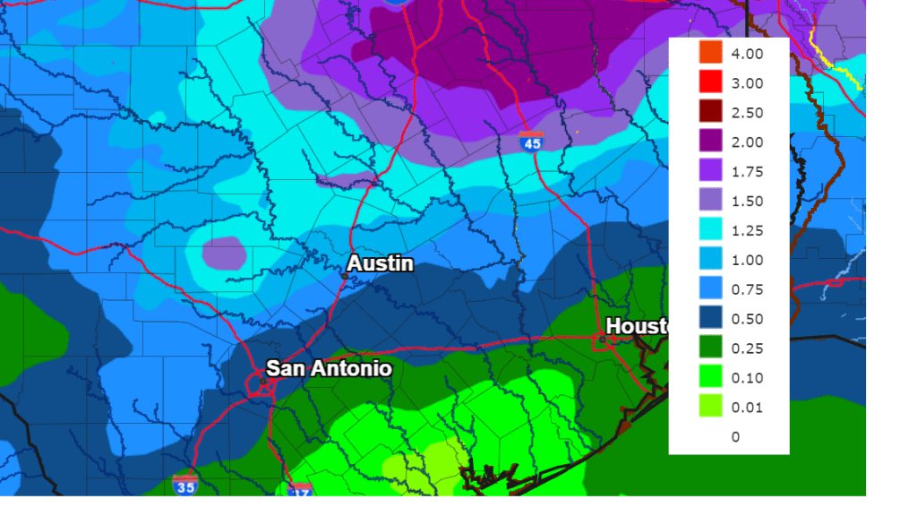
Forecasts call for the highest totals of rain to occur across the northern Hill Country and the northern counties of Central Texas where totals of 1-2 inches will be possible. Somewhat lower totals are forecast for the southern half of Central Texas and the coastal plains, where totals of 0.25 to 0.75 inches are forecast.
NWS Rainfall Forecast Valid through 7 pm Tuesday, April 23rd:
Much cooler air will arrive behind Saturday’s cold front.
- High temperatures Sunday will range from the mid-60s across the Hill Country, to the low 70s near the coast.
- High temperatures Monday are forecast to be in the mid-70s.
- Lows next Monday and Tuesday mornings will include the upper 40s across the Hill Country, the low 50s across Central Texas, and the mid-50s across the coastal plains.
Sunny weather is forecast through the first half of next week. Long-range solutions call for a chance for rain developing next Thursday and Friday. High temperatures are forecast to trend back to the mid and upper 80s for the second half of next week.
Bob
Social Media